Methods and apparatus for real-time projection and rendering of geospatially organized data

a geospatial organized, real-time technology, applied in the direction of instruments, navigation instruments, static indicating devices, etc., can solve the problems of difficult to achieve these goals, large number of cockpit displays, and lack of terrain benefit, obstruction, and other useful display data

Inactive Publication Date: 2005-07-26
HONEYWELL INT INC
View PDF29 Cites 50 Cited by
  • Summary
  • Abstract
  • Description
  • Claims
  • Application Information

AI Technical Summary

Problems solved by technology

One area in particular that has experienced an increase in display complexity is the field of electronic flight system instrumentation.
As instrument panel space is limited, achieving these goals can be quite difficult for designers faced with presenting a large amount of information within a relatively small space.
As a result, cockpit displays tend to be populated with numerous, non-intuitive icons and symbols, and without the benefit of terrain, obstruction, political boundaries, and other useful display data.

Method used


Image

  • Methods and apparatus for real-time projection and rendering of geospatially organized data
  • Methods and apparatus for real-time projection and rendering of geospatially organized data
  • Methods and apparatus for real-time projection and rendering of geospatially organized data

Examples


Embodiment Construction

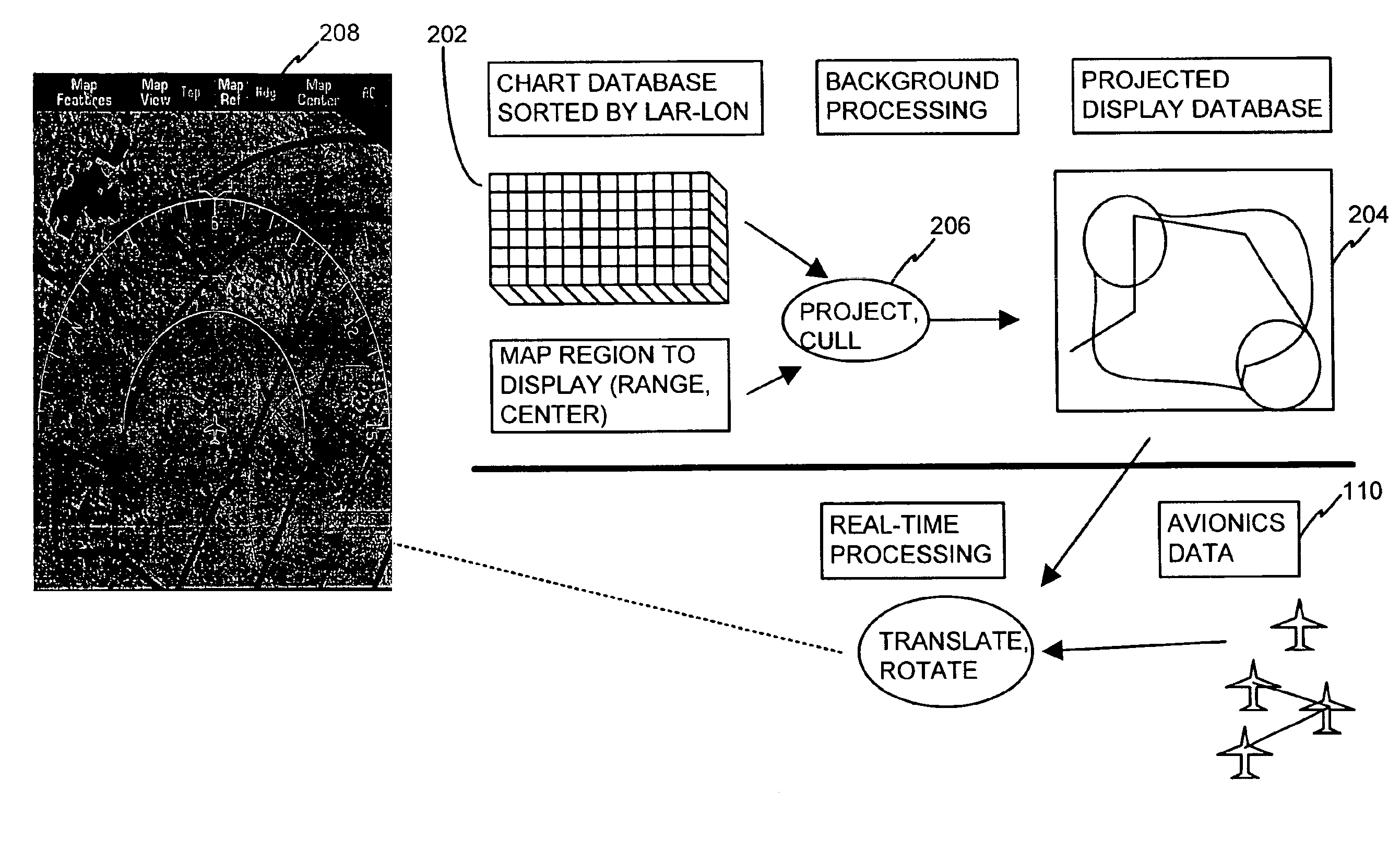
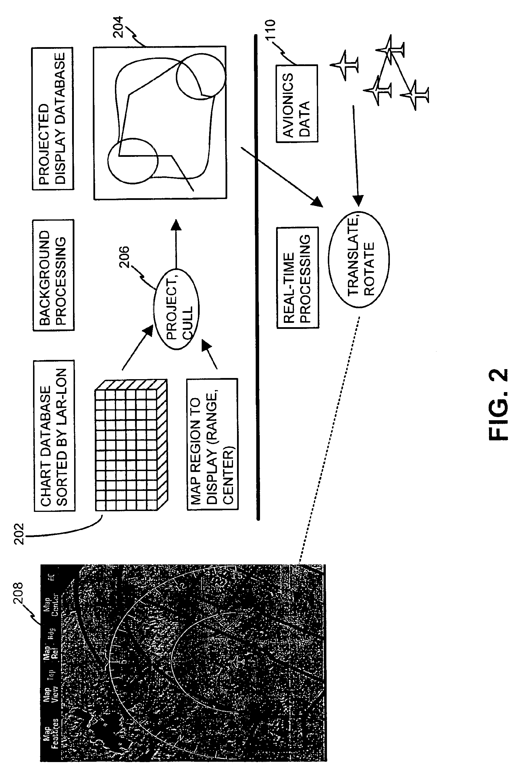
[0014]Systems and methods in accordance with various aspects of the present invention provide real-time projection and rendering of one or more geospatially organized navigation databases. The present invention may be described herein in terms of functional block components and various processing steps. It should be appreciated that such functional blocks may be realized by any number of hardware and / or software components configured to perform the specified functions. For example, the present invention may employ various integrated circuit components, e.g., memory elements, digital signal processing elements, look-up tables, and the like, which may carry out a variety of functions under the control of one or more microprocessors or other control devices. Such general techniques and components that are known to those skilled in the art are not described in detail herein.

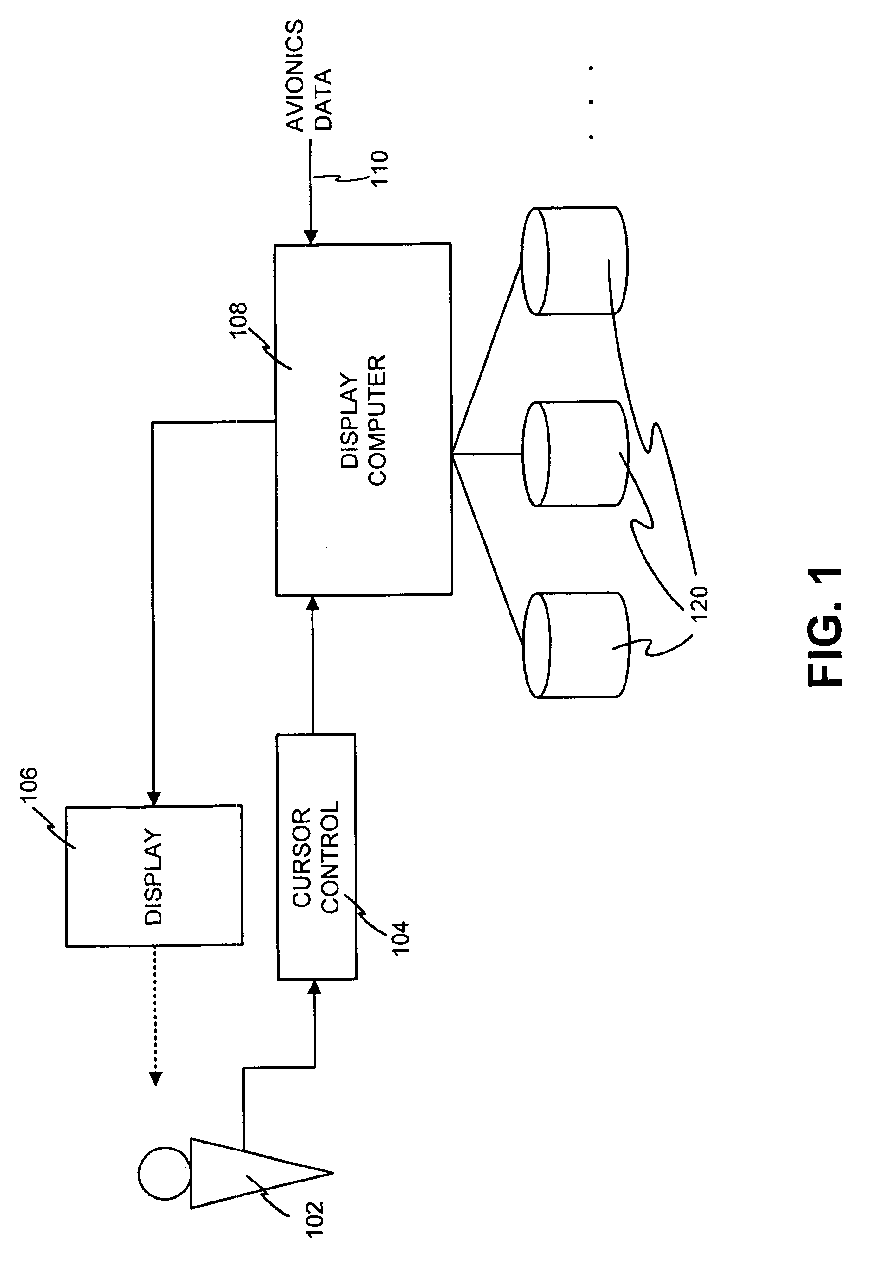
[0015]Briefly, referring now to FIG. 1, a system in accordance with various aspects of the present invention compr...


PUM


Abstract

Methods and apparatus are provided for real-time projection and rendering of one or more geospatially organized navigation databases. A system stores, processes, and displays a navigation database (including, e.g., terrain, navigation aids, obstructions, political boundaries, and the like) and avionics data to accomplish real-time display while maintaining correct projections of the data from latitude and longitude coordinates to Cartesian (nautical-mile) coordinates. Flight-plans may be graphically modified via an intuitive user interface.

Description

CROSS-REFERENCE TO RELATED APPLICATIONS[0001]This application claims the benefit of U.S. Provisional Patent Application Ser. No. 60 / 153,900, filed Sep. 14, 1999, the contents of which are hereby incorporated by reference.BACKGROUND OF THE INVENTION[0002]1. Technical Field[0003]The present invention relates, generally, to data display systems and, more particularly, to methods for real-time display and editing of aircraft navigation and flight-planning data.[0004]2. Background Information[0005]Electronic instrumentation displays continue to advance in sophistication, achieving increasingly higher levels of information density and, consequently, presenting a greater amount of visual information to be perceived and understood by the operator. In many applications, it is critical that visual displays provide a proper cognitive mapping between what the operator is trying to achieve and the information available to accomplish the task. As a result, such systems increasingly utilize human-...

Claims


Application Information

Patent Timeline
Patent Type & Authority Patents(United States)
IPC IPC(8): G06F17/00G01C23/00
CPCG01C23/005Y10S707/99945Y10S707/99942Y10S707/92
Inventor SNYDER, MARK I.TESKEY, GARYWILSON, BLAKE W.HILBERT, MATT
Owner HONEYWELL INT INC
Why Eureka
Try Eureka