Three-dimensional model generating system and method, and computer program therefor

Active Publication Date: 2006-01-03
IMAGE PROCESSING TECH
View PDF6 Cites 51 Cited by
  • Summary
  • Abstract
  • Description
  • Claims
  • Application Information

AI Technical Summary

Benefits of technology

[0022]According to the present invention, the three-dimensional shape of the ground can be extracted on the basis of altitude information of the ground, which is obtained by an airplane, a satellite, or the like. Also, appearance information of individual buildings can be suitably generated from altitude information mapped onto a two-dimensional plane and a building/road map. Also, a three-dimensional model of a building

Problems solved by technology

In such a case, a building such as a pyramid-shaped building having a shape that cannot be created by raising the

Method used


Image

  • Three-dimensional model generating system and method, and computer program therefor
  • Three-dimensional model generating system and method, and computer program therefor
  • Three-dimensional model generating system and method, and computer program therefor

Examples


Example

[0045]With reference to the drawings, embodiments of the present invention will be described in detail.

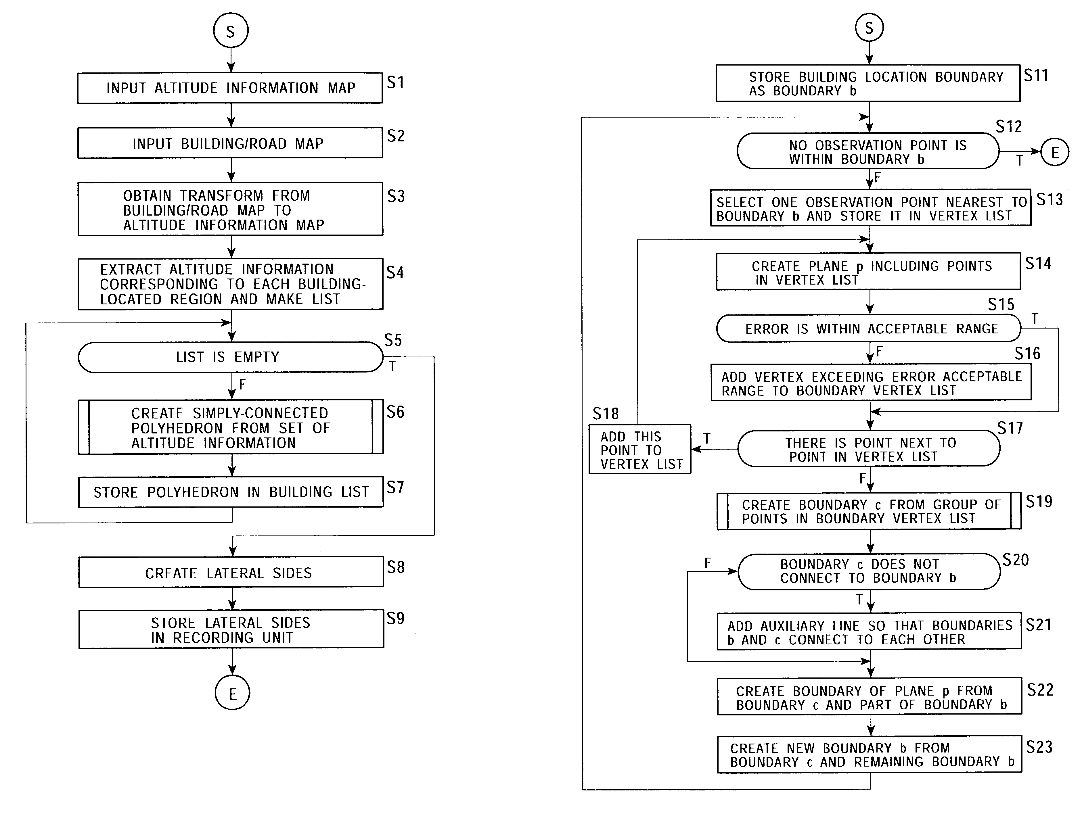
[0046]FIG. 1 shows the mapping of altitude information onto a two-dimensional plane. The two-dimensional plane shown in FIG. 1 represents the ground surface of a plain, mountain, suburb, or central city. Altitude information or elevation-data is obtained at predetermined intervals in the x and y directions and represented as a z-coordinate value of each point at the coordinates (x, y). The x and y axes correspond to, for example, the latitude and longitude, respectively.

[0047]Two-dimensional plane information including such altitude information covering an extensive region can be directly and easily generated by, for example, obtaining a range from space to the ground using an airplane, a satellite, or the like. Altitude information measured from space is compensated for geographical errors, and the altitude information is made into an ortho-image on the basis of the accurate geogr...


PUM


Abstract

A three-dimensional model generating system obtains altitude information corresponding to a specified building region on a building/road map. On the basis of the altitude distribution in the building region, a plane corresponding to a connected subset of observation data is obtained. After all pieces of observation data are allocated to planes, the planes are interconnected to form a simply-connected polyhedron serving as a building model. Accordingly, individual pieces of building information, which are free from the effects of a building-located region, are generated on the basis of three-dimensional terrain information and a set of planes.

Description

BACKGROUND OF THE INVENTION[0001]1. Field of the Invention[0002]The present invention relates to three-dimensional model generating systems and methods and computer programs therefor for extracting the three-dimensional shape of the ground on the basis of altitude information of the ground, which is obtained by an airplane, a satellite, or the like. In particular, the present invention relates to a three-dimensional model generating system and method and a computer program therefor for creating the appearance of a building having a three-dimensional shape on the basis of altitude information mapped onto a two-dimensional plane.[0003]More particularly, the present invention relates to a three-dimensional model generating system and method and a computer program therefor for creating appearance information of individual buildings from altitude information mapped onto a two-dimensional plane and a building / road map. In particular, the present invention relates to a three-dimensional mo...

Claims


Application Information

Patent Timeline
IPC IPC(8): G06T17/00G01V3/38G06T15/00G06T5/00G06T17/05G06T17/10G06V20/13
CPCG06K9/0063G06T7/0083G06T17/05G06T19/00G06T17/10G06T2210/04G06T2207/10032G06T2207/30184G06T7/12G06V20/13
Inventor OHTO, YASUNORI
Owner IMAGE PROCESSING TECH
Why Eureka
Try Eureka