
Map evaluation system, collation device, and map evaluation device

a technology of evaluation system and map, which is applied in the direction of editing/combining figures or texts, navigation instruments, instruments, etc., can solve the problems of inability to determine whether the contents of the database are correct or not, and the contents of the database cannot be immediately updated, so as to achieve the degree of credibility of the road map, and enable the degree of credibility. , the effect of high reliability

Inactive Publication Date: 2006-04-04
DENSO CORP
View PDF11 Cites 48 Cited by
  • Summary
  • Abstract
  • Description
  • Claims
  • Application Information

AI Technical Summary

Benefits of technology

[0008]It is an object of the present invention to provide a map evaluation system that quickly supplies a society with a highly reliable road map where actual road configuration is correctly included.
[0010]In the above structure, the difference information is generated based on the vehicle position path. Degree of accuracy for the difference information is then determined. By considering a result of the determination of the degree of accuracy, the degree of credibility for the road map is evaluated. This results in enabling the degree of credibility for the road map to be properly evaluated. A highly reliable evaluation result can be thereby outputted to users of the system. Location where a road is assumed to be newly constructed or modified is notified to the users through outputting. The users can thereby determine whether updating the road map is necessary. Accordingly, using of the map evaluation system of the present invention enables quickly supplying a society with a highly reliable road map where actual road configuration is correctly included. Furthermore, based on the evaluation result, the corresponding location can be actually investigated. The road map can be thereby updated based on the investigation result.

Problems solved by technology

However, in the above case, the person at the information center cannot determine whether contents of the database are correct or not.
Even when an actual road configuration is changed, the contents of the database cannot be immediately updated.

Method used


Image

  • Map evaluation system, collation device, and map evaluation device
  • Map evaluation system, collation device, and map evaluation device
  • Map evaluation system, collation device, and map evaluation device

Examples


Embodiment Construction

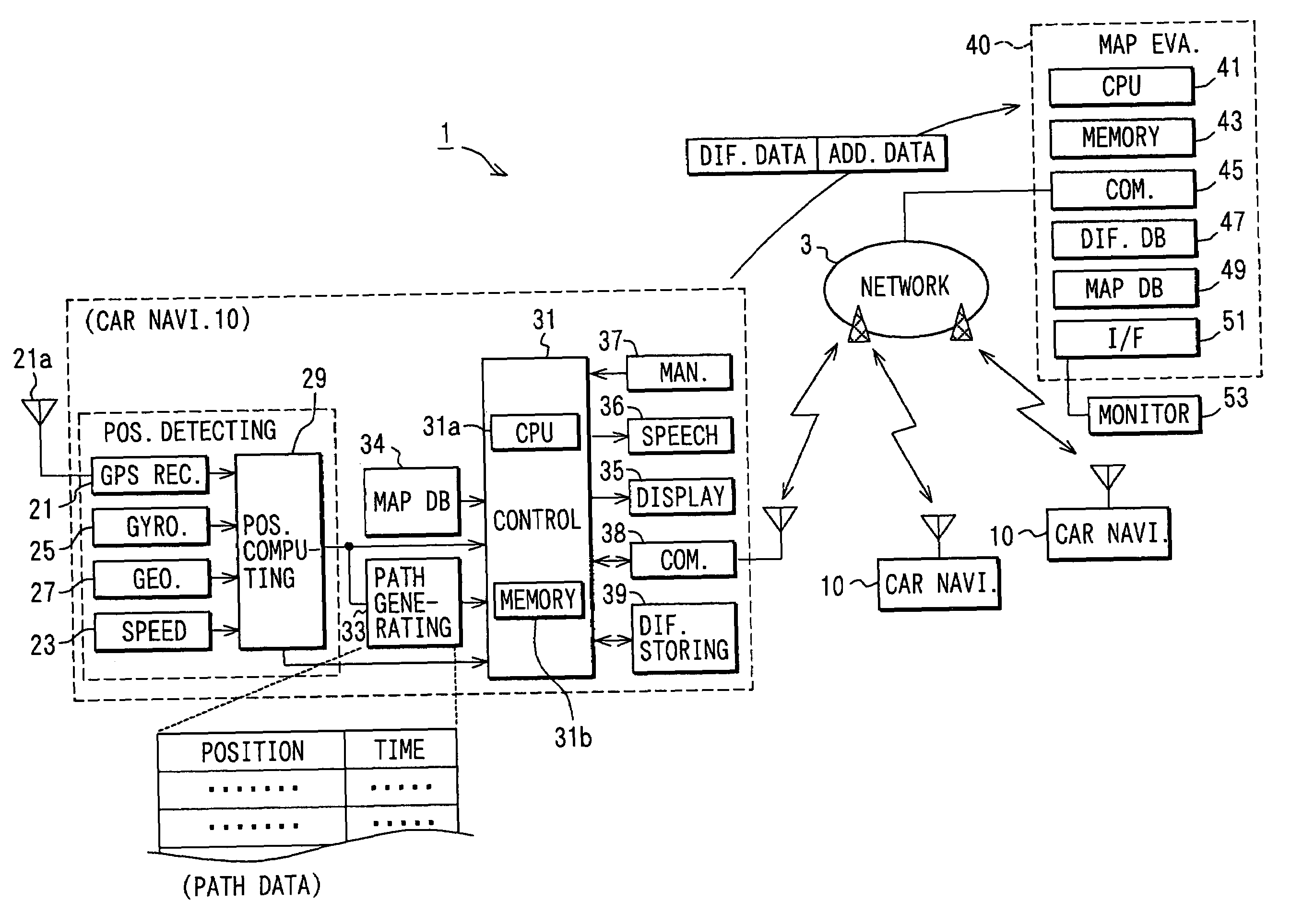
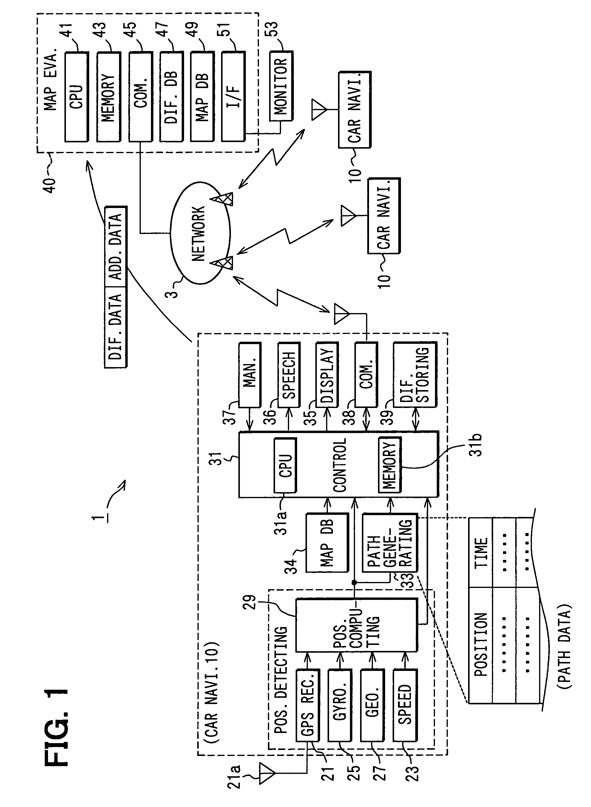
[0020]A map evaluation system 1, to which the present invention is directed, is equipped with a car navigation device 10, being as a collation device, and a map evaluation device 40, as shown in FIG. 1. The car navigation device 10 and the map evaluation device 40 are communicated with each other through a wide area network such as the Internet.

[0021]The car navigation device 10 is equipped with a position detecting unit 20, a path generating unit 33, a map database (DB) 34, a displaying unit 35, a speech outputting unit 36, a manipulating unit 37, a communicating unit 38, and a difference storing unit 39. The position detecting unit 20 includes a GPS receiver 21, a speed sensor 23, a gyroscope 25, and a geomagnetic sensor 27. The GPS receiver 21 receives satellite radio waves sent from GPS satellites via an antenna 21a to measure a current position of a vehicle where the car navigation device 10 is mounted. The speed sensor 23 detects a traveling speed of the vehicle. The gyroscope...


PUM


Abstract

A map evaluation system is equipped with a car navigation device and a map evaluation device. The car navigation system generates difference data indicating a location where a difference is present between a vehicle position path and a road location obtained from a map database. The car navigation device then sends the difference data along with additional data relating to accuracy of the difference data. The map evaluation device determines accuracy for the difference data based on the additional data. When the accuracy degree of the difference data is determined to be proper, the map evaluation device increments by one a determining count of a group including the difference data. When the determining count exceeds a given count, a portion to be amended on the map database is displayed on a monitor based on the difference data stored in a difference database.

Description

CROSS REFERENCE TO RELATED APPLICATIONS[0001]This application is based on and incorporates herein by reference Japanese Patent Application No. 2002-370663 filed on Dec. 20, 2002.FIELD OF THE INVENTION[0002]The present invention relates to a map evaluation system that evaluates and outputs a degree of credibility of a road map stored in a map database. The present invention furthermore relates to a collation device and map evaluation device used in the map evaluation system.BACKGROUND OF THE INVENTION[0003]A map display device is known. It reads out a road map from a map database and displays the read road map on a displaying unit such as a liquid crystal display. For instance, a car navigation device is known as the map display device.[0004]The car navigation system is equipped with a vehicle position detection device that detects a vehicle current position based on information obtained from a GPS receiver, a speed sensor, or the like. Position information obtained from the vehicle ...

Claims


Application Information

Patent Timeline
Patent Type & Authority Patents(United States)
IPC IPC(8): G01C21/30G09B29/00G01C21/00G01C21/32G06T11/60G08G1/0969G09B29/10
CPCG01C21/32G01C21/30G01C21/3844G01C21/3815G01C21/3859G01C21/3837
Inventor ITO, TOSHIYUKIMUTOH, KATSUHIKOKATOH, KOHJITANINO, HIDEKI
Owner DENSO CORP
Learn More