Display methodology for encoding simultaneous absolute and relative altitude terrain data

Active Publication Date: 2006-08-29
HONEYWELL INT INC
View PDF5 Cites 60 Cited by
  • Summary
  • Abstract
  • Description
  • Claims
  • Application Information

AI Technical Summary

Benefits of technology

[0013]The present invention overcomes the limitations of prior art terrain awareness displays and systems by providing method for dynamically displaying terrain situation awareness information. The method of the invention is embodied, by example and without limitation, in a display control device, having: a processor structured for receiving terrain elevation information and samples of current position and altitude above ground data; and one or more algorithms resident on the processor for gene

Problems solved by technology

By providing detailed data only for terrain elevations above the selected comfort zone, such systems fail to supply information about terrain that is not at present a pot

Method used


Image

  • Display methodology for encoding simultaneous absolute and relative altitude terrain data
  • Display methodology for encoding simultaneous absolute and relative altitude terrain data
  • Display methodology for encoding simultaneous absolute and relative altitude terrain data

Examples


Embodiment Construction

[0025]In the Figures, like numerals indicate like elements.

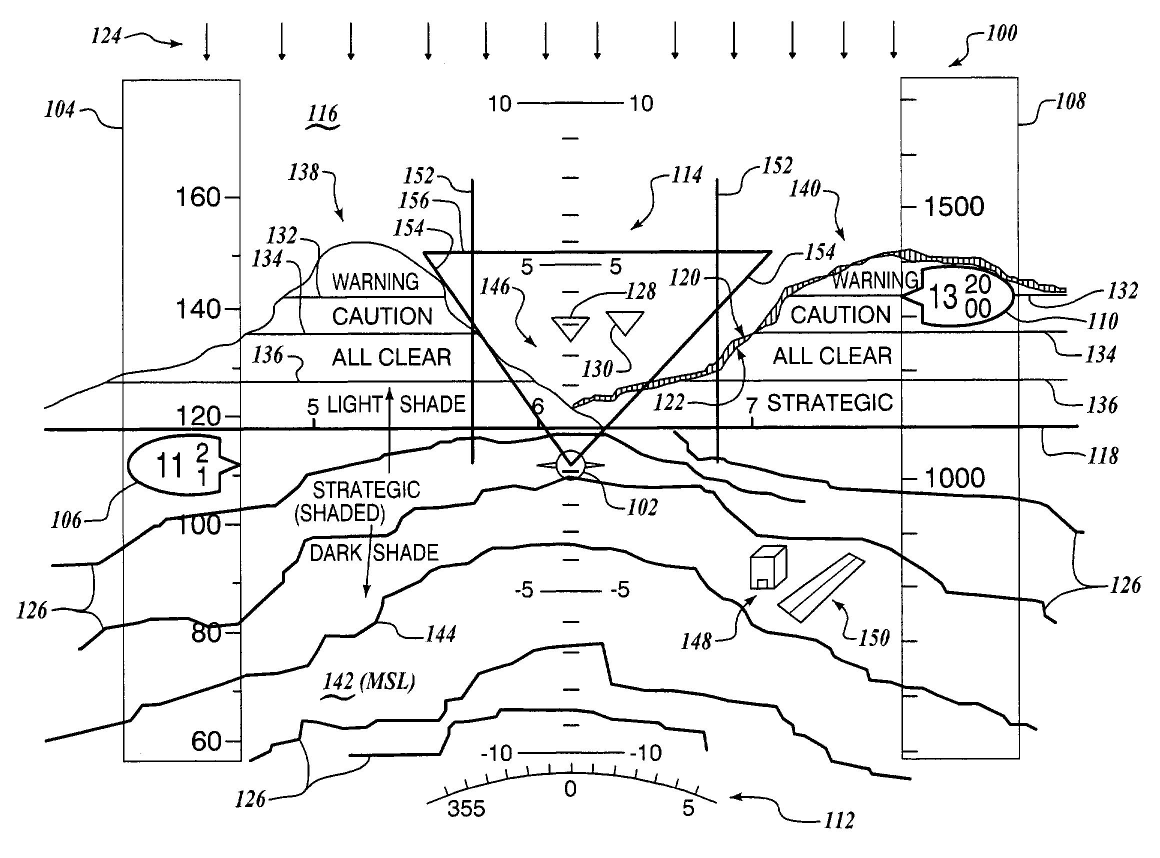
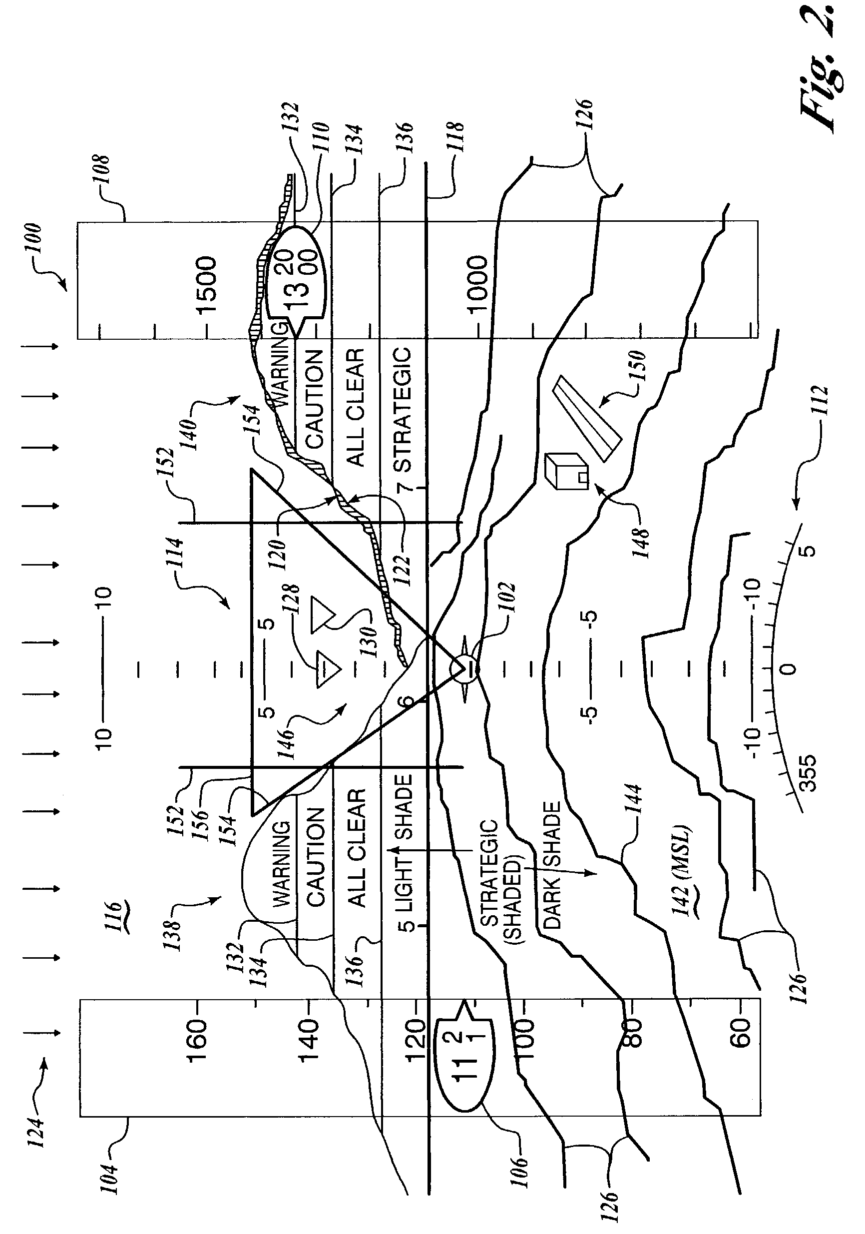
[0026]The present invention is an integrated display apparatus, method and computer program product for dynamically displaying terrain situation awareness information over a selected distance relative to an aircraft's current position and altitude by receiving at intervals one or more signals representative of current position, one or both of a current heading and a current track, altitude above ground data, and optionally current speed over ground and acceleration data; retrieving a plurality of terrain elevation data as a function of the position and one or both of the current heading and track data, where “heading” and “track” are defined according to common usage in aviation so that “heading” refers to a direction in which the nose of the aircraft is pointing, while “track” refers to a direction or “course” over the ground actually flown by the aircraft; and displaying a color coded representation of a strategic portion ...


PUM


Abstract

A display control device, having a processor structured for receiving terrain elevation information and samples of current position and altitude above ground data; and one or more algorithms resident on the processor for generating, as a function of the current position and altitude above ground data, one or more display control signals for causing a display device to display, in a monochromatic scale graduated as a function of terrain elevation relative to mean sea level, a strategic portion of the terrain elevation information extending between a minimum elevation of the strategic portion of the terrain elevation information and a pre-selected strategic altitude threshold less than the altitude above ground data.

Description

[0001]This application claims the benefit of U.S. Provisional Application Ser. No. 60 / 445,302, filed in the names of Thea L. Feyereisen, and Christopher J. Misiak on Feb. 4, 2003, the complete disclosure of which is incorporated herein by reference.FIELD OF THE INVENTION[0002]The present invention relates generally to apparatus and methods for displaying terrain data; and in particular to displaying relative altitude terrain data in a strategic format.BACKGROUND OF THE INVENTION[0003]Visual display systems for providing an aircraft pilot terrain situational awareness and real-time, dynamic display of any terrain hazards are generally well-known. Typically, such displays show terrain and potential hazards formatted in either a horizontal terrain elevation view or a profile terrain elevation view relative to the host aircraft's position, altitude and heading.[0004]FIG. 1 shows a known terrain situation awareness display 10 that illustrates by example on the upper portion a horizontal ...

Claims


Application Information

Patent Timeline
IPC IPC(8): G08B23/00G08G5/00
CPCG01C23/00G08G5/0086G08G5/0021
Inventor FEYEREISEN, THEA L.MISIAK, CHRISTOPHER J.
Owner HONEYWELL INT INC
Why Eureka
Try Eureka