
System and method for determining oil or mineral deposits

a technology of oil or mineral deposits and systems, applied in the field of systems and methods, can solve the problems of no prediction algorithm, no search evaluation team, no on-the-ground technical data collection, etc., and achieve the effect of reducing the area of eyes-on analysis

Active Publication Date: 2007-05-22
HARRIS CORP +1
View PDF11 Cites 16 Cited by
  • Summary
  • Abstract
  • Description
  • Claims
  • Application Information

AI Technical Summary

Benefits of technology

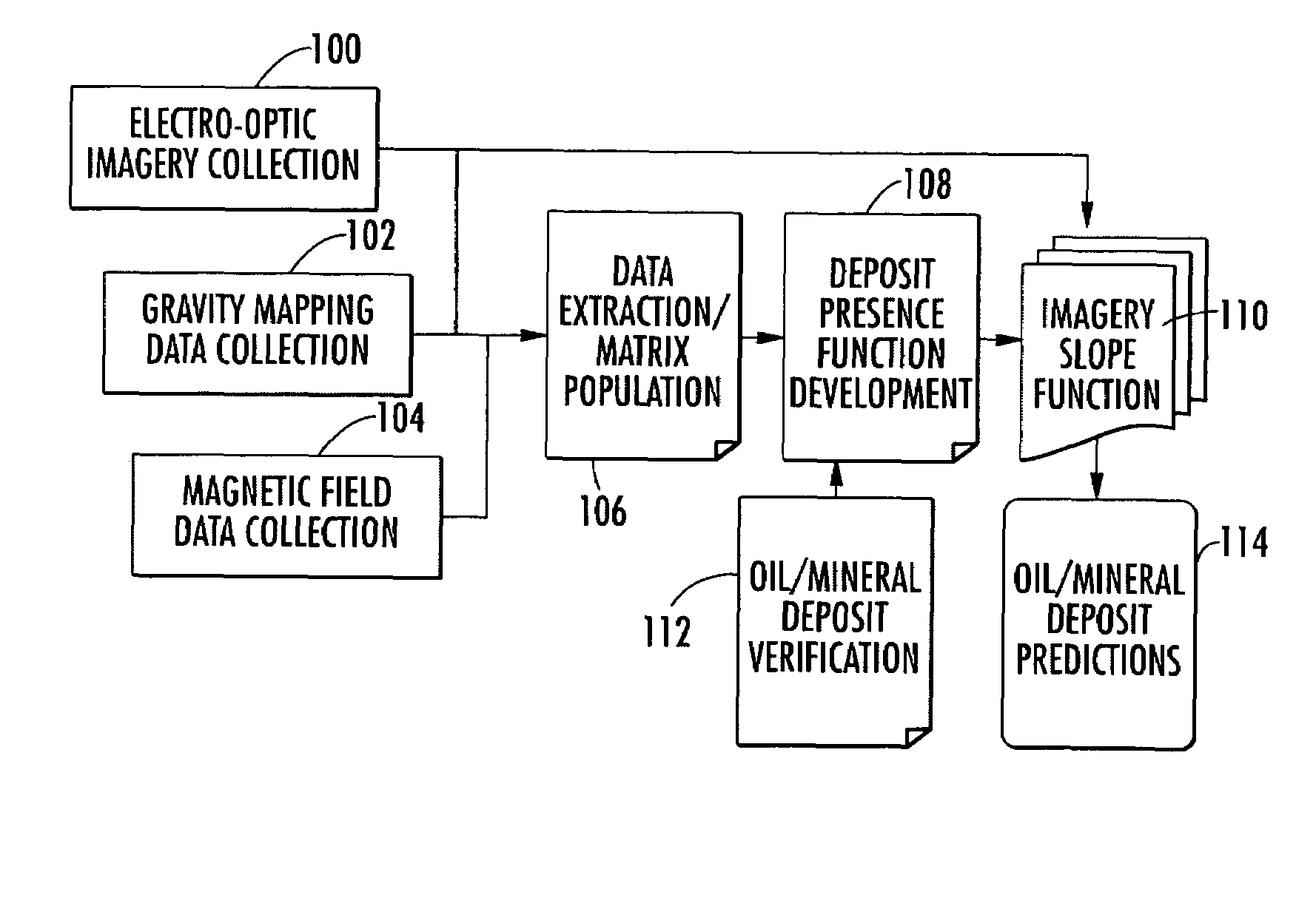
The present invention is a system and method for using data from elevation slope, magnetic, and gravity sensors to determine the likelihood of oil or mineral deposits in a specific area of the earth's surface. The system collects data from multiple sources and applies an algorithm to analyze the data and create a map of the area's geological resources. This reduces the need for on-the-ground analysis and allows for the use of commercial satellite and airborne data. The system uses a transfer function to link the elevation slope data to the likelihood of oil or mineral deposits, and can also create vector representations of the data to further enhance the analysis. Overall, the invention improves the efficiency and accuracy of oil and mineral deposit searches, making it easier to identify and develop these valuable resources.

Problems solved by technology

These searches are typically localized, requiring time-consuming search and evaluation teams.
In some techniques used in oil and gas exploration, geological research requires laborious hands-on, on-the-ground technical data collection using gradiometers and magnetometers.
There is no prediction algorithm, however.

Method used


Image

  • System and method for determining oil or mineral deposits
  • System and method for determining oil or mineral deposits
  • System and method for determining oil or mineral deposits

Examples


Embodiment Construction

[0029]The present invention will now be described more fully hereinafter with reference to the accompanying drawings, in which preferred embodiments of the invention are shown. This invention may, however, be embodied in many different forms and should not be construed as limited to the embodiments set forth herein. Rather, these embodiments are provided so that this disclosure will be thorough and complete, and will fully convey the scope of the invention to those skilled in the art. Like numbers refer to like elements throughout, and prime notation is used to indicate similar elements in alternative embodiments.

[0030]The present invention is advantageous and combines disparate physical property data types, such as magnetic data and terrain slope, when searching for oil or mineral deposits. The present invention provides an improved multi-dimensional function to determine the likelihood of finding such deposits. For purposes of understanding the present invention, a background expl...


PUM


Abstract

A system and method determines the probability of oil or mineral deposits. At least one data collection device collects elevation slope, magnetic and gravity data sets for a predetermined area of the earth's surface. A processor receives the elevation slope, magnetic and gravity data sets and applies the gravity and magnetic data sets in a transfer function to link the elevation slope data set to the likely presence of oil or mineral deposits.

Description

FIELD OF THE INVENTION[0001]The present invention relates to using disparate data sources for determining oil or mineral deposits, and more particularly, the present invention relates to using elevation slope, gravity, and magnetic data in a prediction algorithm for determining the presence of oil or mineral deposits in a predetermined area of the earth's surface.BACKGROUND OF THE INVENTION[0002]Many different types of searches are used for exploring and developing geological resources, such as oil, gas or mineral deposits. These searches are typically localized, requiring time-consuming search and evaluation teams. In some techniques used in oil and gas exploration, geological research requires laborious hands-on, on-the-ground technical data collection using gradiometers and magnetometers. Remote sensing is typically not involved in these searches, except for a cursory classification of geostrata, for example, used in slope determination.[0003]In the last few years, commercial sat...

Claims


Application Information

Patent Timeline
Patent Type & Authority Patents(United States)
IPC IPC(8): G01V3/00G01V3/16G01V11/00G06F19/00
CPCG01V11/00
Inventor KNIGHT, BYRON F.HAMILTON, MARK K.
Owner HARRIS CORP
Learn More