Method for constructing 3-D geologic models by combining multiple frequency passbands

a geologic model and frequency passband technology, applied in the field of geologic modeling, can solve the problems of difficult to identify components that have a physical interpretation, difficult to identify components, and model perturbations in the frequency domain, and achieve the effect of greater accuracy

Active Publication Date: 2008-08-19
EXXONMOBIL UPSTREAM RES CO
View PDF32 Cites 35 Cited by
  • Summary
  • Abstract
  • Description
  • Claims
  • Application Information

AI Technical Summary

Benefits of technology

[0029]The present invention provides a geologic modeling method wherein different resolution-scale data types are integrated. In accordance with the method, one or more frequency-passband models are constructed, combined, and then optimized to form the complete geologic model. The method provides the model builder with the ability to integrate multiple data types with greater accuracy.

Problems solved by technology

One such disadvantage is identifying components of the data.
With factorial kriging, it may be difficult to identify components that have a physical interpretation, for example, to identify the component that exactly represents the spatial scale of the seismic data.
One such disadvantage is that model perturbations are performed in the amplitude spectrum in the frequency domain.
It is much more difficult to control the effect of the perturbation when it occurs in the frequency domain than in the space domain.
In addition, the model cannot easily be conditioned to well data when perturbation occurs in the frequency domain.
Seismic-inversion methods are generally deficient for purposes of geologic modeling because they result in models of acoustic impedance only and contain no information at finer resolution than seismic scale.
Deficiencies of the Prior Art Modeling Techniques
Prior art geologic modeling technologies do not properly account for different spatial scales of multiple diverse data types.
As such, inaccuracies in the geologic model can result.
Use of an inaccurate model may be very costly, resulting in inaccurate estimates of hydrocarbon reserves, missed hydrocarbon-reservoir targets, and inappropriate reservoir-development strategies.
Most prior art geologic-modeling technologies fail to recognize that different data types used in constructing the model contain information at different scales and frequency content.
This deficiency is particularly true when integrating seismic information into the geologic model.
As a consequence of omitting this information, seismic data do not directly measure absolute rock property values nor generally measure slowly varying trends in these properties, e.g., as a result of burial compaction.
Direct integration of these estimates into the model without also integrating the low-frequency information will lead to inaccuracies.
If these estimated properties are integrated directly into the geologic model, the result might not properly reflect the high-frequency heterogeneity that occurs in the reservoir and that affects simulated fluid flow.
Deficiencies in these methods include an inability to identify spatial components that have physical interpretations, a difficulty in controlling model perturbations, and, most notably, an assumption that the individual spatial components are independent sources of information.
For example, if shale volume (VSH) is modeled by summing multiple spatial components, the sum of all components can never exceed 100% because this would represent a physical impossibility since the total value would exceed 100%.

Method used


Image

  • Method for constructing 3-D geologic models by combining multiple frequency passbands
  • Method for constructing 3-D geologic models by combining multiple frequency passbands
  • Method for constructing 3-D geologic models by combining multiple frequency passbands

Examples


Embodiment Construction

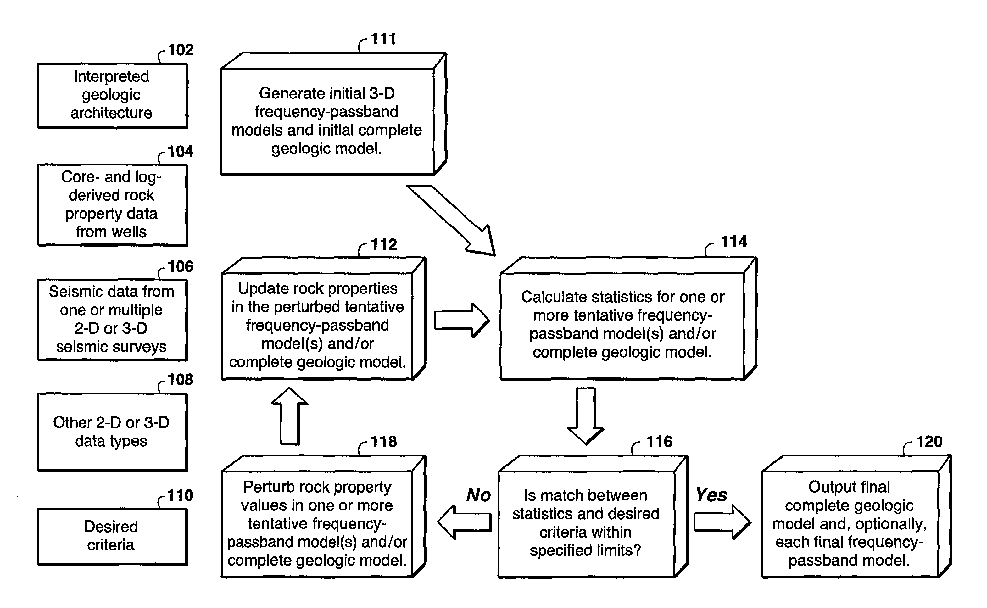
[0040]With reference to FIG. 3, the geologic modeling method of the present invention involves integrating different resolution-scale data types by constructing one or more initial frequency-passband models, combining these initial models to form an initial complete geologic model, and then optimizing one or more of these initial models to form the final complete geologic model. This is done using data which includes interpreted geologic architecture 102 that defines the limits of the model, regions within the model and stratigraphic correlations within the model, and desired criteria 110 that define the distributions and relations of rock properties in the complete geologic model and / or one or more of the individual frequency-passband models. Optionally, and desirably, several data types may be used in constructing the initial frequency passband models, including rock property data 104 derived from core and well logs, seismic data 106 derived from seismic surveys, and other data ty...


PUM

PropertyMeasurementUnit
seismic frequencyaaaaaaaaaa

Abstract

A process for constructing a three-dimensional geologic model of a subsurface earth volume wherein resolution scales of multiple diverse data types, including seismic data, are accounted for by generating multiple frequency passband models and combining them together to form the complete geologic model. Preferably, a model is generated for each of a low-frequency passband, a mid-frequency passband, and a high-frequency passband. When integrating seismic data into the modeling process, the seismic-frequency passband constitutes the mid-frequency passband model. The process further contemplates updating tentative frequency-passband models through optimization of assigned rock property values in each tentative model according to specified geological criteria. Such optimization is carried out by perturbation of the rock property values in a manner wherein the frequency content of each model is maintained.

Description

[0001]This application claims the benefit of U.S. Provisional Application No. 60 / 229,407 filed Aug. 31, 2000.BACKGROUND OF THE INVENTION[0002]1. Field of the Invention[0003]This invention generally relates to geologic-modeling. More specifically, this invention relates to a three-dimensional geologic modeling technique wherein multiple frequency-passband model units are combined together to form the complete geologic model.[0004]2. Description of the Prior Art[0005]A. Geologic Modeling[0006]As used in the context of the present invention, a geologic model is a computer-based representation of a region of the subsurface, such as a petroleum reservoir or a depositional basin. A geologic model may take on many different forms. Most commonly, descriptive or static geologic models built for mining or petroleum applications are in the form of a three-dimensional array of individual model units or blocks (also referred to as cells) or less commonly points. Hereafter, geologic models will b...

Claims


Application Information

Patent Timeline
Patent Type & Authority Patents(United States)
IPC IPC(8): G06G7/50G01N15/08G01R23/02G01V1/00G01V1/16G06G7/48G01V1/28G01V11/00
CPCG01V1/282G01V11/00G01V2210/66
Inventor CALVERT, CRAIG S.BISHOP, GLEN W.MA, YUAN-ZHEYAO, TINGTINGFOREMAN, J. LINCOLNSULLIVAN, KEITH B.DAWSON, DWIGHT C.JONES, THOMAS A.
Owner EXXONMOBIL UPSTREAM RES CO
Why Eureka
Try Eureka