Method and system for selective route search on satellite navigators

a satellite navigation and selective route technology, applied in the field of satellite navigation systems for motor vehicles, can solve problems such as limiting access to motor vehicles

Active Publication Date: 2009-01-27
MAPLEBEAR INC
View PDF30 Cites 29 Cited by
  • Summary
  • Abstract
  • Description
  • Claims
  • Application Information

AI Technical Summary

Problems solved by technology

As all societies become more conscious of petroleum fuel consumption, some routes, particularly in world urban centers, are known to limit access to motor vehicles based on vehicle constructions, and characteristics.

Method used


Image

  • Method and system for selective route search on satellite navigators
  • Method and system for selective route search on satellite navigators
  • Method and system for selective route search on satellite navigators

Examples


Embodiment Construction

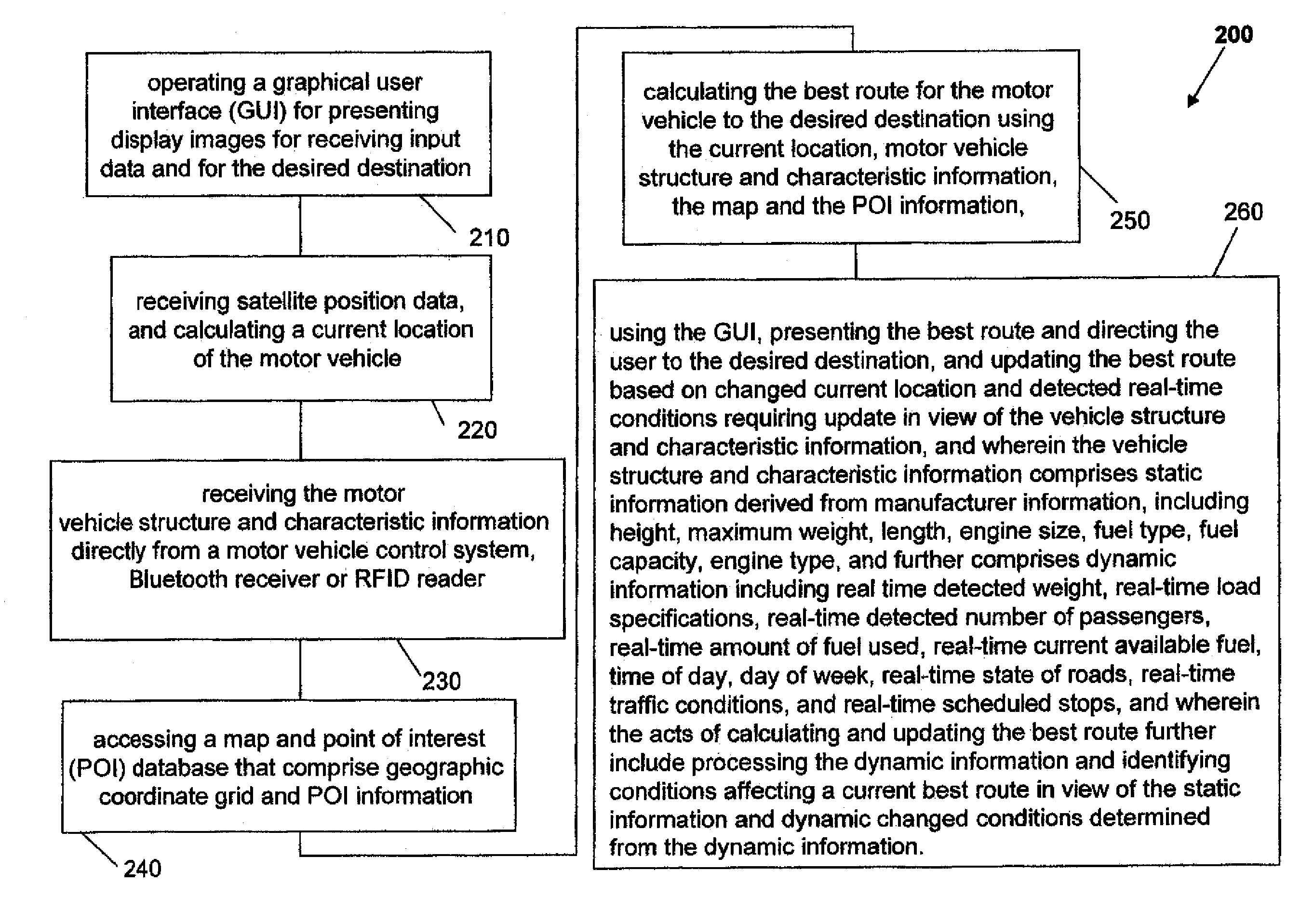
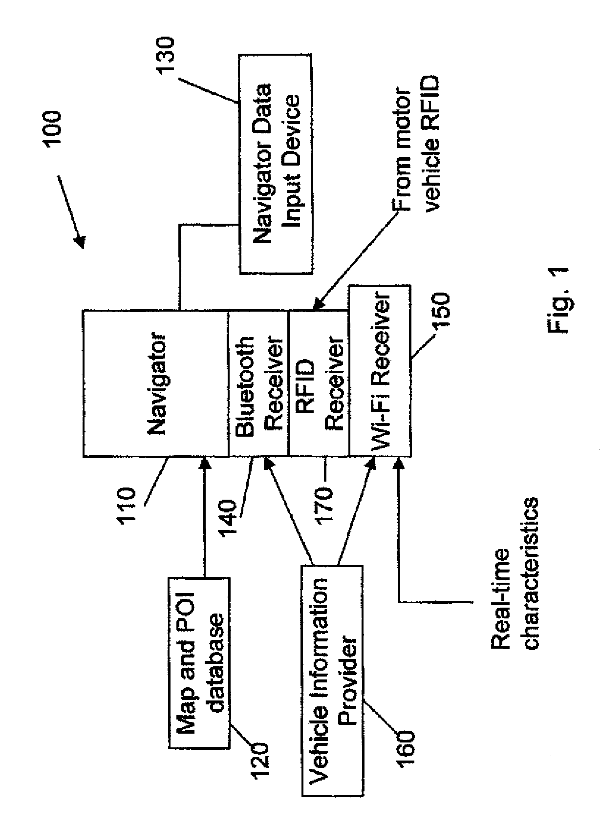
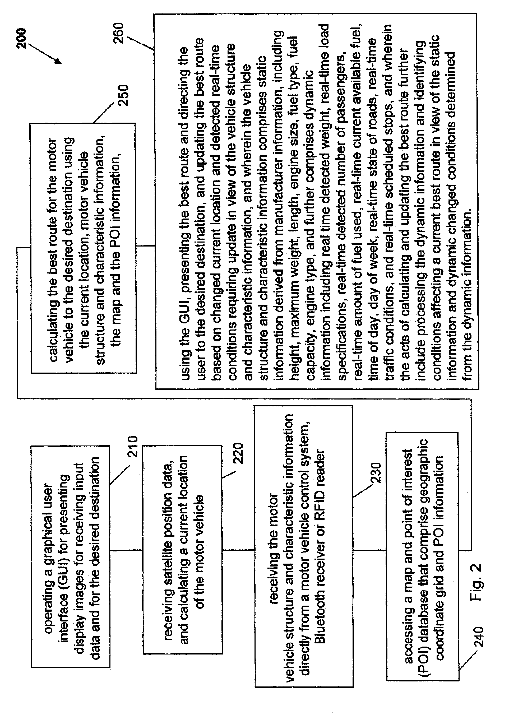
[0017]In a hardware embodiment, the invention comprises a vehicular satellite navigation system (Navigator) in a compact mechanical housing with a battery power supply, or connection to a vehicular power supply. The Navigator operates in accordance with a method for calculating a best route to a user destination that accounts for the motor vehicle structure and characteristics. A route is a series of streets, roads, junctures, bridges, bypasses, overpasses, underpasses, highways, expressways, freeways, etc. without limitation, separately linking a current motor vehicle (Navigator) location to an entered destination. Once a best route is calculated, the various street views directing the user are displayed as various map images, which include point of interest (POI) information if correlated to the current directional map coordinates, in a Navigator display device. Preferably, synthesized verbal instructions are also presented. The housing includes integrated electronics, memory comp...


PUM


Abstract

A method of operating a motor vehicle satellite navigation system using a motor vehicle's structure and characteristic information to calculate a best route to a desired destination. The method includes operating a graphical user interface (GUI), presenting display images for receiving input data for the desired destination and receiving satellite position data, and calculating a current location of the motor vehicle. The GUI presents a display image requesting motor vehicle structure and characteristic information. The method includes calculating and updating current best routes to a desired destination using map and POI databases comprising geographic coordinate grid and point of interest information from the current location and motor vehicle structure and characteristic information. The motor vehicle structure and characteristic information reflects static vehicle structure and characteristics such as size, fuel type, engine efficiency and fuel capacity, and dynamic information such as current fuel level and real-time traffic and road condition information.

Description

FIELD OF THE INVENTION[0001]The present invention relates to satellite navigation systems, and in particular to a motor vehicle satellite navigation system that calculates a best route for the particular motor vehicle in which it is installed or included by use of information related to the particular motor vehicle structure and characteristics and road information.BACKGROUND OF THE INVENTION[0002]Motor vehicle (e.g., automobile) navigator systems (Navigators) are satellite-based navigation devices. Navigators include a global positioning system (GPS), and are very popular among motorists over the world because of their ease of use in enabling even the most unseasoned drivers to reach their destination through directions / maps provided by the Navigator. With a Navigator, users can jump into their car, or other motor vehicle, enter their desired destination into the Navigator and set off driving while leaving the Navigator to direct them with turn-by-turn instructions at junctions, ro...

Claims


Application Information

Patent Timeline
Patent Type & Authority Patents(United States)
IPC IPC(8): G01C21/00G08B1/00
CPCG01C21/3476G01C21/3492G08G1/096827G08G1/096844
Inventor SIDOTI, STEFANOPICCININI, SANDROSECCHI, MARCOPICHETTI, LUIGI
Owner MAPLEBEAR INC
Why Eureka
Try Eureka