Generating and serving tiles in a digital mapping system
What is Al technical title?
Al technical title is built by PatSnap Al team. It summarizes the technical point description of the patent document.
a mapping system and tile technology, applied in the field of mapping systems, can solve the problems of system waste, large amount of data, and large amount of data, and achieve the effect of simplifying deployment and reducing the need for disk access
Active Publication Date: 2009-10-06
GOOGLE LLC
View PDF50 Cites 164 Cited by
Summary
Abstract
Description
Claims
Application Information
AI Technical Summary
This helps you quickly interpret patents by identifying the three key elements:
Problems solved by technology
Method used
Benefits of technology
[0012]At least one of the front end tile servers can be configured to identify one or more uni-colored map tiles, and is configured to serve the uni-colored map tiles, without having to request those uni-colored map tiles from one of the back end tile servers. In one such embodiment, the one or more uni-colored map tiles are stored in a memory cache included in the at least one front end tile server, thereby reducing the need for disk access associated with serving those uni-colored map tiles. In another such embodiment, the user is communicating with the at least one front end server using a computing device, and the at least one front end server causes the computing device to use uni-color map tiles that are locally available to the computing device, so that such tiles do not have to be served.
[0013]Each of the map tiles can be associated, for example, with an N×N block of map tiles, and each time a map tile is requested, all N2 tiles in the corresponding N×N block can be served. All of the N2 tiles can be cached as well. In other embodiments, the map tiles can be associated, for example, with an N×M block of map tiles (i.e., the block need not be square). The number of back end servers can be such, that each back end server can be used to serve a particular sub-set of the map tiles. Here, each back end server can be capable of caching all or parts of its corresponding sub-set. Each back end tile server can be dedicated to serving a sub-set of the map tiles, and each front end tile server can be configured to identify an appropriate back end server to use in satisfying a user request for a map tile. In one such embodiment, each front end tile server uses a hashing function based on map tile coordinates to identify the appropriate back end server. Note that the back end tile servers do not need to know which sub-set they are serving, which can simplify deployment.
[0017]Another embodiment of the present invention provides a method for generating digital map tiles from digital map data. The method includes identifying areas to be drawn, and various zoom levels at which each area needs to be drawn. The method continues with dividing the areas into sub-areas as needed at the different zoom levels, such that each sub-area can be pre-rendered in an available memory. The method continues with pre-rendering each sub-area at a given zoom level, and then dividing each pre-rendered sub-area into rendering areas, such that each rendering area can be rendered in the available memory. The method continues with rendering the rendering areas to produce an image, and dividing the image into map tiles. The pre-rendering each sub-area may include, for example, accessing at least one of geographical data sets and a representation of instructions about how to build the digital map image. The instructions can be represented, for instance, in a configuration file. The sub-areas can each have a pre-determined fixed size for each zoom level. In one particular embodiment, pre-rendering decisions prevent problematic features from crossing borders between sub-areas. Alternatively, in another embodiment, pre-rendering decisions allow features to cross borders between sub-areas. In such a case, two aligning sub-areas associated with a border crossing feature are not allowed to be pre-rendered at the same time. Pre-rendering decisions can be stored so they can be used in subsequent pre-rendering tasks (which enables features to cross borders between sub-areas).
Problems solved by technology
Whether vector-based or raster-based, these existing systems typically exhibit very poor performance.
In particular, the resulting maps tend to be small and move slowly.
Such systems are wasteful, as they fail to recognize and exploit the 50% overlap between the new and old map views.
In the vector-based case, the addition need to produce a map image from vectors in real-time tends to result in maps that are generally hard to read and lack a professional look and feel, thereby detracting from the user experience.
While this latter approach can result in a dramatic improvement in the user experience, the need to install software on a user's computer may prevent its widespread adoption.
Method used
Image
Click on the blue label to locate the original text in one second.
Reading with bidirectional positioning of images and text.
Examples
Embodiment Construction
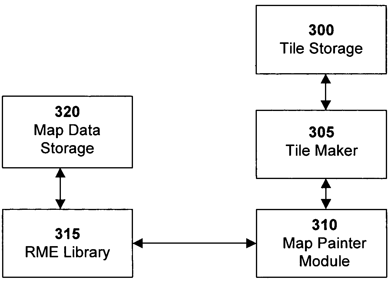
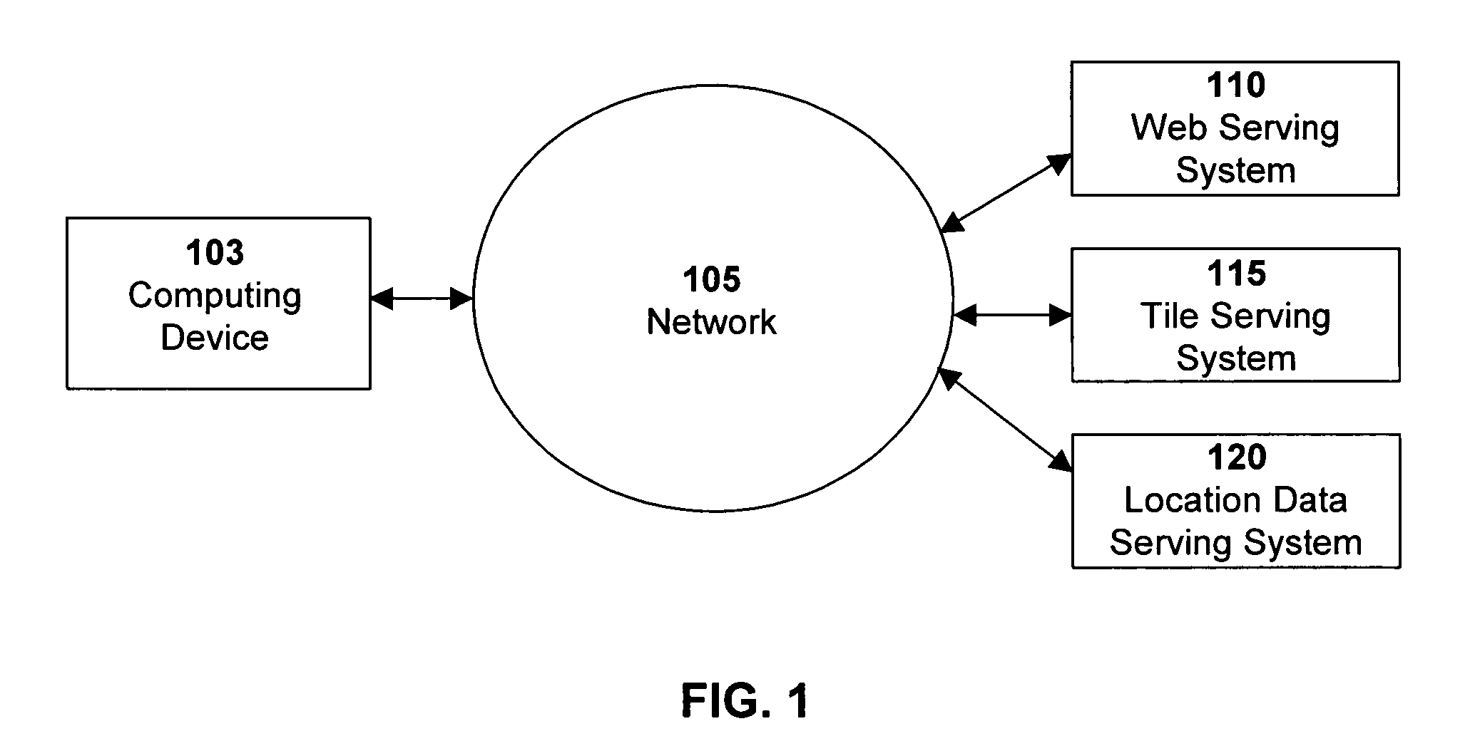
[0026]Digital tile-based mapping techniques are disclosed that enable efficient online serving of aesthetically pleasing maps. In one particular embodiment, an image tile-based digital mapping system is configured for generating map tiles during an offline session, and serving selected sets of those tiles to a client when requested. Also provided are solutions for handling map labels and other such features in a tile-based mapping system, such as for example when a map label or other feature crosses map tile boundaries. Various processing environments (e.g., servers or other computing devices) can be employed in the system.
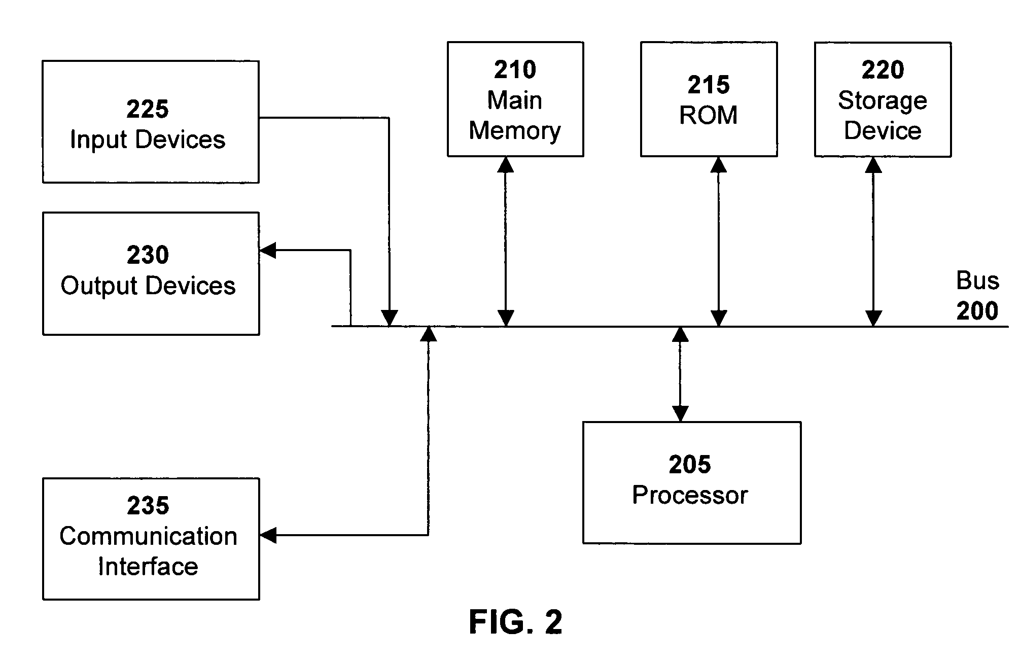
[0027]The functionality described herein may be implemented by computer program instructions. These instructions can be loaded into a computer or other processing environment to produce a machine, such that the instructions are executed to carry out tile-based mapping techniques in accordance with various embodiments of the present invention. These computer progra...
PUM
Abstract
Digital tile-based mapping techniques are disclosed that enable efficient online serving of aesthetically pleasing maps. In one particular embodiment, an image tile-based digital mapping system is configured for generating map tiles during an offline session, and serving selected sets of those tiles to a client when requested. Also provided are solutions for handling map labels and other such features in a tile-based mapping system, such as when a map label crosses map tile boundaries. Various processing environments (e.g., servers or other computing devices) can be employed in the system.
Description
RELATED APPLICATIONS[0001]This application claims the benefit of U.S. Provisional Application Nos. 60 / 650,840, filed Feb. 7, 2005, 60 / 567,946, filed May 3, 2004, and 60 / 555,501, filed Mar. 23, 2004. In addition, this application is a continuation-in-part of U.S. application Ser. No. 11 / 051,534, filed Feb. 5, 2005, titled “A Digital Mapping System.” In addition, this application is related to U.S. application Ser. No.11 / 088,677, filed Mar. 23, 2005, titled “Generating, Storing, and Displaying Graphics Using Sub-Pixel Bitmaps.” Each of these applications is herein incorporated in its entirety by reference.FIELD OF THE INVENTION[0002]The invention relates to mapping systems, and more particularly, to mapping systems in a digital environment.BACKGROUND OF THE INVENTION[0003]Computerized mapping systems have been developed to search for, identify, and discover information about geographic locations. One form of such computerized mapping systems includes travel-planning Internet websites....
Claims
Application Information
Patent Timeline
Application Date:The date an application was filed.
Publication Date:The date a patent or application was officially published.
First Publication Date:The earliest publication date of a patent with the same application number.
Issue Date:Publication date of the patent grant document.
PCT Entry Date:The Entry date of PCT National Phase.
Estimated Expiry Date:The statutory expiry date of a patent right according to the Patent Law, and it is the longest term of protection that the patent right can achieve without the termination of the patent right due to other reasons(Term extension factor has been taken into account ).
Invalid Date:Actual expiry date is based on effective date or publication date of legal transaction data of invalid patent.