Semi-automatic extraction of linear features from image data

Active Publication Date: 2010-01-26
MAXAR INTELLIGENCE INC
View PDF1 Cites 58 Cited by
  • Summary
  • Abstract
  • Description
  • Claims
  • Application Information

AI Technical Summary

Problems solved by technology

However, the prior art methods have been limited to a specific type of imagery such that methods useful for multispectral imagery would not have worked well on radar imagery, panchromatic, or hyperspectral imagery.
Indeed, it is not known whether hyperspectral imagery has even been used for linear feature extraction, since its applications have been primarily limited to agricultural ground use, detection and identification of military targets, ocean and forestry observation, and oil, gas, and mineral exploration.
Even given a particular type of imagery, the prior art methods have serious drawbacks.
With respect to multispectral imagery, automatic methods for extracting road features

Method used


Image

  • Semi-automatic extraction of linear features from image data
  • Semi-automatic extraction of linear features from image data
  • Semi-automatic extraction of linear features from image data

Examples


Embodiment Construction

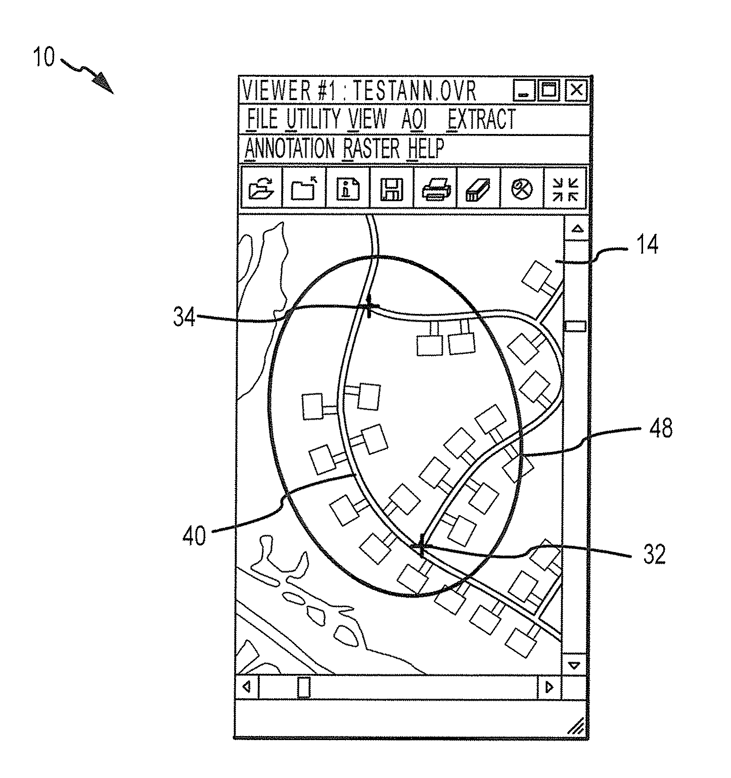
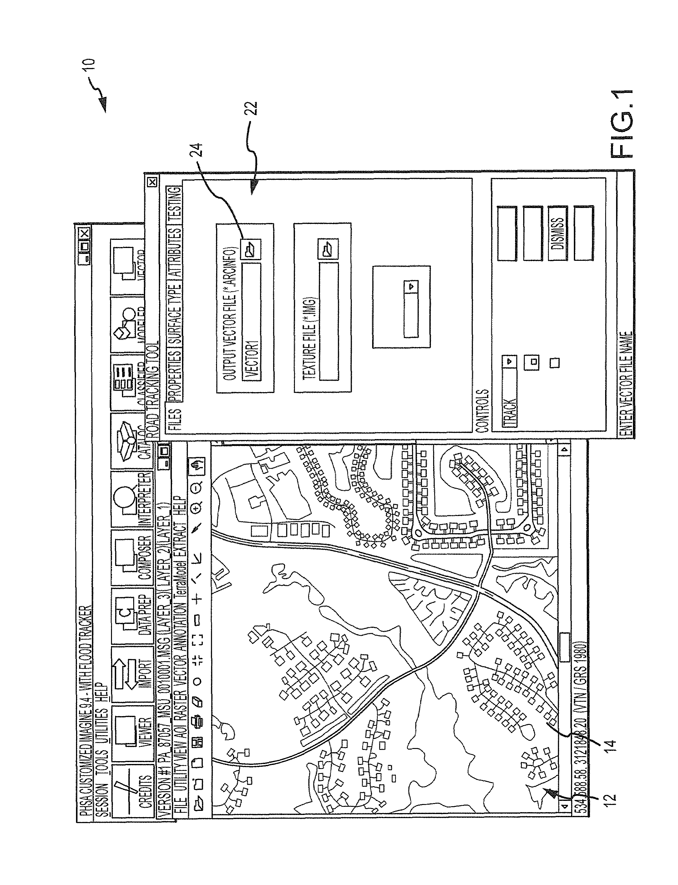
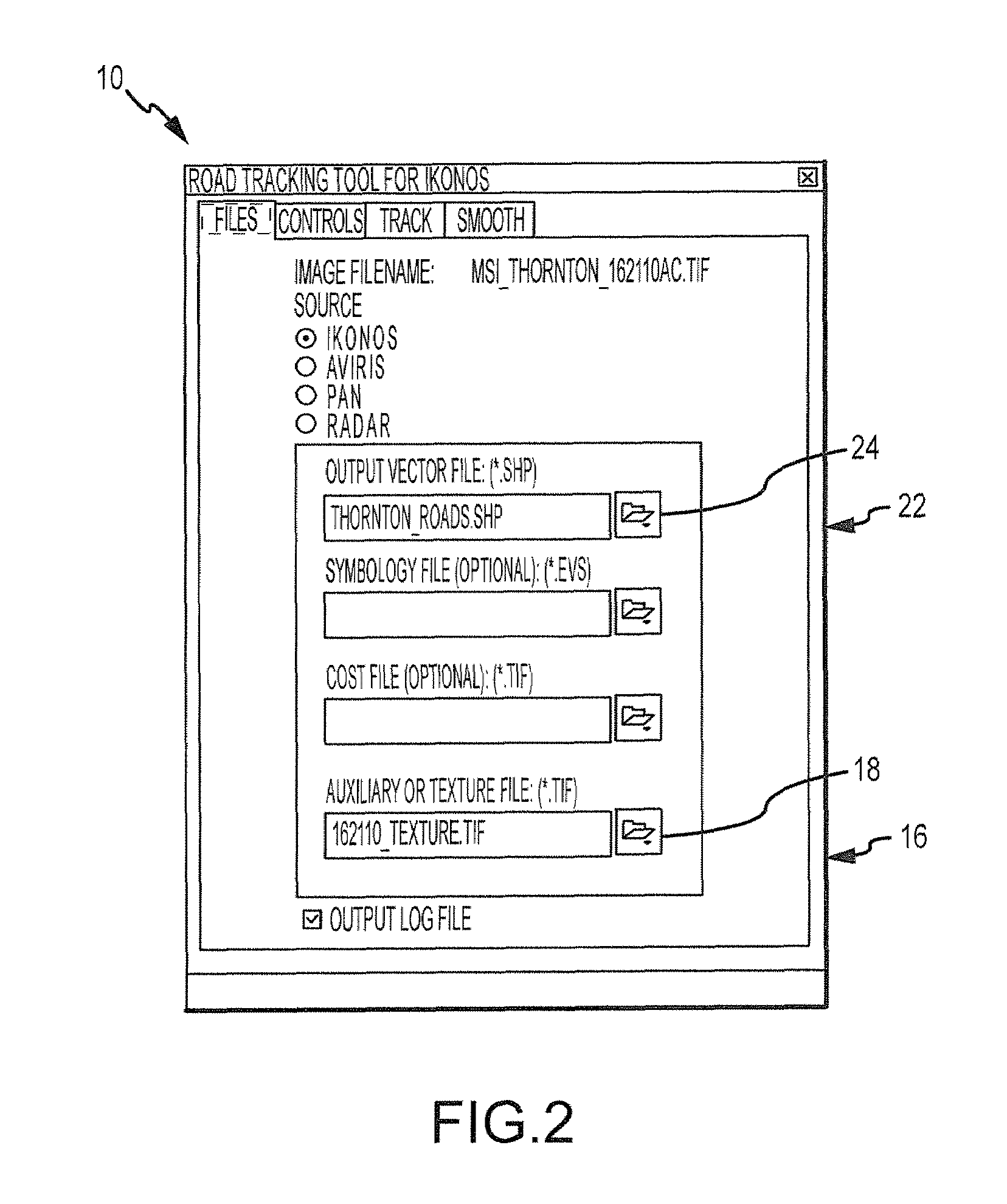
[0096]Broadly described, a method 10 of the present invention comprises extracting at least one linear feature from remotely-sensed imagery. As used herein, “remotely-sensed imagery” is satellite or aerial imagery of a geographic location that measures reflected or emitted radiation in spectral bands ranging from ultraviolet to infrared on the electromagnetic spectrum, and maintains spatial data in a raster GIS format. A “multispectral image” is an image collected in multiple bands ranging from ultraviolet to infrared. A “panchromatic image” is an image collected in the broad visual wavelength range (plus near-infrared) but rendered in black and white. As used herein, “radar imagery” is imagery produced by illuminating a geographic area with microwaves and measuring and recording the strength and travel time of the received signals or the transmitted and received signals. Radar imagery includes but is not limited to imagery produced from real aperture and synthetic aperture radar (S...


PUM


Abstract

A method for extracting a linear feature from remotely sensed imagery, including selecting by user interface anchor points for the linear feature, the anchor points being identified with a geographic location; using image-based logic to automatically calculate a vector set associated with the anchor points, the vector set comprising a path associated with the linear feature; automatically attributing a material type to the path; automatically attributing a geometry to the path; selecting by user interface anchor points for a successive linear feature; using image-based logic to calculate a successive vector set associated with the anchor points for the successive linear feature, the successive vector set comprising a successive path; using a geometric relationship between the vector set and the successive vector set to automatically adjust the vector set to create an adjusted vector set, the adjusted vector set correcting the path associated with the first linear feature.

Description

CROSS REFERENCE TO RELATED APPLICATIONS[0001]This application is a continuation-in-part of nonprovisional application Ser. No. 11 / 416,276, filed May 2, 2006, and also a continuation-in-part of nonprovisional application Ser. No. 11 / 416,282, filed May 2, 2006. Both of these aforementioned parent applications are incorporated herein for all that they disclose.FIELD OF INVENTION[0002]This invention relates generally to the field of geospatial analysis and specifically to extracting features of remotely-sensed image data.BACKGROUND[0003]Geographic information systems (GIS), including remotely-sensed imagery from satellites and aircraft, have revolutionized mapping. To the naked eye, while this imagery may appear to be merely an aerial view of a particular location captured at a particular point in time, there is significant spatial data associated with the imagery.[0004]Spatial data associated with such imagery may be stored, manipulated and displayed in a raster layer. Each GIS image i...

Claims


Application Information

Patent Timeline
IPC IPC(8): G06K9/62G06V20/13
CPCG06K9/0063G06V20/13
Inventor MALITZ, SETH M.POULSEN, RICHARDGRODECKI, JACEK FRANCISZEKLUTES, JAMES ANTHONYBERGEN, ZACHARY
Owner MAXAR INTELLIGENCE INC
Why Eureka
Try Eureka