Supporting an assisted satellite based positioning

a satellite and positioning technology, applied in satellite radio beaconing, measurement devices, instruments, etc., can solve the problems of limiting the propagation time of satellite signals and the occurring doppler frequency, all protocols have a high dependency on gps, and cannot be suitable for actual accurate positioning, so as to reduce the amount of data that has to be transferred between a communication network and a mobile arrangement, extend the life span of long-term orbital parameters, and enhance the accuracy and integrity of long-term orbi

Active Publication Date: 2010-04-20
NOKIA TECHNOLOGLES OY
View PDF21 Cites 16 Cited by
  • Summary
  • Abstract
  • Description
  • Claims
  • Application Information

AI Technical Summary

Benefits of technology

[0031]It is an advantage of the first aspect of the disclosure that the same orbit model can be used for the assistance data of various satellite based positioning systems. With the common orbit model, a similar performance in terms of accuracy can be achieved for all supported satellite based positioning systems. Also new satellite based positioning systems can be added easily. Thus, assisted positioning like A-GNSS could be harmonized in various communication standards, for instance in all cellular standards. In the mobile arrangements, the common orbit model facilitates moreover a hybridization, for example a Galileo-GPS hybridization which allows a mobile arrangement basing positioning calculations on satellite signals of GPS satellites and Galileo satellites. It is also possible to use the common orbit model as a single orbit model for a particular satellite based positioning system, for instance instead of the GPS ephemeris and almanac model, and equally as a single orbit model for all positioning modes, for instance for mobile station assisted GNSS and mobile station based GNSS. Using a common orbit model thus reduces the number of data elements that have to be supported in the communication standards. The size and complexity of a positioning software in a mobile arrangement can be minimized when using the common orbit model in a mobile arrangement, possibly for a hybrid GPS / Galileo receiver, that dispenses with a standalone positioning. That is, in case the mobile arrangement itself does not have any software for decoding satellite navigation data, but only software supporting the proposed common orbit model, even though this is not a preferred embodiment. The same common orbit model could even be used in addition for providing assistance data for terrestrial positioning systems.
[0081]The proposed correction data thus allows enhancing the accuracy and the integrity of long-term orbit models. As the orbit model updates have to be less frequent with accurate correction data, the amount of data that has to be transferred between a communication network and a mobile arrangement is reduced and the load on the bandwidth is lowered. Also the correction models can be more accurate and long-term than existing models. Due to the nature of selective availability, DGPS corrections, for example, were initially developed to be very short-term corrections and not very accurate. Because selective availability is nowadays turned off, a new type of DGPS correction can be designed to be very accurate. Further, a single format of correction data can be used for all satellite constellations, like GPS, Galileo, Glonass, etc.

Problems solved by technology

Almanac parameters, in contrast, can be used for a coarse satellite positioning even for weeks, but they are not suitable for the actual accurate positioning due to the poor accuracy resulting from the long-term fit and also from a smaller number of parameters.
If the assistance data comprises a reference position and ephemeris data for a particular satellite, for example, the GPS receiver may determine the approximate satellite position and motion and thus limit the possible propagation time of the satellite signal and the occurring Doppler frequency.
Further, all protocols have a high dependency on GPS.
Thus, they have also the same limitations and expected accuracy as the ephemeris and almanac data which is broadcast by the satellites.
Moreover, the acquisition assistance is tailor-made for GPS only and cannot be used for position calculation in the mobile station according to all cellular protocols.
However, while there are many common features in all of the GPS related cellular protocols, there are also differences.
A further problem is that in order to use the ephemeris or almanac parameters for predicting accurately the expected satellite code phases and Doppler frequencies in the GPS receiver for the initial signal acquisition, the assistance data from the network has to also include an accurate GPS TOW assistance.
LMUs, however, are expensive and require a continuous maintenance.
In this case, simultaneous assistance data updating is not possible but assistance data updates need to be scheduled independently for Galileo and GPS.
Thus, there are various problems with the current GPS assistance data.
With this solution, GPS and Galileo assistance data would still be restricted to the limitations of the current GPS ephemeris and almanac data, and also a GPS TOW delivery is still required.

Method used


Image

  • Supporting an assisted satellite based positioning
  • Supporting an assisted satellite based positioning
  • Supporting an assisted satellite based positioning

Examples


Embodiment Construction

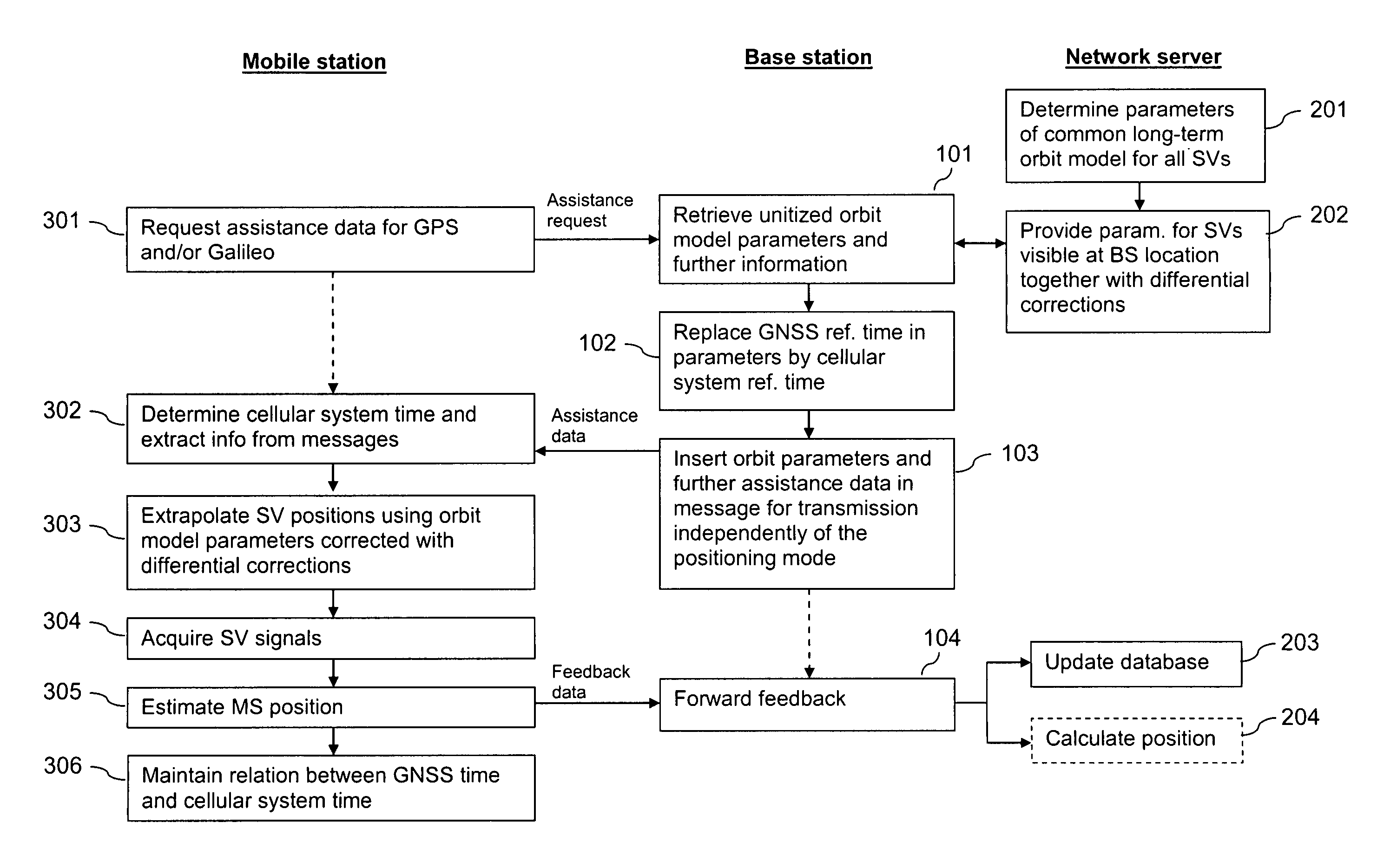
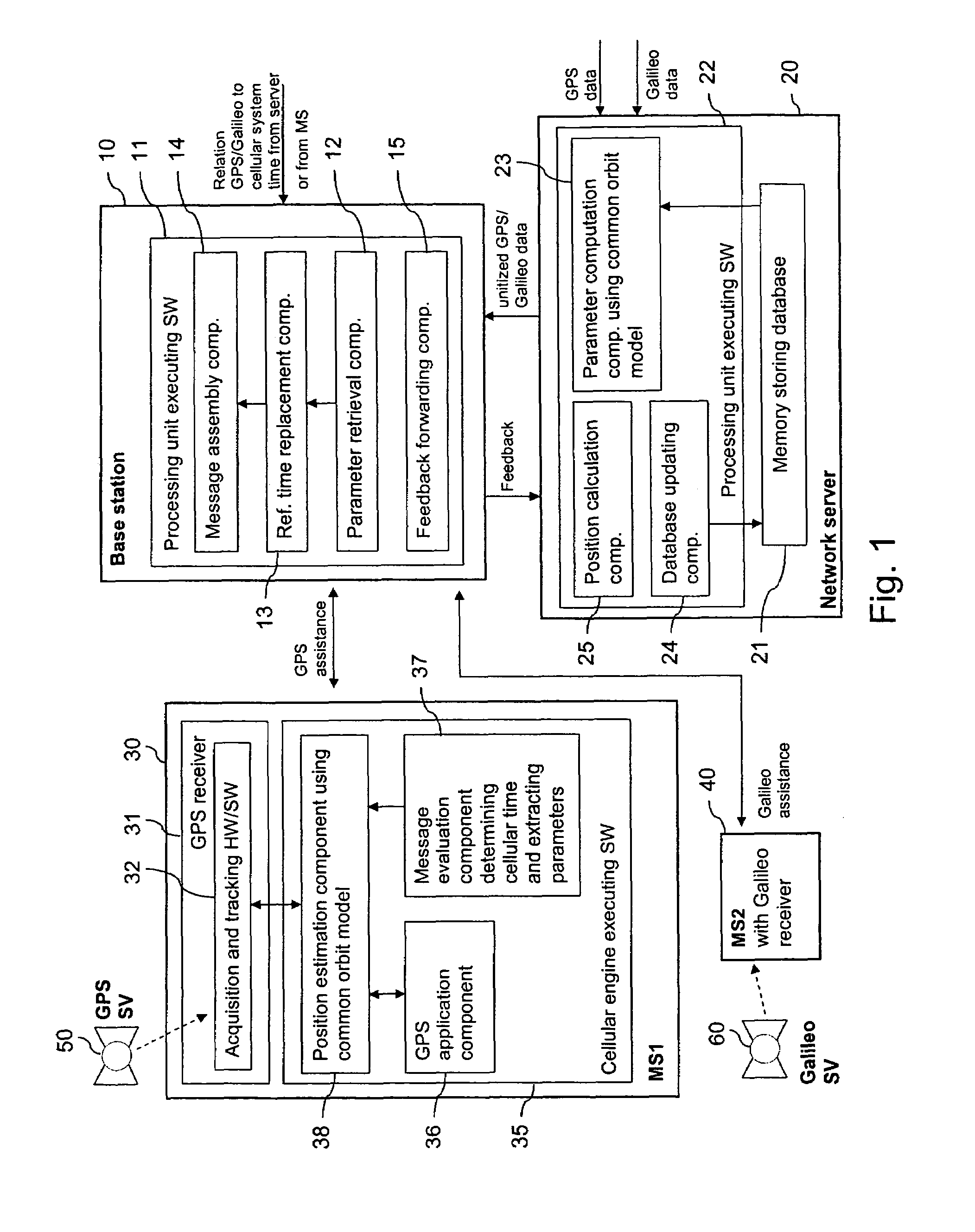
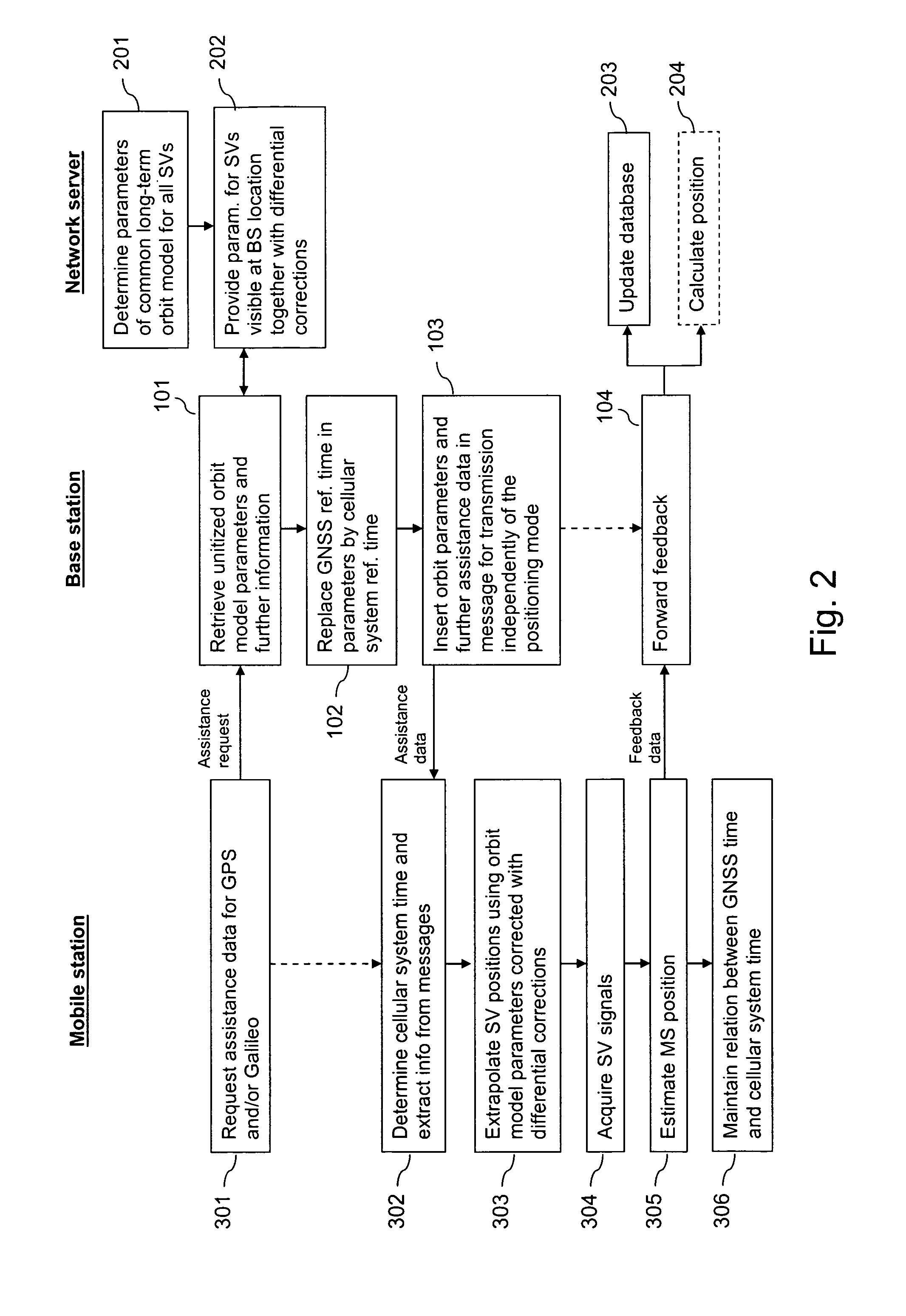
[0091]FIG. 1 is a schematic block diagram of a system supporting A-GNSS in accordance with an embodiment. The system avoids the necessity of providing GNSS time as assistance data and unitizes the provision of assistance data.

[0092]The system comprises a base station 10 and a network server 20 of a GSM network or of any other cellular communication network. The system further comprises a first mobile station (MS1) 30, a second mobile station (MS2) 40, GPS satellites (GPS SV) 50 and Galileo satellites (GPS SV) 60.

[0093]The base station 10 provides a radio interface to mobile stations 30, 40 located in its vicinity. It comprises a processing unit 11 that is able to execute various implemented software code components, including a parameter retrieval component 12, a reference time replacement component 13, a message assembly component 14 and a feedback forwarding component 15.

[0094]The network server 20 can be accessed by various base stations 10 of the cellular communication network. ...


PUM


Abstract

For supporting a satellite based positioning of a mobile arrangement (30,40) with assistance data, a communication network converts parameters of a dedicated orbit model describing a movement of a satellite (50,60), which dedicated orbit model is defined for a particular satellite based positioning system, into parameters of a common orbit model describing a movement of a satellite (50,60). Alternatively or in addition, the network replaces a reference value that is based on a satellite based positioning system time in available parameters of an orbit model by a reference value that is based on a communication system time. After the parameter conversion and / or the reference value replacement, the parameters are provided as a part of assistance data for the satellite based positioning. Alternatively or in addition, a set of data is transmitted in one direction between the mobile arrangement and the communication network, which is independent of the employed positioning mode.

Description

CROSS-REFERENCE TO RELATED APPLICATION[0001]This application is a continuation of International Application Serial No. PCT / IB2005 / 001638 filed Jun. 13, 2005.TECHNICAL FIELD[0002]Methods are shown for supporting a satellite based positioning of a mobile arrangement with assistance data and using assistance data. The invention relates equally to an apparatus supporting a satellite based positioning of a mobile device with assistance data and to apparatus supporting a satellite based positioning of the mobile arrangement using assistance data. The invention relates equally to corresponding software codes and to corresponding software program products.BACKGROUND[0003]Currently there are two operating satellite based positioning systems, the American system GPS (Global Positioning System) and the Russian system GLONASS (Global Orbiting Navigation Satellite System). In the future, there will be moreover a European system called GALILEO. A general term for these systems is GNSS (Global Nav...

Claims


Application Information

Patent Timeline
Patent Type & Authority Patents(United States)
IPC IPC(8): G01S5/14G01S19/24G01S19/37
CPCG01S19/05G01S19/33G01S19/07G01S19/258G01S19/074G01S19/071
Inventor SYRJARINNE, JARI
Owner NOKIA TECHNOLOGLES OY
Why Eureka
Try Eureka