Flight management systems and methods for use with an aerial vehicle

a flight management system and aerial vehicle technology, applied in the field of flight management systems and methods, can solve the problems of distracting the pilot, flight path or navigational indicator generated before the aircraft taxies down the runway and lifts off into the air, and limited practical use during take-off, so as to improve the display of flight paths

Inactive Publication Date: 2011-01-11
HONEYWELL INT INC
View PDF33 Cites 37 Cited by
  • Summary
  • Abstract
  • Description
  • Claims
  • Application Information

AI Technical Summary

Benefits of technology

[0011]Systems and methods according to the foregoing aspects of the invention are advantageous insofar as they reduce pilot distraction and decrease chance of pilot error, among other benefits. Thus, for example, a flight management system as described above can display a flexible HITS flight path during aircraft take-off and, particularly, as the craft turns during climb-out. If the pilot encounters conflicting traffic and temporarily stops the turn or is otherwise delayed in reaching his first waypoint (or other destination), the flight management system continually updates the flexible HITS display, calculating a successive series of best routings from the craft's changing location to the first waypoint (or other destination). This saves the pilot from having to repeatedly reprogram the flight management system during the climb-out procedure in order to find the best path to the waypoint (or other destination). To maintain safety, the flight management system switches to a fixed HITS display when the craft (i) reaches the waypoint (or other destination)—or comes within a predetermined distance of and / or bearing to that waypoint (or other destination), and / or (ii) flight conditions, geography, air traffic, air space restrictions, the craft's performance capabilities or other conditions dictate (for safety or other reasons) that the flight management system switch from the first to the second mode (i.e., from flexible to a fixed HITS display).

Problems solved by technology

A problem with prior art systems is that they have limited practical use during take-off.
For example, it is quite common that a flight path or navigational indicator generated before the aircraft taxies down the runway and lifts off into the air will not be useful after take-off, when the craft's location, heading and altitude have changed.
Re-programming this information whether during take-off or otherwise can, among other things, distract the pilot and increase the chance for pilot error.

Method used


Image

  • Flight management systems and methods for use with an aerial vehicle
  • Flight management systems and methods for use with an aerial vehicle
  • Flight management systems and methods for use with an aerial vehicle

Examples


Embodiment Construction

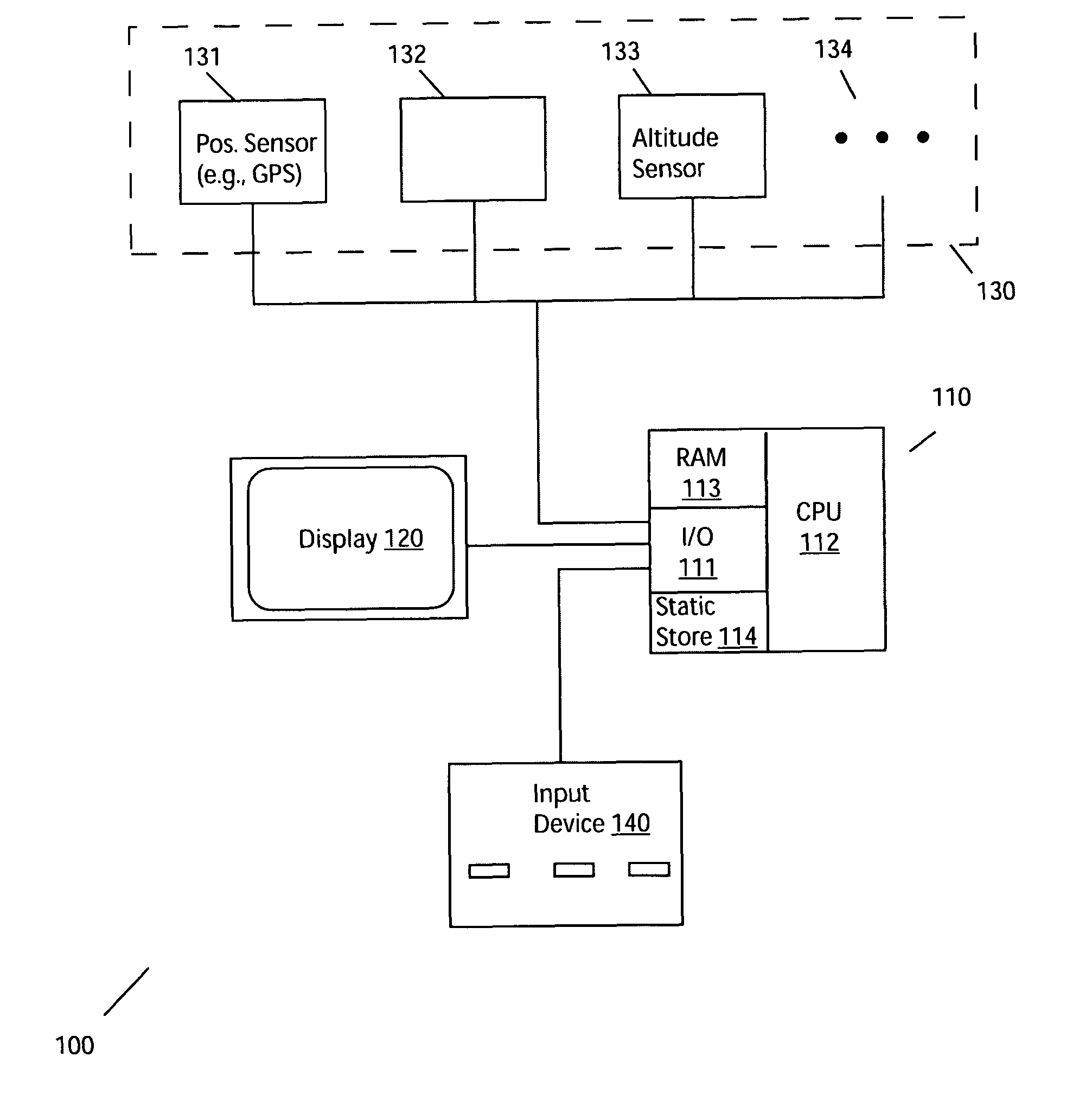
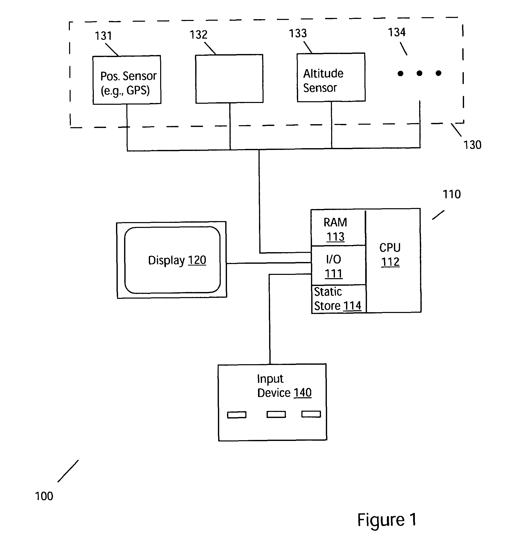
[0027]FIG. 1 depicts an exemplary navigational system for use in an aircraft according to one practice of the invention. The system 100 includes a display 120 coupled to a processing unit 110, both constructed and operated in accord with flight navigational systems known in the art (for example, in accord with the VistaNav™ multifunction flight display, sold by the assignee hereof, Mercury Computer Systems Inc., of Chelmsford, Mass.)—albeit as adapted in accord with the teachings hereof.

[0028]Illustrated processing unit 110 comprises an input / output (I / O) section 111, a central processing unit (CPU) 112, dynamic memory (RAM) 113 and a static store 114, all constructed, interconnected and operated in the conventional manner of general purpose and / or embedded digital data processing devices used in flight management systems known in the art—again, as adapted in accord with the teachings hereof.

[0029]Static store 114 comprises a CD-ROM, DVD, hard disk and / or other long-term storage dev...


PUM


Abstract

The invention provides, in some aspects, flight management systems and methods that generate three-dimensional (3D) graphical representations of airspace in a vicinity of an aircraft (e.g., in flight or during take-off). Such systems can include a display and a processor that drives the display to generate a two-dimensional (2D) or three-dimensional (3D) depiction of flight path. In a first mode, the processor drives the display to generate a flexible highway-in-the-sky (HITS) fight path having an endpoint that is fixed to a destination and having an origin that moves relative to a current location of the aerial vehicle (e.g., a path that “stays” with the vehicle). In a second mode, the processor drives the display to generate a depiction of a fixed HITS flight path that is fixed as to origin and destination and that does not move relative to the craft.

Description

BACKGROUND OF THE INVENTION[0001]The present application pertains to flight management systems and methods, and, more particularly, to improved systems and methods for cockpit display of flight route information. Such systems and methods can be used, by way of example, for enhanced display of flight paths and navigational indicators, e.g., during take-off.[0002]Flight management systems facilitate an aircraft pilot's duties by displaying flight paths and / or other navigational indicators directing the pilot to a pre-selected destination or waypoint. Typical prior art systems allow a pilot to key in or otherwise input a destination location (e.g., “DTW ILS RWY 22L,” indicating the Detroit airport, ILS approach to runway 22L) and one or more waypoints (e.g., “LWM-VOR,” indicating the visual omnirange beacon in Lawrence, Mass.). Usually, the pilot enters that information before taxiing the aircraft for take-off. The systems use the information, along with positional data from an on-boar...

Claims


Application Information

Patent Timeline
Patent Type & Authority Patents(United States)
IPC IPC(8): G01C21/00
CPCG01C23/005
Inventor SIMON, JEFFREY M.
Owner HONEYWELL INT INC
Why Eureka
Try Eureka