Distance dependent error mitigation in real-time kinematic (RTK) positioning

a real-time kinematic and distance-dependent technology, applied in the field of positioning system technology, can solve the problems of increasing the difficulty of reliable ambiguity resolution, unable to solve residual biases or errors after double-differencing, and the problem of ignoring residual biases or errors for ambiguity resolution

Active Publication Date: 2012-08-14
DEERE & CO
View PDF11 Cites 34 Cited by
  • Summary
  • Abstract
  • Description
  • Claims
  • Application Information

AI Technical Summary

Benefits of technology

[0012]The estimation of the atmospheric error sources limits the distance dependent errors of the GPS RTK systems and allows for longer-range applications with precise position estimates.

Problems solved by technology

These ranges are usually referred to as pseudoranges because the GPS measurements may include errors due to various error factors, such as satellite clock timing error, ephemeris error, ionospheric and tropospheric refraction effects, receiver tracking noise and multipath error, etc.
As the receiver separation (i.e., the distance between a reference receiver and a mobile receiver whose position is being determined) increases, the problem of accounting for distance-dependent biases grows and, as a consequence, reliable ambiguity resolution becomes an even greater challenge.
The major challenge is that the residual biases or errors after double-differencing can only be neglected for ambiguity resolution purposes when the distance between the two receivers is less than about 10 km.
For longer distances the distance-dependent errors, such as orbital error and ionospheric and tropospheric delays, become significant problems.
Determining how long the observation span should be to obtain reliable ambiguity resolution is a challenge for GPS RTK positioning.
The longer the observation span that is required, the longer the “dead” time during which precise positioning is not possible.
The quality control and validation criterion for ambiguity resolution represents a significant challenge to precise GPS RTK positioning.

Method used


Image

  • Distance dependent error mitigation in real-time kinematic (RTK) positioning
  • Distance dependent error mitigation in real-time kinematic (RTK) positioning
  • Distance dependent error mitigation in real-time kinematic (RTK) positioning

Examples


Embodiment Construction

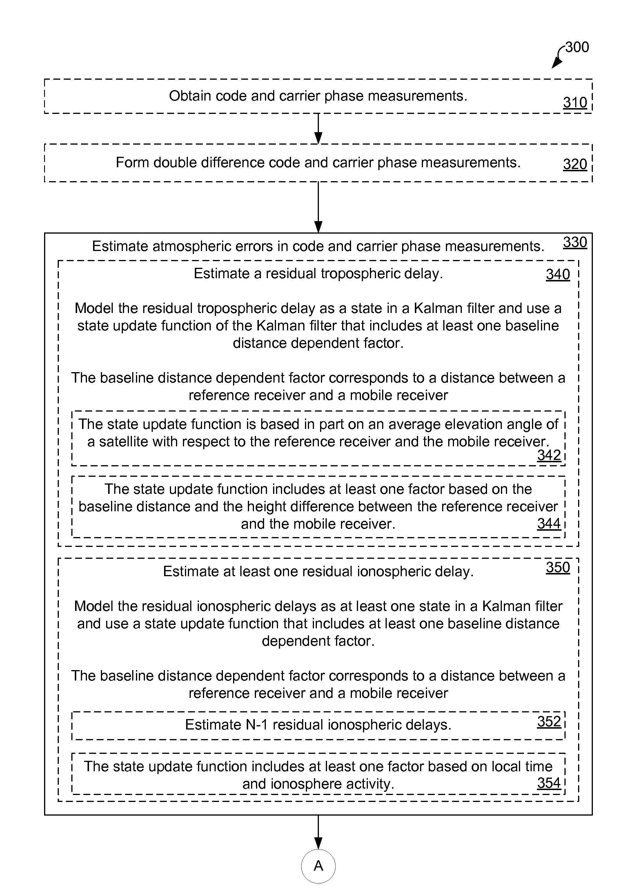
[0009]A method for mitigating distance dependent atmospheric errors in code and carrier phase measurements includes estimating a residual tropospheric delay, a plurality of residual ionospheric delays and an ambiguity value. An estimated position of a mobile receiver is then updated in accordance with these estimates.

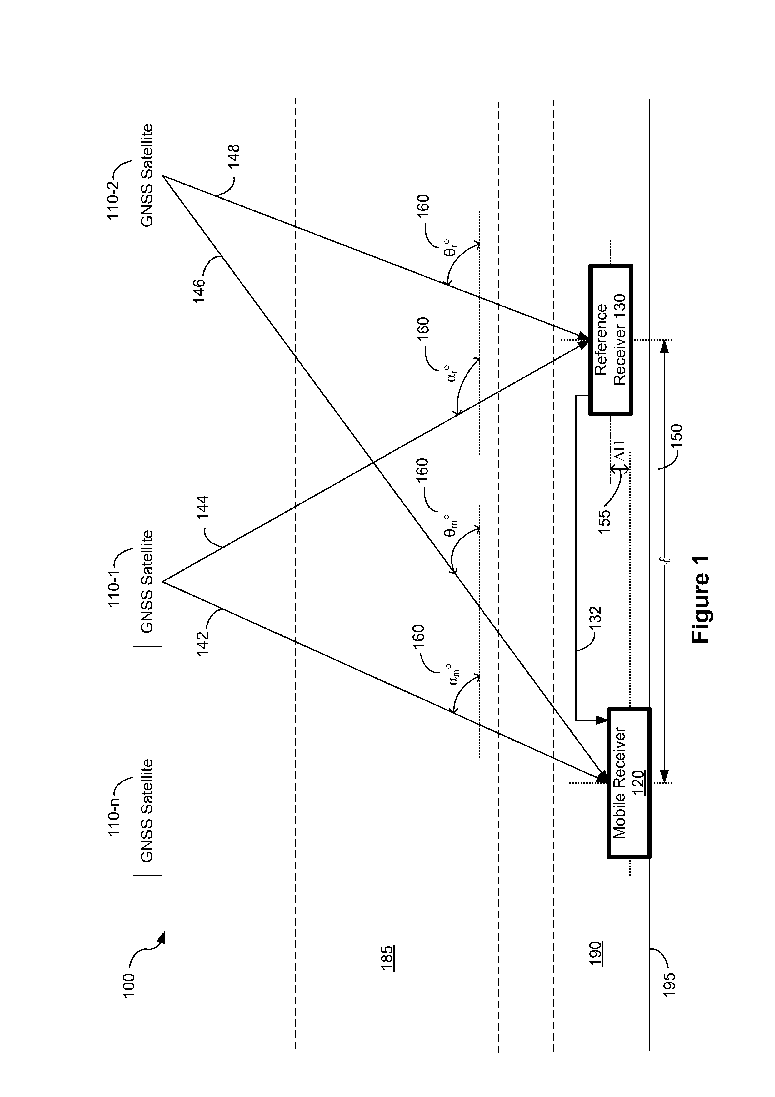
[0010]In one embodiment, a residual tropospheric delay is modeled as a state in a Kalman filter. In one embodiment, a plurality of residual ionospheric delays are modeled as states in a Kalman filter. The state update functions of the Kalman filter include at least one baseline distance dependent factor. The baseline distance dependent factor corresponds to a distance between a reference receiver and a mobile receiver.

[0011]In one embodiment a plurality of ambiguity values are stored in a plurality of states in the Kalman filter. These states are then updated in accordance with a state update function that includes at least one dynamic noise factor.

[0012]The estimation ...


PUM


Abstract

A method for mitigating atmospheric errors in code and carrier phase measurements based on signals received from a plurality of satellites in a global navigation satellite system is disclosed. A residual tropospheric delay and a plurality of residual ionospheric delays are modeled as states in a Kalman filter. The state update functions of the Kalman filter include at least one baseline distance dependant factor, wherein the baseline distance is the distance between a reference receiver and a mobile receiver. A plurality of ambiguity values are modeled as states in the Kalman filter. The state update function of the Kalman filter for the ambiguity states includes a dynamic noise factor. An estimated position of mobile receiver is updated in accordance with the residual tropospheric delay, the plurality of residual ionospheric delays and / or the plurality of ambiguity values.

Description

RELATED APPLICATIONS[0001]This application is a continuation of U.S. patent application Ser. No. 12 / 119,451, filed May 12, 2008 , now U.S. Pat. No. 8,035,552 which claimed priority to U.S. Provisional Application No. 60 / 941,273, filed May 31, 2007, “Distance Dependent Error Mitigation in Real-Time Kinematic (RTK) Positioning,” which is incorporated by reference herein in its entirety.[0002]This application is related to U.S. patent application Ser. No. 12 / 119,450, filed May 12, 2008, “Partial Search Carrier-Phase Integer Ambiguity Resolution,” issued as U.S. Pat. No. 7,961,143, which application is incorporated by reference herein in its entirety.TECHNICAL FIELD[0003]The disclosed embodiments relate generally to technologies associated with positioning systems, such as the Global Positioning System (GPS) or the European Galileo System, and more particularly to methods of mitigating atmospheric errors in code and carrier phase measurements.BACKGROUND[0004]A wide-area positioning syst...

Claims


Application Information

Patent Timeline
Patent Type & Authority Patents(United States)
IPC IPC(8): G01S19/41G01S19/43G01S5/14G01S19/32G01S19/44G01S19/48
CPCG01S19/32G01S19/44
Inventor DAI, LIWEN L.ESLINGER, DANIEL J.SHARPE, RICHARD T.HATCH, RONALD R.
Owner DEERE & CO
Why Eureka
Try Eureka