System and method for multi-resolution routing

a multi-resolution routing and routing system technology, applied in the field of navigation, can solve the problems of reducing computation time and memory usage, and achieve the effect of efficient generation of on- and off-road travel routes

Active Publication Date: 2013-02-12
POLARIS IND INC
View PDF41 Cites 9 Cited by
  • Summary
  • Abstract
  • Description
  • Claims
  • Application Information

AI Technical Summary

Benefits of technology

[0009]The present invention is a computer-implemented method for efficiently generating on- and off-road travel routes using multi-resolution maps. An exemplary embodiment of the invention includes a map generator, map database, route generator, heuristic generator, and search envelope factor generator.
[0011]An exemplary embodiment of the route generator produces a route at a coarse zoom level and then regenerates the route at progressively higher zoom levels. At these higher zoom levels, the route generator uses the route generated at the previous zoom level to limit the scope of the search at the current zoom level. Specifically, the route generator penalizes candidate routes at the current zoom level that deviate too far from the route generated at the previous zoom level. The result is decreased computation time and memory usage. The route generator uses a well-known, heuristic-based path finding algorithm such as A* to generate the routes.
[0012]An exemplary embodiment of the heuristic generator calculates the heuristic used by the path finding algorithm. At the initial zoom level, the heuristic generator produces a value based on the distance between the current node and the goal node as well as a minimum cost between adjacent nodes. At higher zoom levels, the heuristic generator additionally accounts for a search envelope factor.
[0014]Advantageously, unlike the background art, the present invention is capable of quickly generating high-quality, long off-road routes on resource-constrained platforms. Also, the present invention enables one to make tradeoffs between route quality and computation time / memory usage by narrowing or widening the search envelope. Also, the present invention improves routing at coarse zoom levels by including narrow land cover features that affect routing (e.g. fences, roads, streams, and trails) in all map resolutions.
[0025]The map generator enlarges map features at lower zoom levels to improve routing.

Problems solved by technology

The result is decreased computation time and memory usage.

Method used


Image

  • System and method for multi-resolution routing
  • System and method for multi-resolution routing
  • System and method for multi-resolution routing

Examples


Embodiment Construction

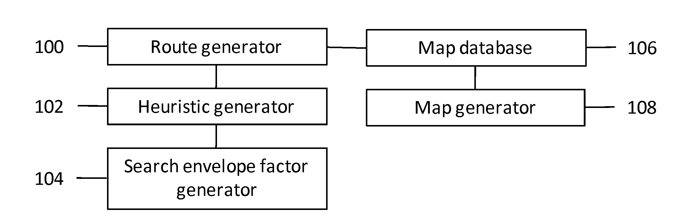
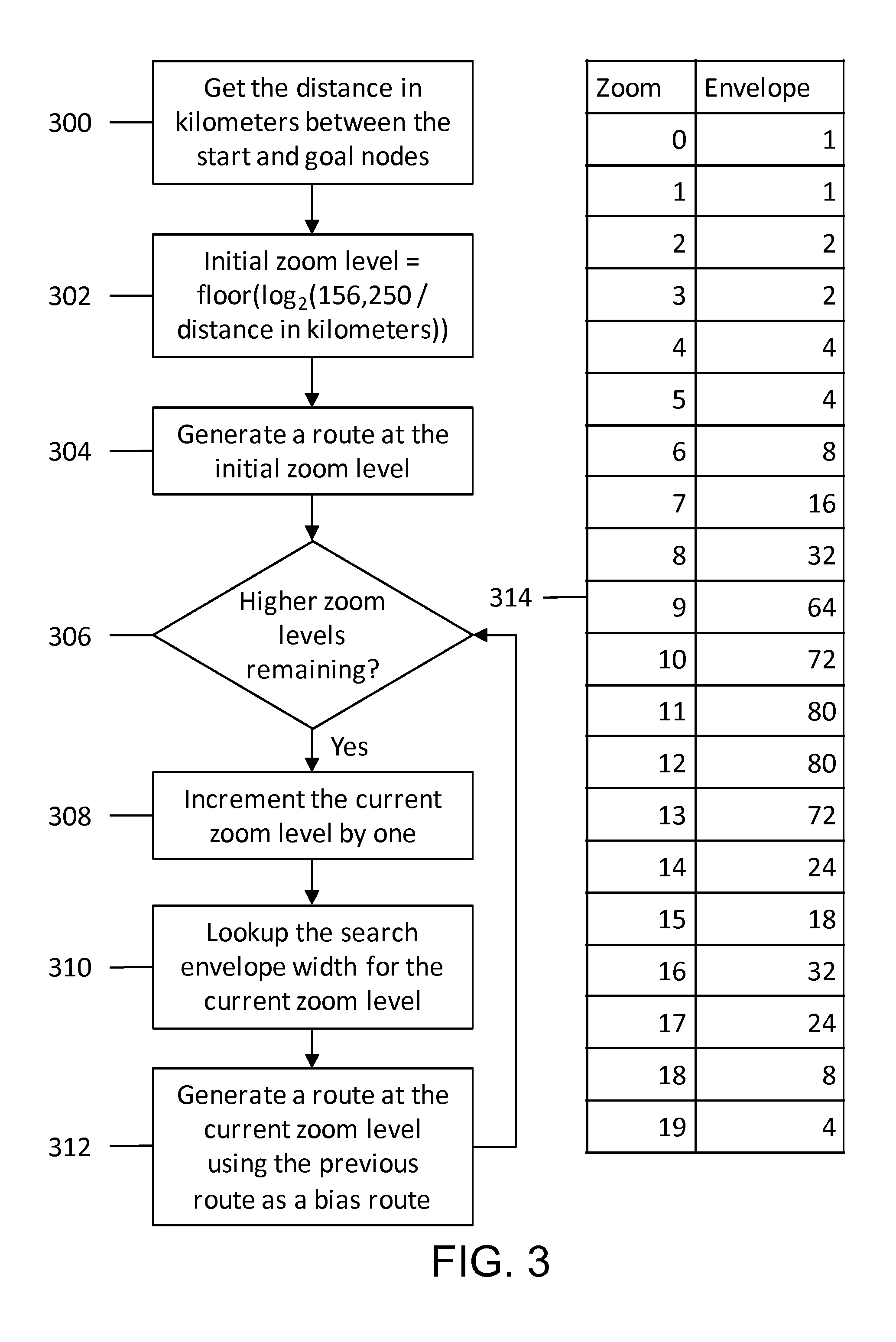
[0040]FIG. 1 shows an exemplary embodiment of the present invention. The map generator 108 converts input raster and vector map data into output multi-resolution raster map data suitable for routing and stores it in the map database 106. The route generator 100 generates a route at a coarse zoom level and then refines it at higher zoom levels, using previous routes to limit the search. The route generator 100 uses a well-known, heuristic-based path finding algorithm such as A*. The heuristic generator 102 produces heuristic values used by the path planning algorithm. At the initial zoom level, the heuristic generator 102 returns values derived from the current node's distance to the goal and a minimum cost between adjacent nodes. At higher zoom levels, the heuristic generator 102 also takes into account a search envelope that penalizes nodes far away from the bias route generated at the previous zoom level. To compute this penalty, the heuristic generator 102 relies on a search enve...


PUM


Abstract

A system, method and computer program product for efficiently generating on- and off-road travel routes using multi-resolution maps including a map generator (108), map database (106), route generator (100), heuristic generator (102), and search envelope factor generator (104). The map generator (108) converts input raster and vector map data into output multi-resolution raster map data suitable for routing and stores it in the map database (106). The route generator (100) uses the map database (106) to produce a route at a coarse zoom level and then regenerate the route at progressively higher zoom levels. The heuristic generator (102) penalizes high resolution routes that deviate too far from one or more low resolution routes. The search envelope factor generator (104) computes this penalty based on the distance from a given search graph node to the low resolution routes.

Description

FIELD OF THE INVENTION[0001]This invention relates to navigation, specifically to efficiently generating on- and off-road travel routes using multi-resolution maps.DISCUSSION OF THE BACKGROUND[0002]U.S. Pat. Nos. 6,963,800 (“Routing soldiers around enemy attacks and battlefield obstructions”) and 7,756,635 (“Method and System for Generating and Presenting Off-Road Travel Routes”) by Randy Milbert pioneered automated off-road route planning. They enabled soldiers and civilians alike to plan routes through any terrain—desert, jungle, mountainous, urban, or woodland—on- or off-road.[0003]Whereas on-road route planning is limited to a relatively sparse graph—one can only go left, right, or straight at a typical intersection—off-road route planning leads to immensely denser graphs because one has 360 degrees of freedom at every point.[0004]An exemplary embodiment described in U.S. Pat. Nos. 6,963,800 and 7,756,635 uses A* (see pages 93 to 99 of “Artificial Intelligence: A Modern Approach...

Claims


Application Information

Patent Timeline
Patent Type & Authority Patents(United States)
IPC IPC(8): G01C21/34
CPCG01C21/20G01C21/3446G01C21/34
Inventor WHITE, DANEFREED, ERIK
Owner POLARIS IND INC
Why Eureka
Try Eureka