Automated floodplain encroachment computation

a floodplain and computation technology, applied in the field of geospatial mapping systems, can solve the problems of inability to provide an efficient mechanism for analyzing floodplains, inability to permit any encroachment construction, and inability to provide floodplain construction efficiency, etc., to reduce the amount of time required by users, reduce the amount of time required, and simplify the workflow

Active Publication Date: 2013-08-13
AUTODESK INC
View PDF15 Cites 0 Cited by
  • Summary
  • Abstract
  • Description
  • Claims
  • Application Information

AI Technical Summary

Benefits of technology

[0025]A graphical user interface (GUI) shows the engineer, in real time, what affect a specified floodplain encroachment has on the river water surface profile. Such an interface allows the engineer to quickly try different alternative encroachments and develop a “best” solution in minimal time. The GUI utilizes the HEC-RAS engine to compute the data analysis in a manner that is transparent to the user. Further, the workflow is simplified, making most data analysis automatic thereby reducing the amount of time required by the user.
[0026]Data (e.g., floodplain, river flow, encroachment data, points of flow, etc.) may be collected at a single point (e.g., a single dialog). Once collected, an analysis can be completed and marked according to however the user elects. Unlike the prior art, the exportation and importation of the data into a GIS system is not necessary or needed and the prior art trial and error methodology that is prone to error is avoided.

Problems solved by technology

The use of the HEC-RAS system is time consuming, labor intensive, and therefore fails to provide an efficient mechanism for analyzing floodplains and encroachments.
However, as stated above, FEMA will often not permit the constructions of any encroachment unless an engineer using HEC-RAS can verify that it will not increase the flood elevation of the base flood more than a designated height (e.g., 1 foot).
However, the paper-based maps are not georeferenced, not current, and must be modernized.
In addition, numerous engineering flood studies are going to be performed to update inadequate and inaccurate previous studies upon which the paper maps are based.
Further, even the alternative partially-automated systems are not integrated with HEC-RAS thereby requiring users to restart their entire mapping process if an error or undesirable results are output from HEC-RAS.
Further, due to the lack of integration, once complete, the user must export any final computations / values back to the GIS system.
However, such a display is in a separate graphical user interface and fails to show the user what encroachment definitions were used to obtain the results displayed.
In other words, if the user forgets the values previously used (or forgets to manually store them), a set of computations may be repeated unnecessarily.
Lastly, there is no mechanism to mark a computation as finished or unfinished.
Such manual efforts significantly slows the floodplain encroachment analysis process and is very inefficient.

Method used


Image

  • Automated floodplain encroachment computation
  • Automated floodplain encroachment computation
  • Automated floodplain encroachment computation

Examples


Embodiment Construction

[0039]In the following description, reference is made to the accompanying drawings which form a part hereof, and which is shown, by way of illustration, several embodiments of the present invention. It is understood that other embodiments may be utilized and structural changes may be made without departing from the scope of the present invention.

Overview

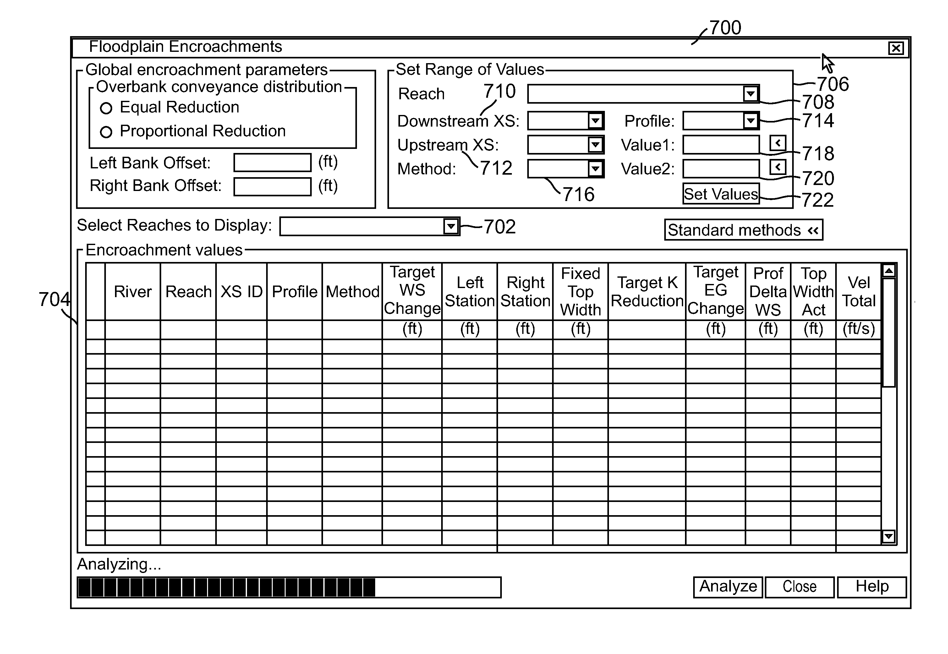
[0040]One or more embodiments of the invention allow an engineer to quickly complete a FEMA floodplain encroachment study when compared to all prior art methods. The workflow greatly simplifies the prior art process that is manual, disjointed, and comprised of several different interfaces. Further, embodiments of the invention provide the ability to compute and view floodplain encroachment data in a single location / interface.

Hardware Environment

[0041]FIG. 6 is an exemplary hardware and software environment 600 used to implement one or more embodiments of the invention. The hardware and software environment includes a computer 602 and...


PUM


Abstract

A method, apparatus, and article of manufacture provide the ability to define a floodplain encroachment. River reach and station information are received into a geographic information system (GIS). Floodplain encroachment values are defined using a graphical user interface (GUI). The GUI provides a simultaneous view of station identifiers for each station for which the floodplain encroachment is to be defined, profiles defined for each of the station identifiers, a method identification corresponding to each of the defined profiles, and a target water surface elevation change for each profile. The values are provided to a HEC-RAS engine which outputs analysis results that are simultaneously displayed in the GUI with the other information. The analysis results include a water surface elevation change, a top width, and a velocity for each profile-station pair. Users can modify the values and dynamically view the results from HEC-RAS in the GUI.

Description

BACKGROUND OF THE INVENTION[0001]1. Field of the Invention[0002]The present invention relates generally to geospatial mapping systems, and in particular, to a method, apparatus, and article of manufacture for computing floodplain encroachments using a geospatial mapping system.[0003]2. Description of the Related Art[0004]A floodplain is a land area (usually adjacent to a stream or river) that is susceptible to being inundated (occasionally or periodically) by flood waters from any source. Due to the high value of land and structures built adjacent to a stream or river, it is desirable to maximize and develop in the floodplain area. A floodplain development that can obstruct flood flows, such as a fill / backfill, a bridge, or a building is referred to as an “encroachment”. Various federal agencies require the purchase of flood insurance (in floodplain areas) and regulate new development for encroachments. As part of the analysis for encroachments, such federal agencies require the use...

Claims


Application Information

Patent Timeline
Patent Type & Authority Patents(United States)
IPC IPC(8): G06F3/048G06F3/01
CPCE03B1/00
Inventor MAEDER, CHRISTOPHER EDWARD
Owner AUTODESK INC
Why Eureka
Try Eureka