GNSS based control for dispensing material from vehicle

a technology for vehicle and material dispensing, applied in process and machine control, instruments, navigation instruments, etc., can solve the problems of inability to accurately determine poi, less than precise production, and inability to take into account the actual curvature of terrain

Active Publication Date: 2014-01-21
AGJUNCTION
View PDF69 Cites 62 Cited by
  • Summary
  • Abstract
  • Description
  • Claims
  • Application Information

AI Technical Summary

Benefits of technology

[0011]Disclosed herein in an exemplary embodiment is a sensor system for vehicle steering control comprising: a plurality of global navigation satellite systems (GNSS) including receivers and antennas at a fixed spacing to determine a vehicle position, velocity and at least one of a heading angle, a pitch angle, and a roll angle based on carrier phase corrected real time kinematic (RTK) position differences. The roll angle facilitates correction of the lateral motion induced position errors resultant from motion of the antennas as the vehicle moves based on an offset to ground and the roll angle. The system also includes a control system configured to receive the vehicle position, heading, and at least one of roll, pitch and yaw, and configured to generate a steering command to a vehicle steering system.
[0016]An additional exemplary embodiment is a sensor system for vehicle guidance using one or more global navigation satellite systems (GNSSs) according to the above-mentioned embodiments, in combination with a plurality of various sensors located throughout a vehicle and a towed implement. These sensors detect additional parameters from those calculated by the GNSS positioning system, such as vehicle and implement stress levels, fuel levels, power levels, optical guide path observations via an onboard camera, multi-section (articulated) implement position and attitude sensing via multiple antennas and other characteristics of the working vehicle. The combination of the two systems results in a much more accurate and economical preplanned path generated for use in later field work.
[0018]Areas to be sprayed are designated as spray zones while areas not to be sprayed are designated as exclusion zones. The spray zones and exclusion zones are separated by linear boundaries, which are surveyed, and coordinates of the boundaries are stored in the controller. The controller is a computer having data storage, data inputs and outputs, and controlled outputs connected to suitable drivers and / or relays to control particular processes or actions. When the spray vehicle is within an exclusion zone and approaching a spray zone, the boundary is termed a spray turn-on boundary. When the spray vehicle is within a spray zone and approaching an exclusion zone, the boundary is termed a spray turn-off boundary. In general, the controller is programmed to control activation of the pump in relation to positions detected by the GNSS receiver to retain the spray of the material within spray zones and to prevent spray of the material within the exclusion zones.

Problems solved by technology

However, in existing satellite positioning systems (SATPS) for guided parallel and contour swathing for precision farming, mining, and the like, the actual curvature of terrain may not be taken into account.
This results in a less than precise production because of the less than precise parallel or contour swathing.
However, if the tractor is on an inclined terrain with a variable tilt, which is often the case, the SATPS alone cannot determine the terrain tilt so the POI also cannot be determined.
This results in a guidance error because the POI is approximated by the point of reception (POR), and this approximation worsens as the terrain inclination increases.
This results in cross track position excursions relative to the vehicle ground track which would contaminate any attempt to guide to a defined field line or swath.
Systems using Doppler radar will encounter errors with the radar and latency.
Similarly, gyroscopes, which may provide heading, roll, or pitch measurements, may be deployed as part of an inertial navigation package, but tend to encounter drift errors and biases and still require some external attitude measurements for gyroscope initialization and drift compensation.
Gyroscopes have good short-term characteristics but undesirable long-term characteristics, especially those gyroscopes of lower cost such as those based on a vibrating resonator.
Similarly, inertial systems employing gyroscopes and accelerometers have good short-term characteristics but also suffer from drift.
Various systems include navigating utilizing GNSS; however, these systems also exhibit disadvantages.
Existing GNSS position computations may include lag times, which may be especially troublesome when, for example, GNSS velocity is used to derive vehicle heading.
Existing GNSS systems do not provide high quality heading information at slower vehicle speeds.
However, accuracy and precision can only improve the efficiency of working vehicles, such as those in the agricultural field, to a limited extent.
Although such systems are able to track and guide vehicles in three dimensions, including along ridges and sloped-regions, errors may appear in other aspects of a working vehicle.
Drilling waste water is one such restricted application.
However, if it is dumped into a surface water shed in large quantities and concentrations, it can have a detrimental effect on local fish populations.
Even with a visually marked boundary of the spray zone, it is difficult for a tanker truck driver to accurately turn the spray on and off to fully cover the spray zone and to prevent some spray from getting in the exclusion zone.

Method used


Image

  • GNSS based control for dispensing material from vehicle
  • GNSS based control for dispensing material from vehicle
  • GNSS based control for dispensing material from vehicle

Examples


Embodiment Construction

[0059]As required, detailed embodiments of the present invention are disclosed herein; however, it is to be understood that the disclosed embodiments are merely exemplary of the invention, which may be embodied in various forms. Therefore, specific structural and functional details disclosed herein are not to be interpreted as limiting, but merely as a basis for the claims and as a representative basis for teaching one skilled in the art to variously employ the present invention in virtually any appropriately detailed structure.

I. GNSS Introduction

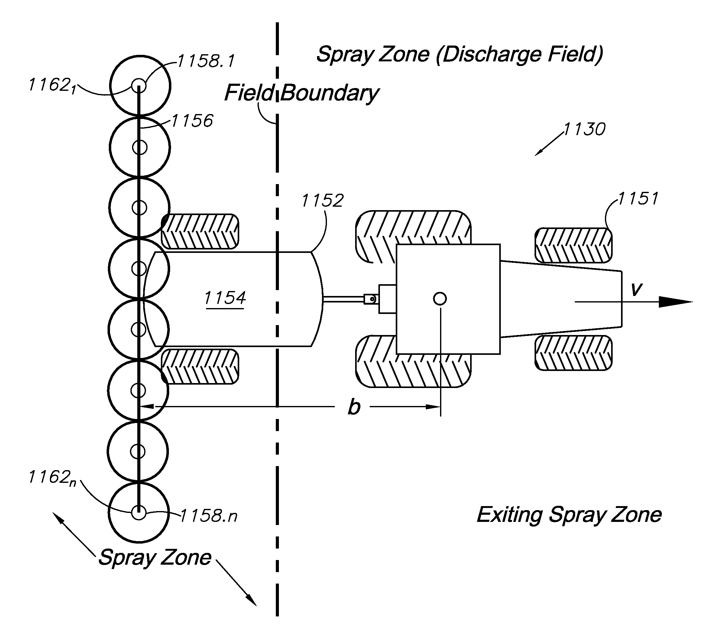
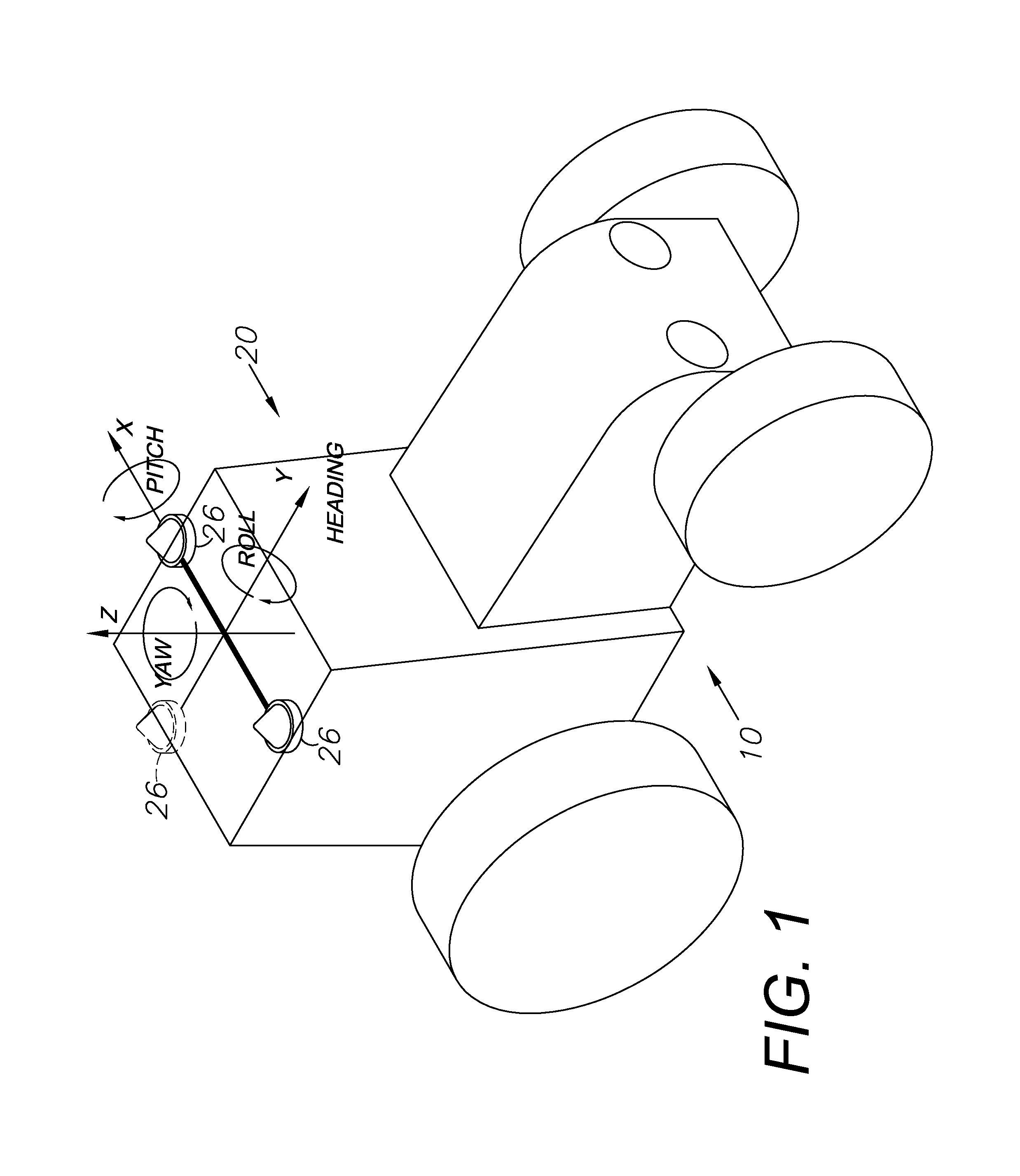
[0060]Global navigation satellite systems (GNSS) are broadly defined to include GPS (U.S.), Galileo (proposed), GLONASS (Russia), Beidou / Compass (China, proposed), IRNSS (India, proposed), QZSS (Japan, proposed) and other current and future positioning technology using signals from satellites, with or without augmentation from terrestrial sources. Inertial navigation systems (INS) include gyroscopic (gyro) sensors, accelerometers and simil...


PUM


Abstract

A spray control method employs a spray vehicle including a material tank, a pump communicating with the tank, and nozzles of a spray boom communicating with the pump. A GNSS receiver mounted on the vehicle and interfaced to a controller tracks its position in relation to stored position coordinates of field boundaries separating spray zones from spray exclusion zones. The tank is activated and deactivated by the controller to retain spray of the material within the spray zones and to prevent spray of the material in the exclusion zones, by processing an offset of the spray nozzles from the receiver, the spray range of the nozzles, spray turn-on and turn-off lag times, and the velocity of the spray vehicle, all in relation to the field boundaries. An alternative embodiment individually controls spray from the nozzles by using associated valves interfaced to the controller.

Description

CROSS-REFERENCE TO RELATED APPLICATIONS[0001]This application is a continuation-in-part of and claims the benefit of: U.S. patent application Ser. No. 12 / 355,776, filed Jan. 17, 2009 now U.S. Pat. No. 8,140,223; which is a continuation-in-part of Ser. No. 12 / 171,399, filed Jul. 11, 2008 now U.S. Pat. No. 8,265,826; which is a continuation-in-part of Ser. No. 10 / 804,758, filed Mar. 19, 2004, now U.S. Pat. No. 7,400,956 and a continuation-in-part of Ser. No. 10 / 828,745, filed Apr. 21, 2004, now abandoned which benefited from U.S. Provisional Patent Application Ser. No. 60 / 456,146, filed Mar. 20, 2003 and Ser. No. 60 / 464,756, filed Apr. 23, 2003. This application is also a continuation-in-part of U.S. patent application Ser. No. 12 / 750,429 filed Mar. 30, 2010 now U.S. Pat. No. 8,214,111; which is a continuation of U.S. patent application Ser. No. 11 / 184, 657, filed Jul. 19, 2005, now U.S. Pat. No. 7,689,354. The contents of all of the aforementioned applications and patents are incorpo...

Claims


Application Information

Patent Timeline
Patent Type & Authority Patents(United States)
IPC IPC(8): G06F19/00B05B12/00
CPCG01S19/04G01S19/54G01S5/0063G01S19/14G01C15/00A01B79/005G05D2201/0201G05D1/0259G05D1/0278G05D1/027
Inventor MCCLURE, JOHN A.STICHTER, AARON C.
Owner AGJUNCTION
Why Eureka
Try Eureka