System and method for self-calibrating, self-organizing and localizing sensors in wireless sensor networks

a wireless sensor and self-organization technology, applied in the field of wireless sensor networks, can solve the problems of gnss-based localization systems that are typically expensive to deploy, devices employing gnss technology are relatively expensive, and gnss typically has limited accuracy in determining position

Inactive Publication Date: 2014-09-30
SIMON FRASER UNIVERSITY
View PDF81 Cites 117 Cited by
  • Summary
  • Abstract
  • Description
  • Claims
  • Application Information

AI Technical Summary

Benefits of technology

[0019]Certain embodiments of the method of self-calibrating a WSN of the present invention may include one or more of the following features. In some embodiments, the method further includes receiving a localized position for a mobile node located between a pair of neighboring sensor nodes, and applying a corresponding translation vector to the localized position to determine a calibrated localization position for the mobile node. In some embodiments, the method further includes repeating the transmitting, measuring and determining operations to account for at least one variation of wireless signal transmission in the WSN. In some embodiments, the method of self-calibrating a WSN eliminates the need for executing a complicated, time-consuming process of manually placing a mobile node or device at multiple locations in the WSN to establish calibration standards, as is typically required in prior art manual system calibration methods.

Problems solved by technology

For example, a GNSS-based localization system is typically expensive to deploy because the devices employing GNSS technology are relatively expensive.
In addition, GNSS typically has limited accuracy in determining position.
In addition, GNSS position localization requires line of sight reception of satellite signals, thus limiting its use to an outdoor environment.
GNSS systems are typically also limited in effectiveness when obstacles block line of sight to satellite positions such as in urban, steep terrain or forested locations.
Furthermore, for certain applications that require high security, GNSS systems may compromise security requirements through their use of public satellite communications.
Moreover, due to satellite communication delay, use of GNSS might not be an effective method for real-time tracking of moving sensors, particularly in some environments where GNSS reception is less than ideal.
Conventional non-GPS-based wireless positioning systems and methods also suffer from various drawbacks.
One significant such drawback is that prior methods are often not suitable for deployment in large-scale networks, as their performance typically deteriorates rapidly as the network increases in size.
The execution times required for sensor system operation and localization may not typically be fast enough for real-time applications, for example.
Disturbances in an environment of interest in which a wireless sensor network is deployed may affect the transmission and / or reception of wireless signals, such as unevenness and geographical obstacles in a terrain.

Method used


Image

  • System and method for self-calibrating, self-organizing and localizing sensors in wireless sensor networks
  • System and method for self-calibrating, self-organizing and localizing sensors in wireless sensor networks
  • System and method for self-calibrating, self-organizing and localizing sensors in wireless sensor networks

Examples


Embodiment Construction

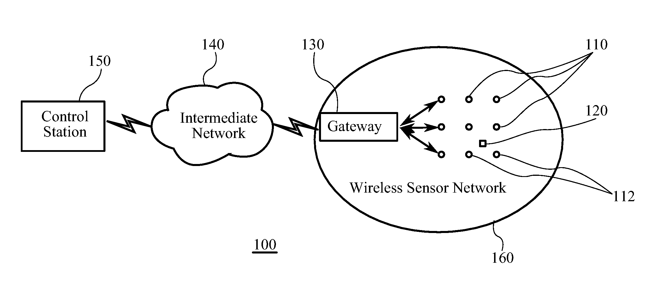
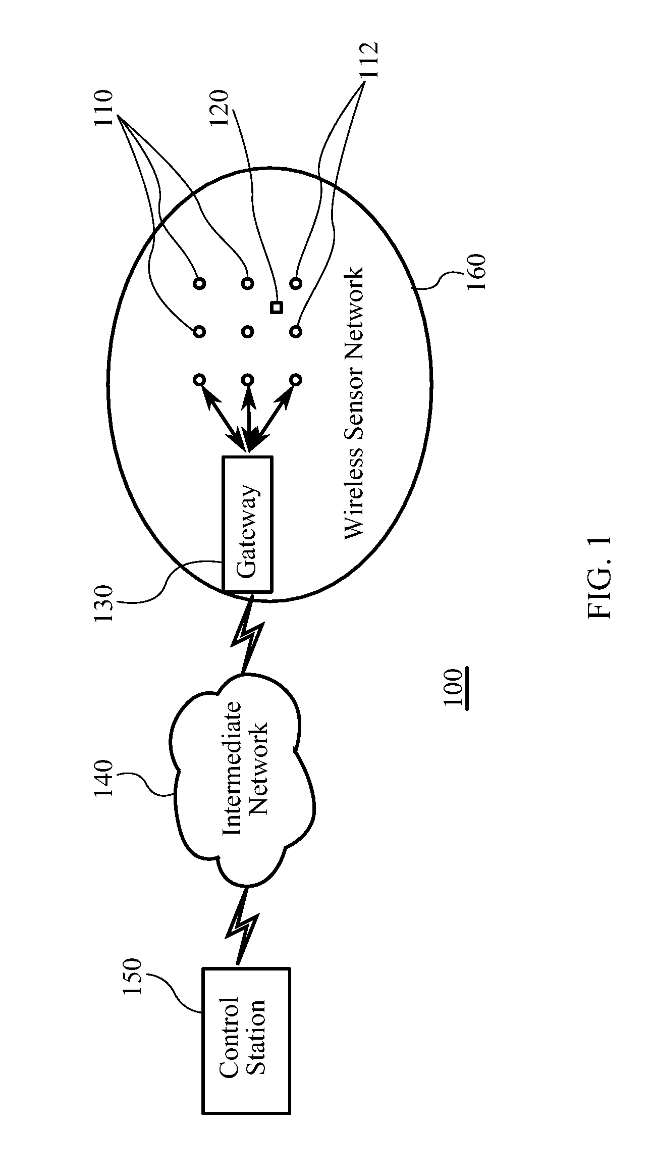
[0030]Referring to FIG. 1, a schematic view of a wireless sensing system 100 according to an embodiment of the invention is shown. Wireless sensing system 100 may advantageously permit a user to centrally operate from a base station or control station 150 (master node) to remotely access and control data collected by a wireless sensor network 160, such as by communication of such data through an intermediate network 140.

[0031]Wireless sensor network 160 includes a plurality of spatially distributed wireless sensor nodes 110 (hereinafter generally referred to as “PEGs 110”) and a sensor communication gateway 130. In a preferred embodiment of the present invention, the networking topology for implementing the wireless sensor network 160 may be a mesh network topology, in which PEGs 110 may relay sensor data collected thereby to gateway 130 either directly or in “multi-hop” fashion involving automatic routing through several other PEGs 110 within mesh network 160. The routing of data i...


PUM


Abstract

A method of self-organizing sensor nodes in a wireless sensor network (WSN); a method of localizing mobile nodes in a WSN; and a method of self-calibrating a WSN are disclosed. The method of self-organizing sensor nodes in a WSN includes configuring sensor nodes to in turn broadcast consecutive messages at a plurality of pre-defined and incrementally increasing power levels; detecting receipt of the broadcasted messages at each of the sensor nodes and notifying a master node as to the identity of each sensor node receiving the broadcasted message and the power level at which it was received to define a detected neighborhood for each sensor node; determining relative locations of sensor nodes with the detected neighborhoods; and mapping relative locations of the sensor nodes by the master node based on results of the neighborhood detection and known locations of two anchor nodes.

Description

1. TECHNICAL FIELD[0001]The present invention relates generally to the field of wireless networks, and more particularly, to the field of Wireless Sensor Networks (“WSN”).2. BACKGROUND OF THE INVENTION[0002]Wireless sensor networks may typically involve hundreds or thousands of small, preferably inexpensive sensor devices or nodes that can remotely communicate with neighboring devices such as over a wireless communication link within a limited radio range. The devices typically include a sensing ability, computational ability, and bi-directional wireless communications ability, and may also include an integrated power supply. By relaying information to each other, sensors operate to transmit signals to a command post or central network sensor or gateway which may be located anywhere within the network.[0003]Wireless sensors are used to detect any of a variety of parameters, including for example: environmental; motion or force; electromagnetic; and chemical or biological data. They ...

Claims


Application Information

Patent Timeline
Patent Type & Authority Patents(United States)
IPC IPC(8): G06F15/16G06F15/173H04B17/00H04L29/12H04W52/32H04W52/36H04W52/50H04W84/18
CPCH04L61/6081H04W84/18H04B17/0072H04W52/50H04W52/362H04W52/322H04B17/0057H04B17/27H04B17/318H04L2101/681
Inventor MARZENCKI, MARCIN JANKAMINSKA, BOZENA
Owner SIMON FRASER UNIVERSITY
Why Eureka
Try Eureka