
System and method for remote guidance of an animal to and from a target destination

a technology for remote guidance and animals, applied in the field of gps prediction methods, can solve the problems of no system melding, nor offer dynamic control of pets

Inactive Publication Date: 2015-02-17
WOLFGIS
View PDF2 Cites 40 Cited by
  • Summary
  • Abstract
  • Description
  • Claims
  • Application Information

AI Technical Summary

Benefits of technology

This patent describes a system and method for using GPS to guide dogs or other animals to a specific location. The system uses auditory cues or electrical shocks to keep the animal confined within a safe corridor and moving towards the target. The main technical effects of this invention are improved safety and efficiency in animal training and guidance, as well as increased control and accuracy in animal navigation.

Problems solved by technology

However, while the tracking of animals and especially pets is already known, especially with GPS based technology, no systems meld a moving dynamic relationship between an owner's position and their pet's position, nor offer dynamic control of a pet to effect the pet's movement from one location to another.

Method used


Image

  • System and method for remote guidance of an animal to and from a target destination
  • System and method for remote guidance of an animal to and from a target destination
  • System and method for remote guidance of an animal to and from a target destination

Examples


Embodiment Construction

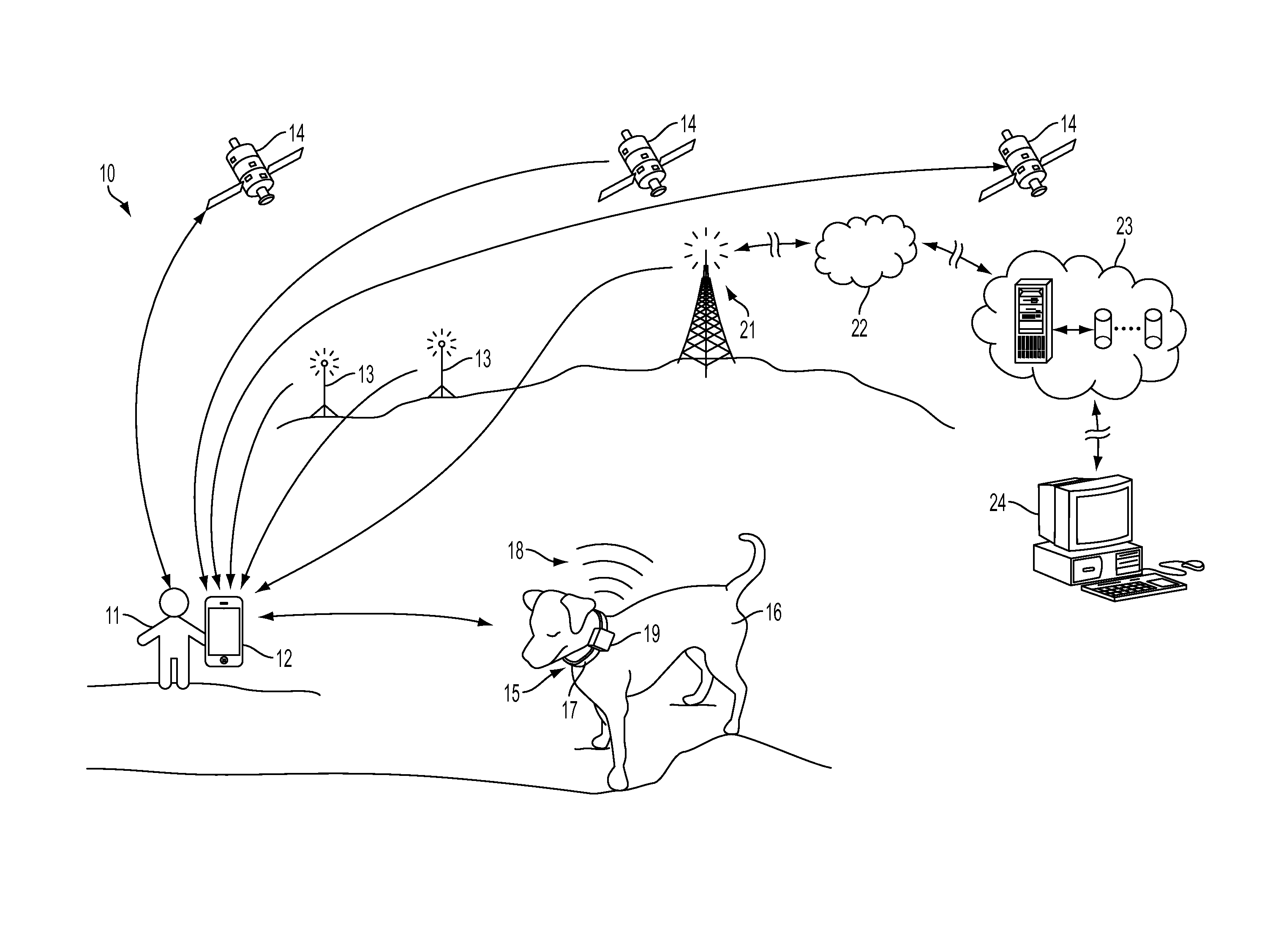
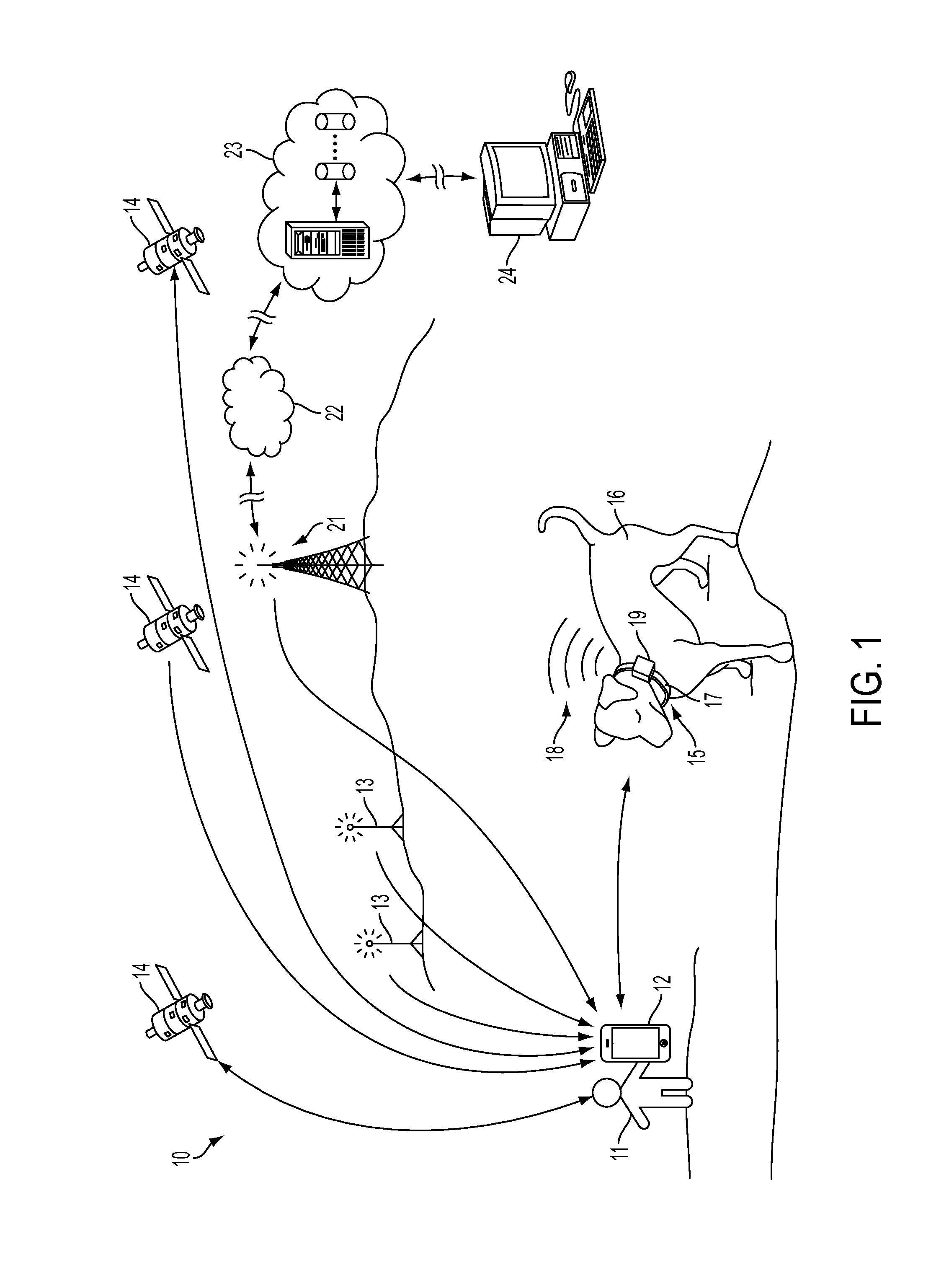
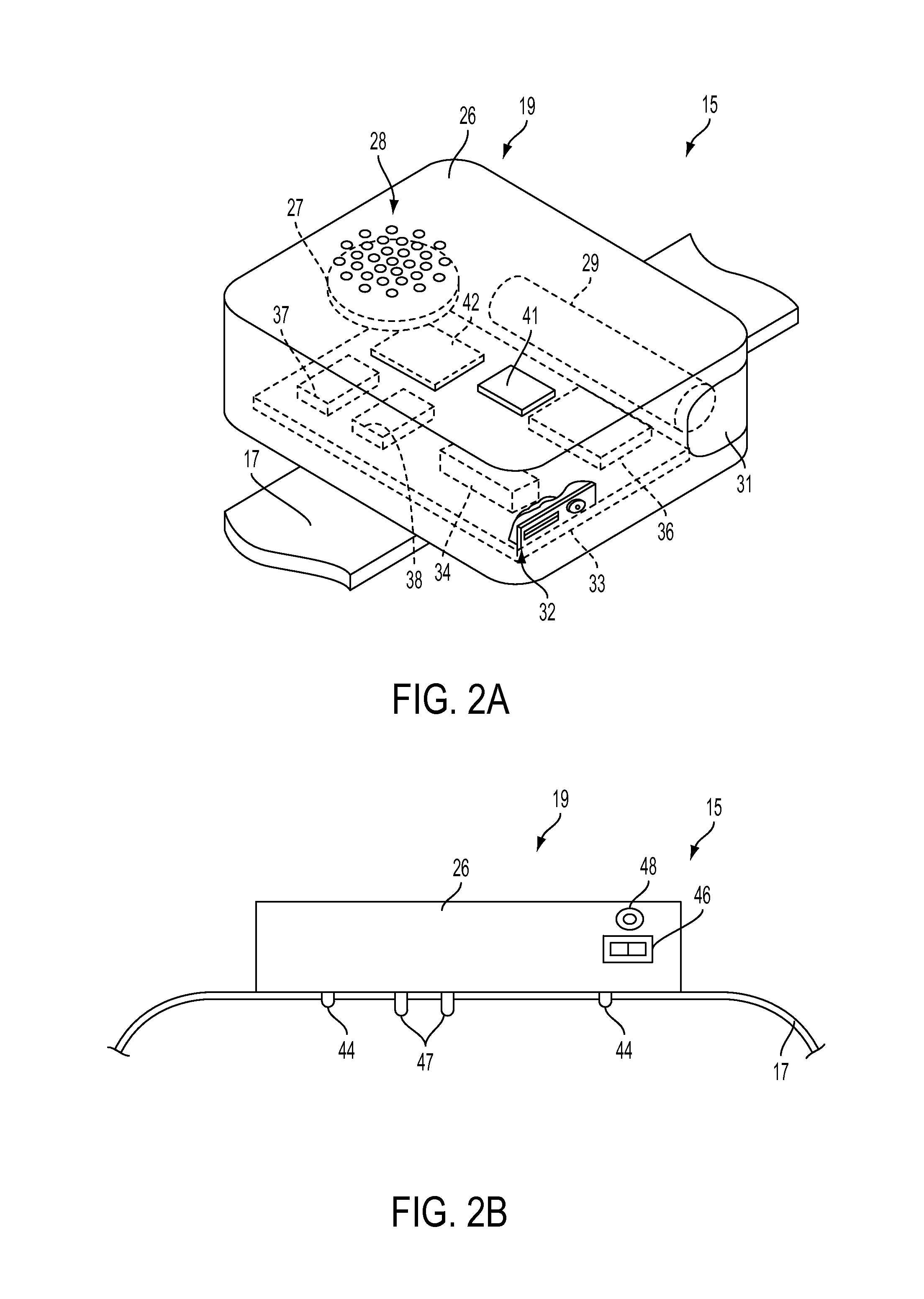
[0023]Referring to the drawings for a better understanding of the function and structure of the invention, FIG. 1 shows a schematic view of the communications infrastructure 10 utilized by the present invention during typical use. In this sample scenario, an individual 11 desires to guide the movement of a dog 16. The user initiates a software application on mobile device 12, which includes receivers capable of detecting signals originating from GPS satellites 14, WiFi repeater / booster stations 13, and one or more cell towers 21, as well as signal 18 originating from the electronics module 19 located on the dog's collar 15.

[0024]By connecting with the Internet 22 via WiFi, Bluetooth, or cell transmissions, the software application can access both land tract data and the dog's geo-positional data stored in a SQL relational database on a remote server, such as cloud server 23. The data contained on cloud server 23 can also be accessed and modified by remote computing device 24, such a...


PUM


Abstract

A system and method for remote guidance of a dog or other suitable animal to and from a selected location using GPS related triangulation methods. The system using a series of audible cues or electrical shocks to guide the dog from a current location to a target location by continually monitoring the current GPS location of the dog and establishing a waypoint target for the animal as it moves. The system issues cues such as audible signals to control the dog and keep it confined within a suitable corridor so that the next waypoint may be attained. Using the invention, a dog owner can control the movement of the dog as the owner moves in its proximity, thereby creating an invisible tether or “virtual leash” or to the animal.

Description

[0001]This application claims the benefit of filing priority under 35 U.S.C. §119 and 37 C.F.R. §1.78 of the U.S. Provisional Application Ser. No. 61 / 497,842 filed Jun. 16, 2011, for a Software Algorithm For Mobile Devices Using Position Sensor To Lock User Position Within Boundary Lines, and U.S. Provisional Application Ser. No. 61 / 551,842 filed Oct. 26, 2011, for a Dog Collar with Aural Cues and Tract-Lock GPS Technology. All information disclosed in those prior provisional applications is incorporated herein by reference.FIELD OF THE INVENTION[0002]The present invention relates generally to devices using GPS based software and hardware to determine an Earth based location. In greater particularity, the present invention relates to GPS prediction methods. In even greater particularity, the present invention relates to animal control collars to confine an animal to predefined boundary area.BACKGROUND OF THE INVENTION[0003]The use of global positioning systems (GPS) to determine the...

Claims


Application Information

Patent Timeline
Patent Type & Authority Patents(United States)
IPC IPC(8): A01K15/04H04W4/02H04W4/021H04W4/024
CPCH04L67/125H04W4/021H04W4/023H04W4/027A01B79/005G01C21/005G08B21/0261A01K15/023A01K15/021H04W4/02H04L67/55H04W4/024
Inventor GOLDEN, JOHN MICHAEL
Owner WOLFGIS
Learn More