Method for recognizing non-gauged star map

A star map recognition and non-calibration technology, applied in the field of star map recognition, can solve the problems of grid algorithm influence, grid deviation, focal length change, etc., to achieve the effect of speeding up speed and efficiency, reducing occupation, and reducing storage space

Inactive Publication Date: 2009-06-24
BEIHANG UNIV
View PDF2 Cites 0 Cited by
  • Summary
  • Abstract
  • Description
  • Claims
  • Application Information

AI Technical Summary

Problems solved by technology

However, during the operation of the star sensor, the focal length of the lens will change, and the resulting image will also be enlarged or reduced. If the calibration of these two parameters is not accurate, or the star sensor changes during the flight, then, The angular distance value calculated on this basis will have a large error, and then the search range of the navigation database must be expanded during identification, which will increase the calculation burden and identification time, and the identification accuracy will also decrease.
[0003] Similarly, the current popular raster algorithm also needs to use calibration parameters such as focal length when dividing the grid, otherwise the divided grid will deviate, and the eigenvector will change accordingly, so that it cannot be correctly identified
If the star sensor encounters a sudden situation in flight and the focal length changes, the raster algorithm will be greatly affected

Method used


Image

  • Method for recognizing non-gauged star map
  • Method for recognizing non-gauged star map
  • Method for recognizing non-gauged star map

Examples


Embodiment Construction

[0029] The present invention will be further described below in conjunction with the accompanying drawings.
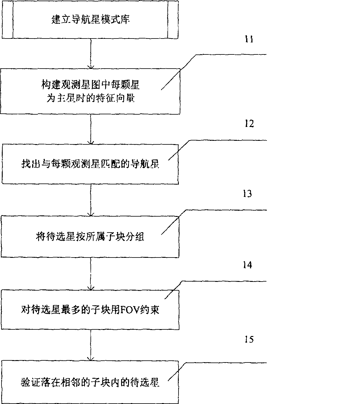
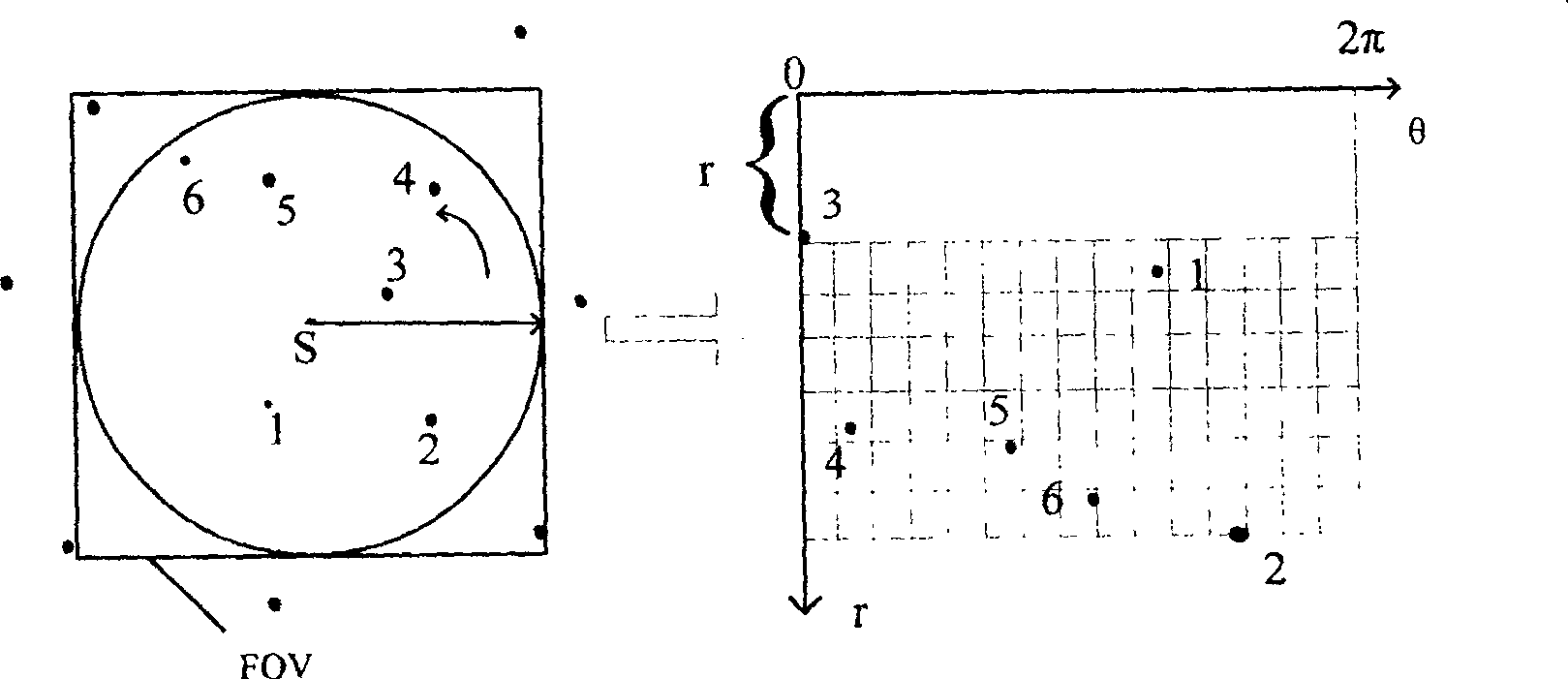
[0030] The main idea of ​​the present invention is: extract the feature vector of the navigation star, set up a navigation star pattern library based on raster data storage; extract the feature vector according to the pattern of the navigation star from the observation star map, and then use the observation star map and the navigation star pattern library According to the initial matching result of the star to be selected, the star to be selected is determined, and the star to be selected is grouped according to the uniform division method of the celestial sphere, and the direction of the field of view is determined according to the sub-block attribution of the star to be selected.

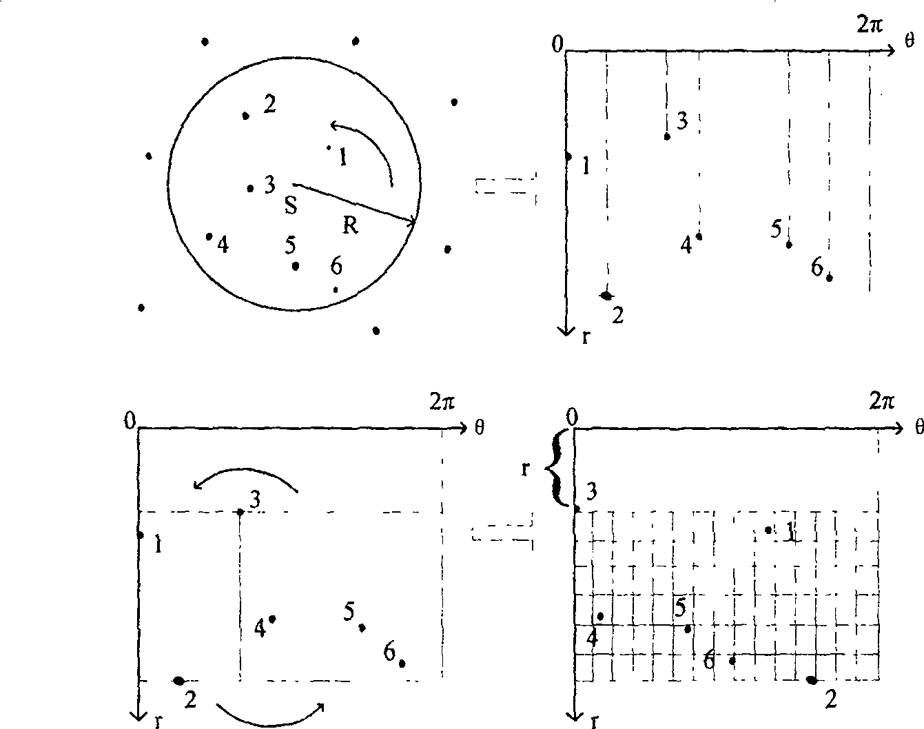
[0031] Wherein, the extraction of the feature vector of the star map mainly uses the radial feature and the circular feature.

[0032] figure 1 It is the realization flowchart of the star...


PUM


Abstract

The invention relates to a non-calibration star map recognition method, which comprises the following steps: extracting a navigation star feature vector, establishing a navigation star pattern library based on grid storage; when performing star map recognition, extracting the observation star feature vector, according to the The extracted feature vectors are matched in the navigation star pattern library to determine the stars to be selected; all the stars to be selected are grouped, and the field of view direction is determined according to the attribution of the stars to be selected. In the identification process, the invention introduces the proportional distance independent of any optical system parameters such as focal length and principal point position as the radial feature, and the angle as the circumferential feature, with small storage space, fast and accurate identification, and can provide a basis for on-orbit calibration of aircraft.

Description

technical field [0001] The invention relates to a star map recognition technology, in particular to a non-calibration star map recognition method. Background technique [0002] The star sensor is an attitude measurement component widely used in aerospace vehicles, and it is an important part of the work of the star sensor to realize the recognition of the observed star map. The so-called star map recognition is to match the star map observed by the star sensor with the navigation star map in the existing navigation star catalog to determine the corresponding relationship between the observed star and the navigation star. The existing star map recognition algorithm must rely on the imaging model of the star sensor and the parameters of the imaging system. For example, the current popular recognition algorithm based on angular distance uses the focal length of the star sensor lens and the principal point position of the image plane to calculate the angle. distance, which requ...

Claims


Application Information

Patent Timeline
Patent Type & Authority Patents(China)
IPC IPC(8): G01C21/02G01C11/04G01V8/10
Inventor 张广军杨建江洁
Owner BEIHANG UNIV
Why Eureka
Try Eureka