Mobile space data collection and processing and publishing method

A spatial data and data acquisition layer technology, applied in the field of mobile spatial information communication, can solve problems such as low work efficiency, expensive notebook configuration costs, and short battery power supply time, so as to improve work efficiency, save workload, save manpower and Material effect

Inactive Publication Date: 2007-10-10
上海市闸北区绿化管理局 +1
View PDF0 Cites 43 Cited by
  • Summary
  • Abstract
  • Description
  • Claims
  • Application Information

AI Technical Summary

Problems solved by technology

This method has made some progress in the working mode, but the configuration cost of the notebook is more expensive and the battery power supply time is short, which is a limitation to the actual use of the greening survey. The attribute data is recorded on the paper medium, and the work is also repeated when the office processing and matching are performed indoors, and the work efficiency is low

Method used


Image

  • Mobile space data collection and processing and publishing method
  • Mobile space data collection and processing and publishing method
  • Mobile space data collection and processing and publishing method

Examples


Embodiment Construction

[0044] The present invention will be further described below in conjunction with the accompanying drawings and embodiments.

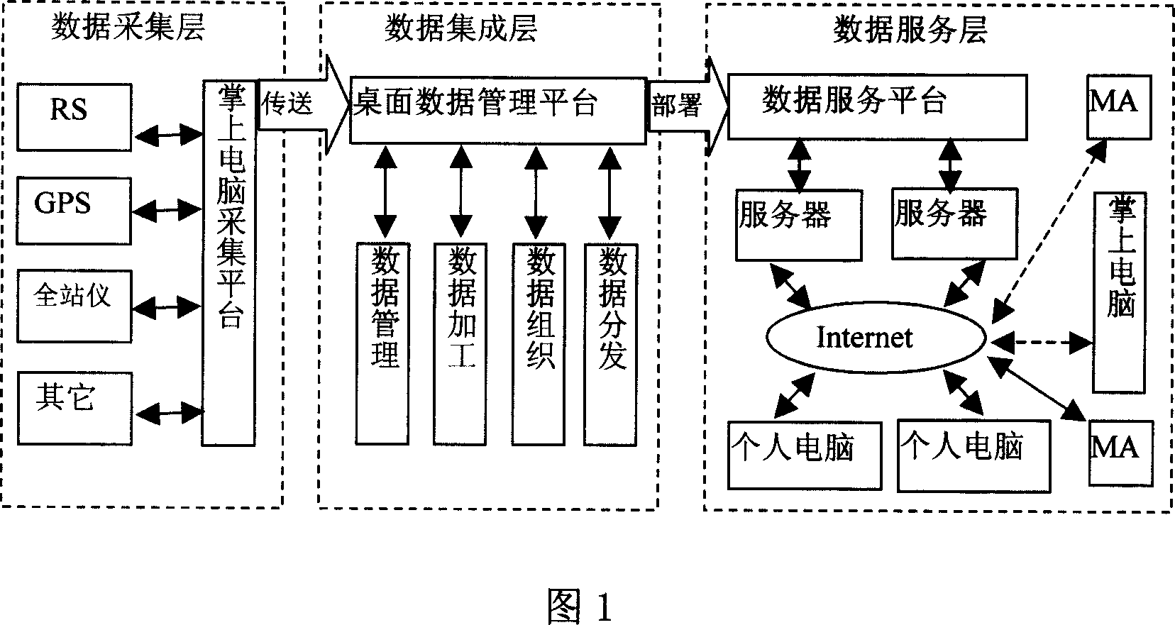
[0045] As shown in Figures 1 to 11, this embodiment adopts equipment and software such as GPS RTK, differential GPS, remote sensing, total station, mobile GIS, network communication, office data integration management GIS, WEBGIS, PDA (handheld computer), and develops Based on PDA-based GIS software, develop a platform-level office data integration and management GIS for office processing and management, build a WEBGIS system for publishing spatial information online to release data, and realize spatial information measurement, attribute investigation, and data management and release on the Internet. One, generally divided into data acquisition layer, data integration layer and data service layer, as shown in Figure 1.

[0046] GPS coordinate conversion:

[0047]In the application of GPS positioning measurement, since the GPS positioning results are ba...


PUM


Abstract

A method for processing mobile space data includes utilizing windows operation system and development environment provided by said system, embedded windows CE operation system and embedded development environment being provide by window CE operation system and being set with data collection layer and data integrated layer as well as data service layer to process mobile space data; sending data collected by data collection layer to data integrated layer for making treatment on data there and transmitting treated result to data service layer through radio transmission for issuing result there.

Description

technical field [0001] The invention relates to the field of mobile space information communication, in particular to a method for collecting, processing and publishing mobile space data. Background technique [0002] GPS (Global Positioning System)-Global Positioning System, mainly realizes the positioning of the mobile terminal through multiple satellites. The mobile terminal receives the GPS information and processes it by itself or the network service center to determine the actual location of the mobile terminal. Since former U.S. President Clinton promulgated a decree to stop the S / A policy on May 1, 2000, the civilian code will not be interfered, which greatly improves the accuracy of civilian positioning. At the same time, this also accelerates and expands the application of GPS in all walks of life. With the wide application and development of GPS technology, many different types of GPS receivers have emerged. Currently, there are two main types of GPS receivers: ...

Claims


Application Information

Patent Timeline
Patent Type & Authority Applications(China)
IPC IPC(8): G01S5/02G01S1/02G01S19/46
Inventor 童小华胡广杰田根唐德昌蔡杰
Owner 上海市闸北区绿化管理局
Why Eureka
Try Eureka