Integration of navigation and communication based on time location and status information

A state information, time and position technology, applied in the space field, can solve problems such as loss, failure to inform the emergency center, delay in emergency time, etc., and achieve the effect of high navigation accuracy

Inactive Publication Date: 2007-12-05
NAT ASTRONOMICAL OBSERVATORIES CHINESE ACAD OF SCI
View PDF2 Cites 34 Cited by
  • Summary
  • Abstract
  • Description
  • Claims
  • Application Information

AI Technical Summary

Problems solved by technology

In actual situations, the vast majority of 911 callers are often unable to inform the emergency center of their exact location d...

Method used


Image

  • Integration of navigation and communication based on time location and status information

Examples


Embodiment Construction

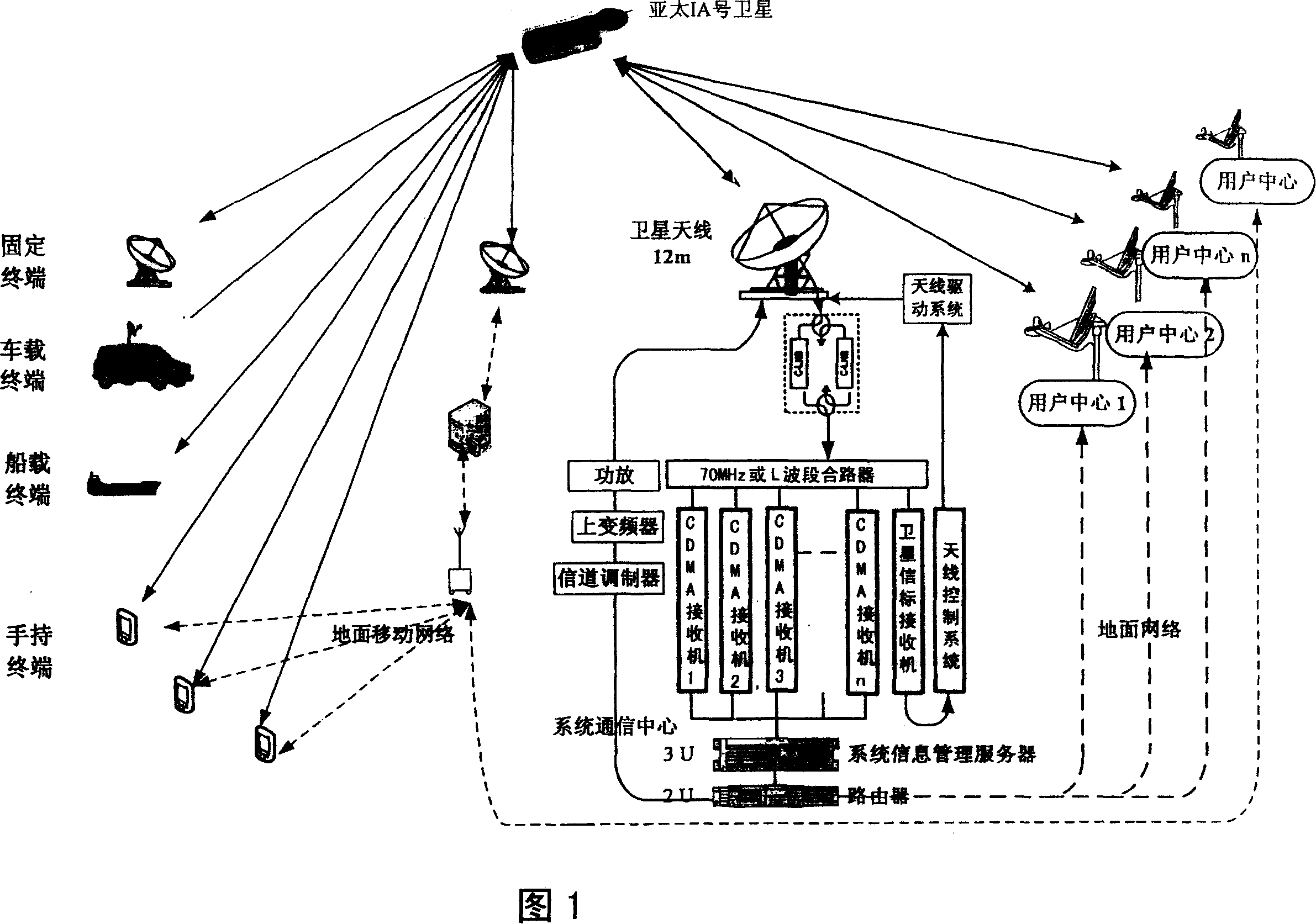
[0023] Logistics vehicle management, battlefield assessment, impact point report, combat command, individual broadcast information, etc. belong to this type of system. The system is divided into a terminal backhaul system (called "incoming" or "incoming" link), and a broadcast communication link (called "outgoing" or "outgoing" link). The system structure is shown in Figure 1.

[0024] From the perspective of equipment composition, the system consists of space segment, communication center, user center and user terminal.

[0025] Space segment resources: Various types of communication satellites are used, but the use of decommissioned satellites (patent application number: 200610055909.2) greatly reduces the cost of system construction and operation. A low-rate data communication network is established by using the remaining transponders of CAPS decommissioned communication satellites as space segment resources.

[0026] Communication Center: An antenna with a caliber of 10-1...


PUM


Abstract

The invention relates to the space orientation and the communication domain, which based on guidance correspondence integration system of the time position and status messages. The system use central station with the heavy-caliber antenna as relaying, can support the information feedback service about the guidance terminal, and can also support the broadcast service about the tie-station. Even in the region communication network can not cover in the ground, using the own satellite resources of repeater type satellite navigational system, can complete guidance and correspondence function, can orient any user's position in any place of the world precisely, which is effective supplement of the the repeater type satellite navigational system, especially suit for oceangoing voyage, and battle, research, exploration in the unpopulated area.

Description

technical field [0001] The invention relates to the field of space technology, and is a system design for realizing communication functions by utilizing the resources of the navigation system itself, in particular, a navigation and communication integrated system based on time, position and status information. Background technique [0002] The current satellite navigation system only has the functions of navigation, positioning, and timing. In fact, navigation users need to transmit information while positioning, and also need to obtain some required information. However, these requirements cannot be realized by the system itself, such as reporting to the center. Business requirements such as the location of the user, the order issued by the receiving center to the user, etc. The traditional method is to combine the navigation and positioning system with other communication systems to complete the above functions, such as the combination of the satellite positioning system (...

Claims


Application Information

Patent Timeline
IPC IPC(8): H04B7/185G01C21/00G01S1/02G01S19/01G01S19/39
Inventor 尚俊娜施浒立卢晓春周晓
Owner NAT ASTRONOMICAL OBSERVATORIES CHINESE ACAD OF SCI
Why Eureka
Try Eureka