Low-cost combination type positioning and orienting device and combined positioning method
A positioning, directional, combined technology, applied in the directions of measuring devices, instruments, surveying and navigation, etc., can solve the problems of GPS positioning failure and GPS signal occlusion, and achieve the effect of improving measurement accuracy, low accuracy and rich interfaces.
Inactive Publication Date: 2010-09-08
HARBIN ENG UNIV
View PDF0 Cites 2 Cited by
- Summary
- Abstract
- Description
- Claims
- Application Information
AI Technical Summary
Problems solved by technology
However, the problem with the GPS system is that when in use, the tall trees or high-rise buildings in the city have a blocking effect on the GPS signal, that is, the urban Grand Canyon effect, which will cause the GPS positioning to fail.
However, the electronic compass is greatly affected by the magnetic medium of the external environment. If the compensation is not proper, the heading measurement error can reach tens of degrees.
Method used
View moreImage
Smart ImageViewing Examples
Examples
Embodiment Construction
Login to View More PUM
 Abstract
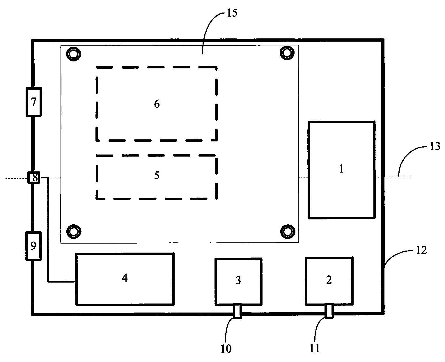
The invention provides a combined locating and orienting device with lower cost and a combined locating and orienting method thereof. The device mainly includes an MEMS INS consisting of an MEMS IMU and a navigation computer, a GPS receiver, a 3D digital electric compass, an altometer, an aerodromometer, a power module, a box body, a socket connector, etc; wherein, the MEMS INS includes 9 MEMS gyroscopes and 6 double-axis MEMS accelerometers which respectively measure the palstance and the acceleration of a moving carrier; then the palstance and the acceleration are inputted into a navigationcalculating program to calculate the information like the pose, the position and the speed of an obtained carrier. Simultaneously, the navigation computer regularly collects the information of the navigation sub-units like the GPS receiver, the 3D digital electric compass, the aerodromometer and the altometer by a 232 series port and obtains the best navigation information like the position, the pose, the speed and the height of the carrier by information fusion processing; the precision of the invention is better than a single sub-system in the device. The combined locating and orienting device with lower cost has the advantages of small size, low power consumption, low cost, complete functions and abundant interfaces, thus being capable of completely meeting the locating and orienting requirements with middle precision for carrying the carrier on the ground or in the air.
Description
(1) Technical field The present invention relates to a positioning and orientation device, in particular to a micro-combined positioning system composed of a micro-inertial navigation system (MEMSINS), a global positioning system (GPS), an electronic compass, a miniature pressure altimeter and a miniature pressure airspeed gauge, etc. Orientation device. The invention also relates to a positioning and orientation method using the low-cost combined positioning and orientation device. (2) Background technology The basic principle of inertial navigation is based on Newton's laws of mechanics, by measuring the acceleration and angular velocity of the carrier in the inertial reference system, integrating it with time, and transforming it into the navigation coordinate system, the speed in the navigation coordinate system can be obtained , position and attitude angle information, etc. Therefore, it is an autonomous navigation system that does not depend on any external informati...
Claims
Login to View More Application Information
Patent Timeline
 Patent Type & Authority Patents(China)
IPC IPC(8): G01C21/00G01C21/18
Inventor 何昆鹏高延滨张勤拓肖吕怡胡文彬许德新郝颖任蕾
Owner HARBIN ENG UNIV
Features
- R&D
- Intellectual Property
- Life Sciences
- Materials
- Tech Scout
- Unparalleled Data Quality
- Higher Quality Content
- 60% Fewer Hallucinations
Learn More Browse by: Latest US Patents, China's latest patents, Technical Efficacy Thesaurus, Application Domain, Technology Topic, Popular Technical Reports.
© 2025 PatSnap. All rights reserved.Legal|Privacy policy|Modern Slavery Act Transparency Statement|Sitemap|About US| Contact US: help@patsnap.com


