Data acquisition system and method based on GPS and website map server

A technology of data collection system and site map, applied in transmission system, radio wave measurement system, satellite radio beacon positioning system, etc., can solve problems such as lack and error, and achieve the effect of convenient and intuitive browsing

Inactive Publication Date: 2009-02-18
WUHAN ZHONGYI GEOPHYSICAL TECH
View PDF0 Cites 9 Cited by
  • Summary
  • Abstract
  • Description
  • Claims
  • Application Information

AI Technical Summary

Problems solved by technology

Due to the lack of support for operation process monitoring means and data identification technolo

Method used


Image

  • Data acquisition system and method based on GPS and website map server
  • Data acquisition system and method based on GPS and website map server
  • Data acquisition system and method based on GPS and website map server

Examples


Embodiment Construction

[0030] Various embodiments of the present invention will be described below with reference to the accompanying drawings.

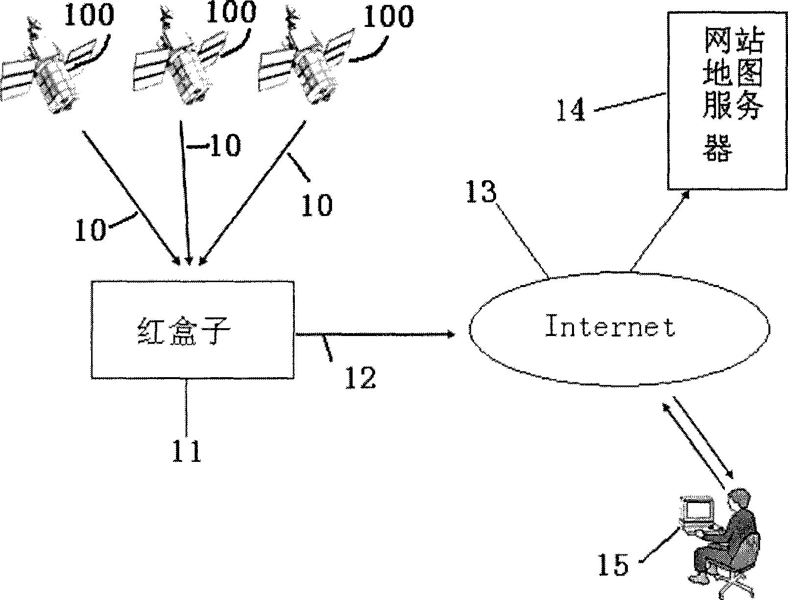
[0031] refer to figure 1, shows the monitoring and data collection system based on GPS technology and site map server of the present invention. The monitoring and data collection system of the present invention comprises to red box 11, communication link 12, website map server 14, terminal equipment 15, a plurality of global positioning system (GPS) satellites 100, each satellite all outputs GPS signal 10, red box After receiving the GPS signal, combined with the detection data or detection data encoding, the combined data is packaged and sent to the site map server 14 through the wireless communication link 12 and the Internet network 13, and the user uses the terminal device 15 to access the site map through the Internet network 13 The server obtains job information and probe data or codes of probe data.

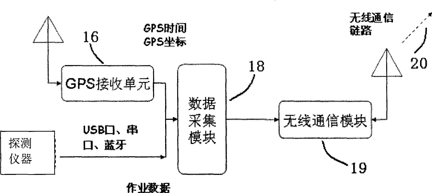
[0032] refer to figure 2 , shows the composi...


PUM


Abstract

The invention relates to a data-collecting system and a method thereof based on a GPS and a network map server, the system comprises: a red box equipment, a network map server and a terminal equipment. The red box equipment is connected in the Internet through a wireless communication link and connected with the network map server, and the terminal equipment is connected with the network map server via Internet; through the red box carried by constructors in situ, the method can receive GPS signals from a GPS satellite and determine the position message of the constructors, combined data can be formed by combining the collected detecting data or detecting data code and the information of time and position, and can be sent to the network map server through the wireless communication link; the network map server supplies electric map services which include satellite images and geographical labels, working trace monitoring and replaying, and the data labeling interface, the users can connect to the Internet through the terminal equipment, so as to dynamically monitor the operation trace in real time, browse data labels with different visual characteristics on the electric map, and intuitively browse, manage and query data with much convenience.

Description

technical field [0001] The invention relates to a system for providing data collection based on GPS and a site map server for engineering construction personnel and managers. The projects involved in the present invention include but are not limited to underground pipeline detection, drainage pipeline detection, water supply pipeline leak detection, gas leakage detection, pile foundation detection, and geological exploration. Background technique [0002] The construction of most projects is characterized by large-scale multi-point mobile operations, which require multiple labor and equipment to carry out construction at the same time. Due to the corresponding relationship between job data and geographic coordinate points, the traditional manual recording method is extremely prone to misalignment of data and geographic coordinate points. For example, the depth and current data obtained by pipeline detection have a corresponding relationship with the detection points. When c...

Claims


Application Information

Patent Timeline
IPC IPC(8): G01S5/02H04L29/08G01S19/01
Inventor 王永涛方波冯成会
Owner WUHAN ZHONGYI GEOPHYSICAL TECH
Why Eureka
Try Eureka