Star-loaded SAR image geocoding method based on star ground coordinate transformation

A technology of geocoding and coordinate conversion, applied in the field of image processing, can solve the problems of influence of processing accuracy, low processing efficiency, and difficulty in realizing high-precision geocoding of spaceborne SAR images.

Inactive Publication Date: 2009-04-22
BEIHANG UNIV
View PDF0 Cites 19 Cited by
  • Summary
  • Abstract
  • Description
  • Claims
  • Application Information

AI Technical Summary

Problems solved by technology

[0007] Just because the R-D positioning model requires iterative calculations and the processing efficiency is low, the processing model is often modified in practical applications, and various approximations are made to the model without affecting the application, and then the display solution under certain conditions is obtained. Although the method improves the processing efficiency, the processing accuracy is greatly affected, and it is difficult to achieve high-precision geocoding of spaceborne SAR images

Method used


Image

  • Star-loaded SAR image geocoding method based on star ground coordinate transformation
  • Star-loaded SAR image geocoding method based on star ground coordinate transformation
  • Star-loaded SAR image geocoding method based on star ground coordinate transformation

Examples


Embodiment Construction

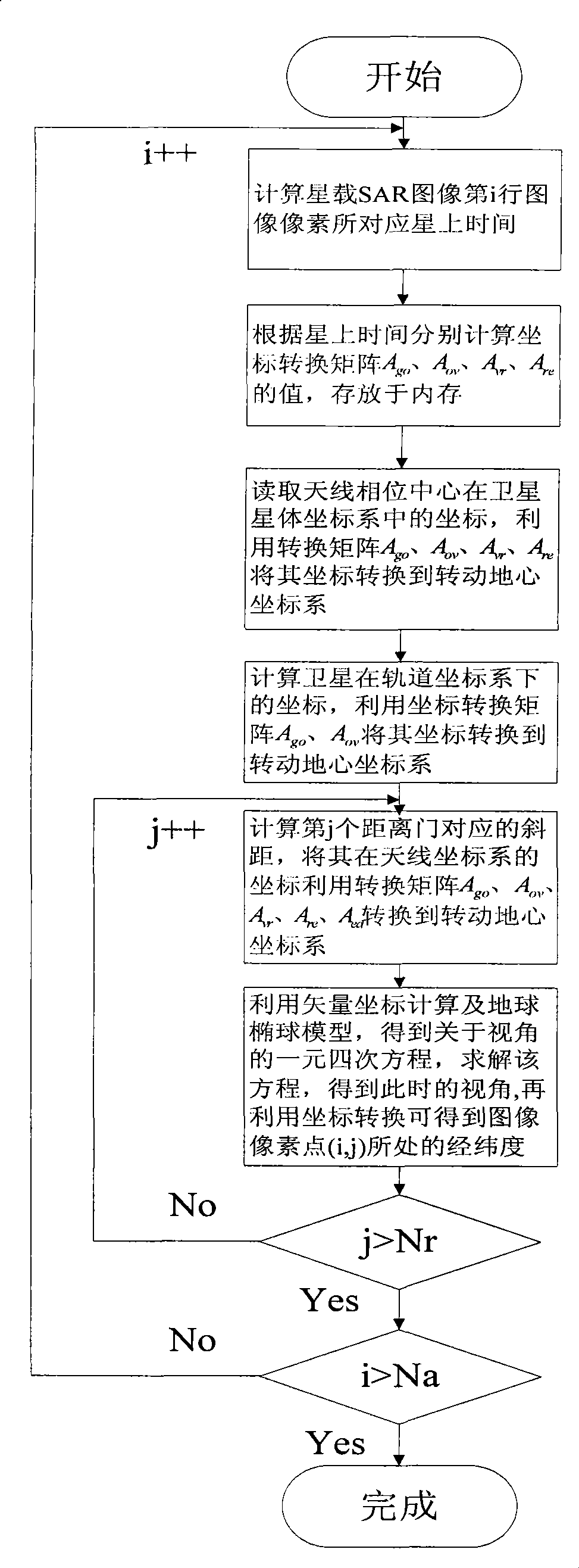
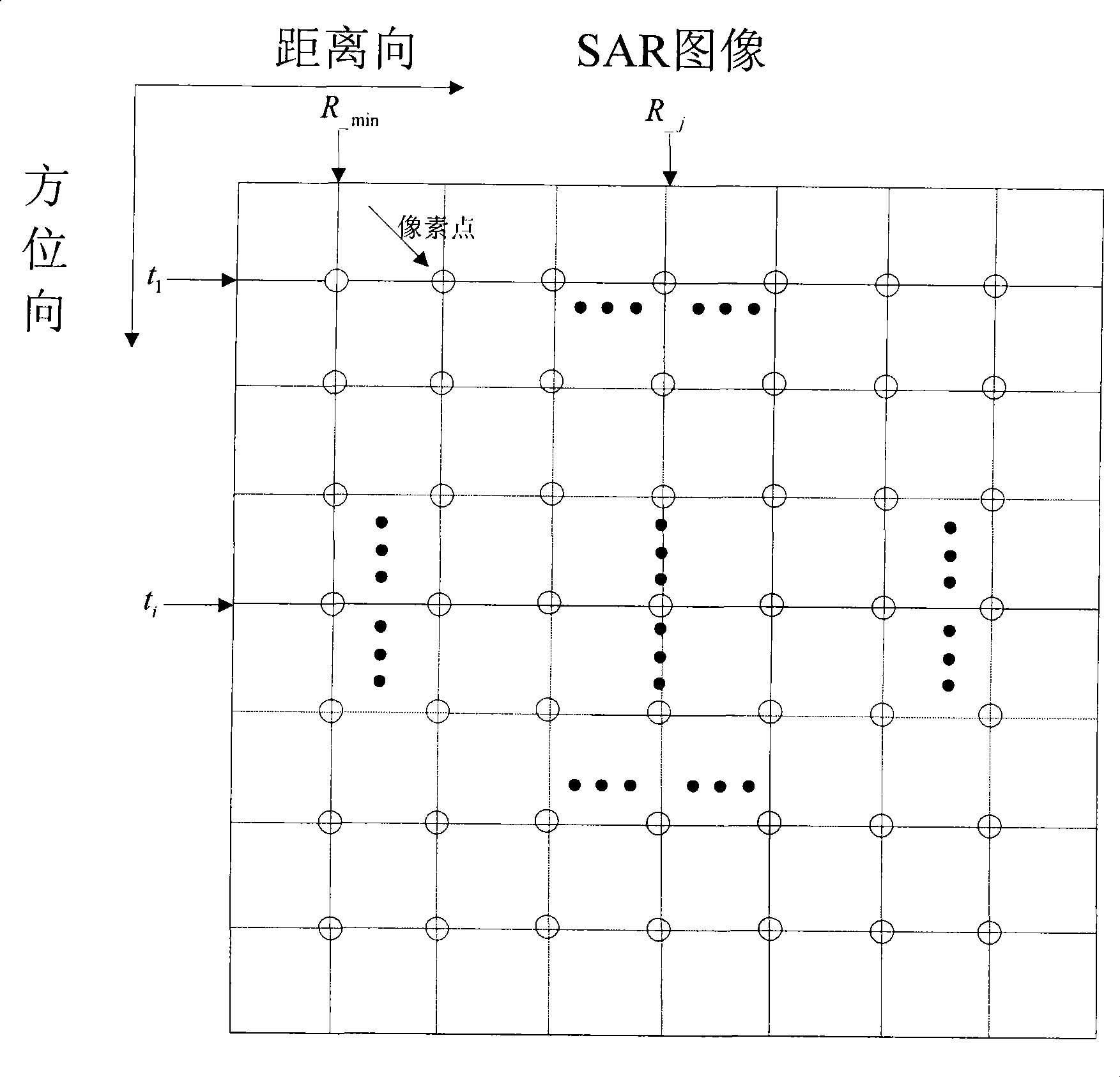
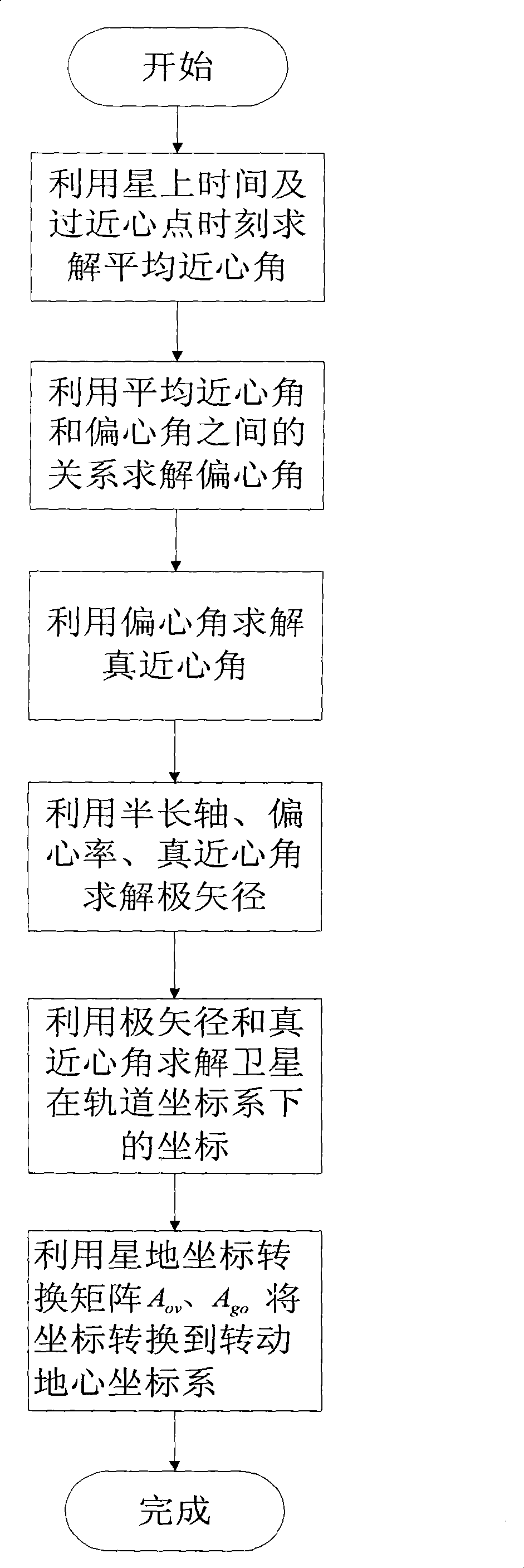
[0133] See figure 1 , figure 2 , image 3 , Figure 4 , Figure 5 , Image 6 , Figure 7 as shown,

[0134] The present invention is based on a space-borne SAR image geocoding method based on satellite-ground coordinate conversion. Taking a SAR image with a size of 2048x2048 as an example, the specific steps of the method are as follows:

[0135] Step 1: Read in satellite ephemeris parameters, including: eccentricity e=0.003, semi-major axis a=7071140.0m, ascending node equator Ω=69.517572°, perigee depression angle ω=0.0°, orbital inclination i=99.038314°, wave Front slope distance R _min =787796.306m, signal sampling rate f s =75.0MHz, pulse repetition frequency prf=2300.0Hz, time of perigee τ=-9.6465s, speed of light c=3.0e8m / s, Greenwich time angle H G = 0.0s.

[0136] The implementation condition of this step is that by-products of SAR image-related information need to be provided, and satellite ephemeris parameters will be included in the by-products. Currentl...


PUM


Abstract

The invention provides a geocoding method for spaceborne SAR images based on conversion of satellite topocentric coordinates. A relation of six coordinate systems among the satellite topocentric coordinates is used, and an observation visual angle (an intermediate variable) is skillfully used for finishing the high-precision rapid geocoding of the spaceborne SAR images on the premise of needing no iterative operation. Most of the traditional geocoding methods for the spaceborne SAR images need iterative operation, have low processing efficiency, affected positioning precision due to approximation processing in the operation, in particular has satellite velocity error which is the greatest factor affecting the precision of the traditional geocoding results of the spaceborne SAR images. The method of the invention is not affected by the satellite velocity error, when the ephemeris parameters are not very good, the positioning precision of the method is rather better than that of the traditional positioning method, thus the method is more applicable to the actual engineering application. The method is a brand-new positioning method of the spaceborne SAR images, and has great significance in realizing the rapid and high-precision geocoding of the spaceborne SAR images.

Description

technical field [0001] The invention relates to an image geocoding method, in particular to a spaceborne SAR image geocoding method based on satellite-earth coordinate conversion. It belongs to the technical field of image processing. Background technique [0002] Synthetic Aperture Radar (SAR) satellites have developed rapidly in recent years. Since SAR satellites are not limited by factors such as weather, geography, and time, they can observe the earth all day long and have certain penetrating power, so they are widely used. It is used in military reconnaissance, resource detection, ocean observation, ecological monitoring, rapid rescue, etc. [0003] With the continuous increase of application requirements, the level of spaceborne SAR image products is also continuously improved, among which the geocoding of spaceborne SAR image products is an important content of spaceborne SAR image processing, which has a wide range of application prospects, such as: rapid rescue , ...

Claims


Application Information

Patent Timeline
Patent Type & Authority Applications(China)
IPC IPC(8): G01S7/295G01S13/90
Inventor 陈杰王鹏波杨威李春升周荫清
Owner BEIHANG UNIV
Why Eureka
Try Eureka