Real time acquiring method for sea fog thickness and height of low cloud base

A technology for real-time acquisition of cloud base height, applied in height/level measurement, radio wave reflection/re-radiation, utilization of re-radiation, etc. and other issues, to achieve the effect of strong implementation and high reliability

Inactive Publication Date: 2009-04-29
OCEAN UNIV OF CHINA
View PDF0 Cites 11 Cited by
  • Summary
  • Abstract
  • Description
  • Claims
  • Application Information

AI Technical Summary

Problems solved by technology

[0002] When there is sea fog, the horizontal visibility is less than 1000 meters, which seriously affects the operations of marine transportation, seaports and coastal airports
However, there is no real-

Method used


Image

  • Real time acquiring method for sea fog thickness and height of low cloud base
  • Real time acquiring method for sea fog thickness and height of low cloud base
  • Real time acquiring method for sea fog thickness and height of low cloud base

Examples


Embodiment Construction

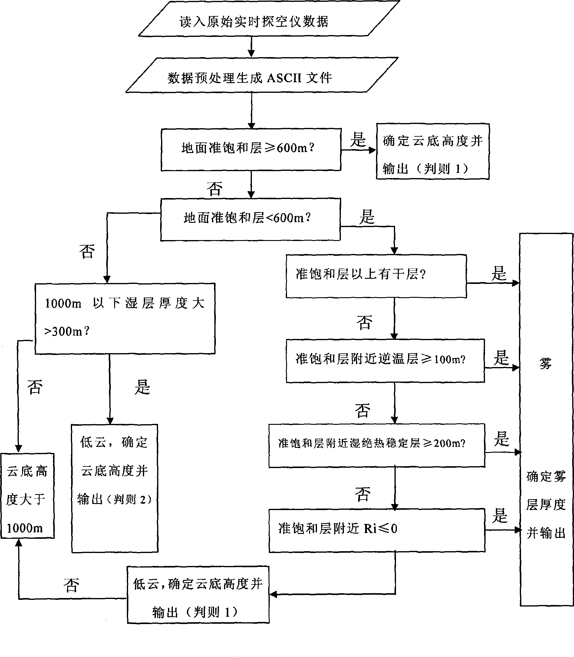
[0024] Such as figure 1 , the sea fog thickness of the present invention and the acquisition method of low cloud base height or steps are as follows:

[0025] 1. Data preprocessing. Read in the real-time data of the digital radiosonde, decode and generate an ASCII code radiosonde data file at that time, which contains the height z, temperature t, relative humidity RH, and dew point temperature t at intervals of 30m from the ground to the upper troposphere d , air pressure P, wind direction ddd, wind speed ff. Then, from the generated sounding data file, read the above data of each height layer below 1000m, and decompose the wind direction ddd and wind speed ff into meridional wind component v and zonal wind component u by conventional methods.

[0026] 2. Determine whether there is a quasi-saturated layer and the thickness of the quasi-saturated layer from the ground to the height of 1000m. According to the quasi-saturated layer criterion: RH≥93%, or temperature dew point d...


PUM

PropertyMeasurementUnit
Thicknessaaaaaaaaaa

Abstract

The invention relates to a real-time acquiring method for sea fog thickness and cloud base height of low clouds. The method fully utilizes data from L wave band secondary wind-detecting radar and digital dropsonde data of an observatory, orderly analyzes distribution characteristics of the temperature and moisture of sea fog and the low clouds in the vertical direction, calculates stability degree conditions and turbulent flow conditions of lower atmosphere when the sea fog and the low clouds exist, makes statistical analysis and concludes the conditions to separate the sea fog and the low clouds, calculates the sea fog thickness and the low clouds height, and acquires the sea fog thickness and the low clouds height. The formed computer software automatically displays the result. The invention provides an effective method for monitoring in real time, namely simultaneously establishing an objective and feasible method for automatically extracting the cloud base height of the low clouds and monitoring the sea fog thickness in real time, has strong implementation, high reliability, and provides effective meteorological data for flight safety above the sea surface, maritime traffic transportation, as well as operations on harbors and costal airports.

Description

technical field [0001] The invention belongs to marine environment monitoring technology, in particular to a method for real-time acquisition of sea fog thickness and low cloud base height. Background technique [0002] When there is sea fog, the horizontal visibility is less than 1,000 meters, seriously affecting maritime transportation, seaports and coastal airport operations. Studies have shown that the thicker the vertical thickness of the sea fog, the thicker the fog, the worse the visibility, and the harder it is to dissipate. Therefore, sea fog thickness is an important content of sea fog monitoring. However, there is no effective method for real-time monitoring of sea fog thickness. [0003] In addition, over the sea at mid-latitudes, low clouds often appear. Because the height of the cloud base of low clouds (height from the sea surface) is generally several hundred meters, it is very difficult for the aircraft to take off and land. Therefore, it is necessary to...

Claims


Application Information

Patent Timeline
IPC IPC(8): G01S13/95G01B21/08G01C5/00
CPCY02A90/10
Inventor 张苏平刘诗军刘应辰刘敬武任兆鹏杨育强王新功
Owner OCEAN UNIV OF CHINA
Why Eureka
Try Eureka