Multi-element information fusion and wireless transmission system based on GIS platform

A multi-information and wireless transmission technology, applied in the field of information systems, can solve problems such as multi-information collection and processing of target graphic elements not involved in electronic maps, etc.

Active Publication Date: 2009-06-10
YANGZHOU WANFANG ELECTRONICS TECH
View PDF0 Cites 21 Cited by
  • Summary
  • Abstract
  • Description
  • Claims
  • Application Information

AI Technical Summary

Problems solved by technology

[0002] In recent years, geographic information system (GIS) has developed rapidly. It is a technical system that uses computers as a means to manage (storage, retrieve, query, display, and analyze)...

Method used


Image

  • Multi-element information fusion and wireless transmission system based on GIS platform

Examples


Embodiment Construction

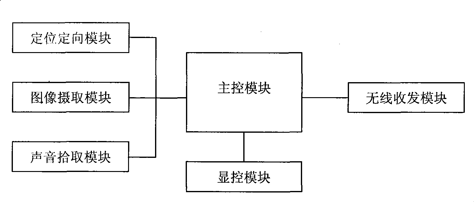
[0013] Further illustrate the present invention in conjunction with accompanying drawing and embodiment, as figure 1 As shown, the present invention is composed of a main control module, a display and control module, a positioning and orientation module, an image capture module, a sound pickup module and a wireless transmission module, and constitutes a fusion of multiple information of a target graphic element based on a GIS platform, including target position, direction, Relevant information such as identification, category, shape, voice, picture, image, etc.; for each target graphic element after information fusion, a regional situation map is formed in units of regions, accessed in the form of files, and transmitted to the information center by wireless technology. , enabling remote transmission.

[0014] The main control module adopts high-speed processor PXA270, memory RAM, flash memory FLASH to form the smallest system, expands USB host interface, 100M Ethernet interfac...


PUM


Abstract

The invention relates to a multi-information fusion and wireless transmission system based on a GIS platform, which belongs to the technical field of information system, wherein position information of a target is acquired by a GPS or an external big dipper system; the included angle of the target and the due north direction is indicated by an electronic compass; the target is subjected to image pickup by a high-resolution camera; sound information generated by the target is acquired by a sound pick-up; various messages of the acquired target are subjected to fusion processing; an electronic map is edited; proper graphic symbols are marked on the electronic map which is updated in real time; as for various target primitives after fusion processing, a regional situation map is formed by taking regions as a unit; in order to reduce the data quantity, the regional situation map is drawn by an independent map layer and stored in a file format; and the generating time of the situation map is taken as a filename, and the file is transmitted to an information center by wireless technology. The multi-information fusion and wireless transmission system based on the GIS platform can realize teletransmission through a relay, and is suitable to be used in situations such as wild mining, anti-terrorism, patrol, monitoring and reconnaissance.

Description

technical field [0001] The invention relates to a multi-information fusion and wireless transmission system based on a GIS platform, which transmits a regional situation map formed through wireless technology, and belongs to the technical field of information systems. Background technique [0002] In recent years, geographic information system (GIS) has developed rapidly. It is a technical system that uses computers as a means to manage (storage, retrieve, query, display, and analyze) various spatial data and attributes in the real world. None of the existing GIS platforms involves the collection and processing of multivariate information on the target primitives on the electronic map. Contents of the invention [0003] The purpose of the present invention is to provide a multi-element information fusion and wireless transmission system based on the GIS platform. For the existing GIS platform does not involve the collection and processing of the multi-element information o...

Claims


Application Information

Patent Timeline
IPC IPC(8): H04W4/00G01C17/32G06F17/30
Inventor 周平钱灿军孙小跃
Owner YANGZHOU WANFANG ELECTRONICS TECH
Why Eureka
Try Eureka