Method for detecting, distinguishing and locating infrared imagery sea-surface target

An infrared image, recognition and positioning technology, applied in the direction of character and pattern recognition, integrated navigator, instrument, etc., can solve the problems of not considering the recognition and positioning of target interest points, the feature quantity is not comprehensive enough, and the robustness of the segmentation method is not strong, etc.

Inactive Publication Date: 2011-04-20
HUAZHONG UNIV OF SCI & TECH
View PDF0 Cites 1 Cited by
  • Summary
  • Abstract
  • Description
  • Claims
  • Application Information

AI Technical Summary

Problems solved by technology

The segmentation method used in this method is not robust and is not suitable for complex images. The feature quantities considered in the target recognition process are not comprehensive enough, and it is difficult to adapt to target detection in complex sea environments with interference from ships, islands and reefs. The overall process does not consider the identification and positioning of target POIs

Method used


Image

  • Method for detecting, distinguishing and locating infrared imagery sea-surface target
  • Method for detecting, distinguishing and locating infrared imagery sea-surface target
  • Method for detecting, distinguishing and locating infrared imagery sea-surface target

Examples


Embodiment Construction

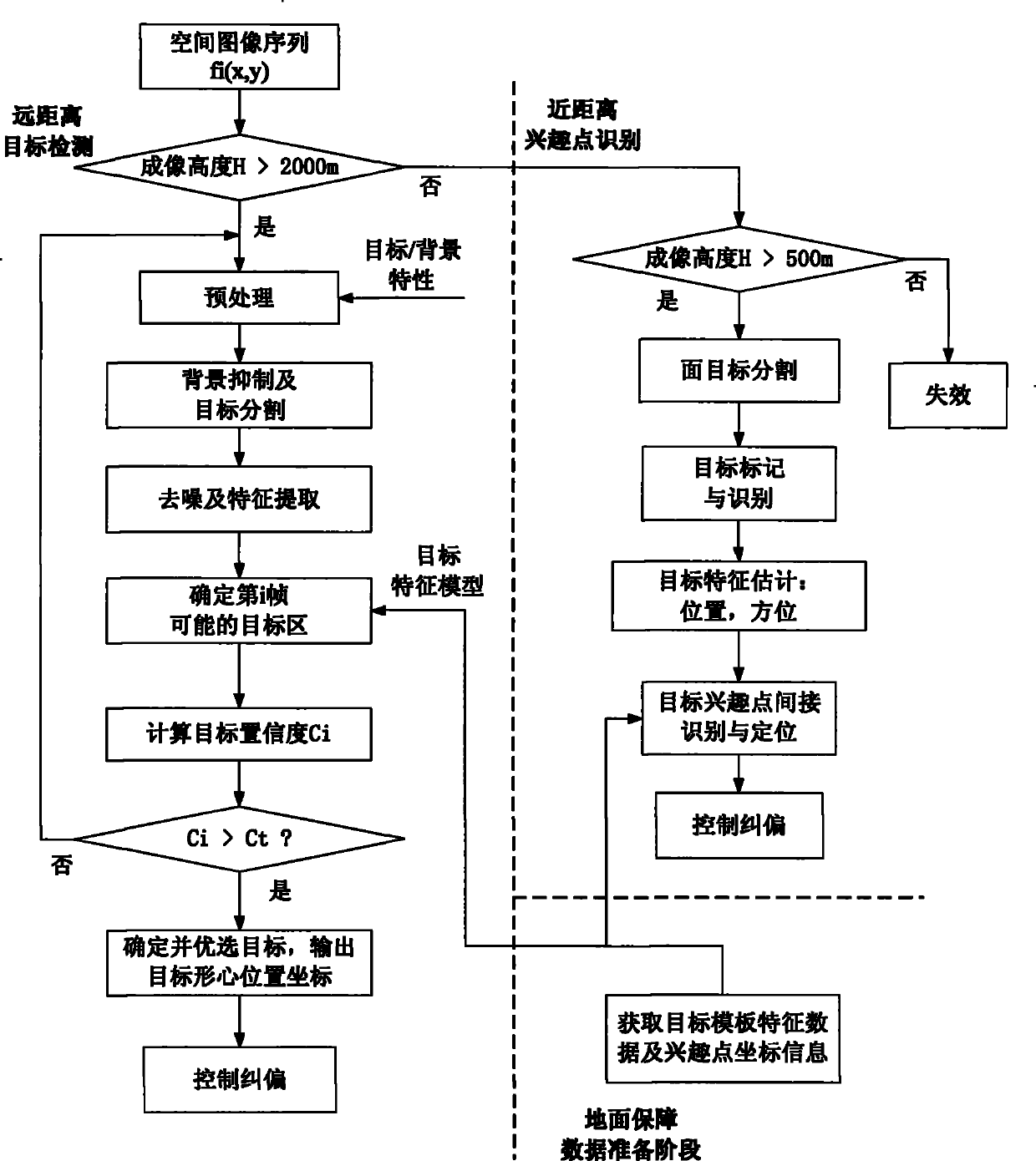
[0033] The present invention detects, recognizes and locates the target object on the infrared sea surface at a distance, and the specific processing flow is as follows: figure 1 Shown:

[0034] (1) Ground support data preparation stage:

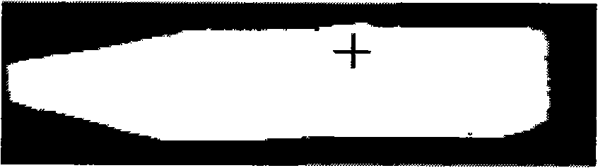
[0035] (1.1) Utilize the simulation software to make the target template (binary image), and identify the target template interest point coordinates;

[0036] (1.2) Calculate the geometric features of the target template to provide reference data for target detection and target interest point identification;

[0037] (1.2.1) Calculate the area of ​​the target template and the ratio of the long and short axes to provide reference data for target detection;

[0038] (1.2.2) Specify the head end and tail end of the long axis of the target template, and calculate the area ratio r of the two ends of the target template m (0) and r m (π).

[0039] Specify the positioning axis as the long axis of the target, and the long axis is the direction ...


PUM


Abstract

The invention comprises a method for detecting, distinguishing and locating an infrared imagery sea-surface target, which comprises the following steps: (1) detecting a remote target: firstly, a remote real-time image is preprocessed by restraining background and noise, and then is segmented so as to extract a plurality of suspected target areas; segmentation threshold is corresponding gray valueof inflection points which firstly appear in a grayscale column diagram of the real-time image; and finally a suspected target is extracted in each suspected target area and compared with a corresponding target module so as to screen out the target; (2) locating points of interest of a close-range target: firstly, a close-range real-time image is segmented so as to extract the target; a target locating shaft is obtained by utilizing standardization central moment information of the target; the target locating shaft direction is determined by distinguishing the head an the tail end of the target locating shaft, and further the points of interest of the target are located. The method has small computation workload, good real-time, high detection rate and the capability of image blur resistance, sea surface islands resistance and other man-made target interference resistance, and can be applied to a high speed maneuvering platform for detecting the target against the background of complex sea surfaces and distinguishing and locating the points of interest of the target.

Description

technical field [0001] The invention belongs to the technical field of combining digital image processing and pattern recognition, and specifically relates to a method for detecting, identifying and locating sea surface targets in infrared images, which is applied to rapid detection and recognition of sea surface targets and target interest under complex sea surface backgrounds and high-pitch-angle imaging attitudes point positioning. Background technique [0002] Target recognition technology is that the aircraft uses its own imaging sensor to obtain real-time ground scene information around the target, and uses the solidified detection and recognition algorithm program to perform necessary image processing and image analysis on the acquired real-time images. Analysis, identification and other means are used to determine the position of the target relative to the aircraft, so as to provide guidance information for aircraft navigation. [0003] For the problem of infrared t...

Claims


Application Information

Patent Timeline
Patent Type & Authority Patents(China)
IPC IPC(8): G06K9/00G01C21/24G06K9/62
Inventor 杨卫东龙睿张天序
Owner HUAZHONG UNIV OF SCI & TECH
Why Eureka
Try Eureka