Inertia/astronomy/satellite high-precision integrated navigation system and navigation method thereof

An integrated navigation system, high-precision technology, applied in navigation, mapping and navigation, navigation calculation tools, etc., can solve the problem of less research on non-equidistant output characteristic filtering

Inactive Publication Date: 2010-05-12
NANJING UNIV OF AERONAUTICS & ASTRONAUTICS
View PDF0 Cites 36 Cited by
  • Summary
  • Abstract
  • Description
  • Claims
  • Application Information

AI Technical Summary

Problems solved by technology

However, in the current inertial/astronomical/satellite integrated navigation system

Method used


Image

  • Inertia/astronomy/satellite high-precision integrated navigation system and navigation method thereof
  • Inertia/astronomy/satellite high-precision integrated navigation system and navigation method thereof
  • Inertia/astronomy/satellite high-precision integrated navigation system and navigation method thereof

Examples


Embodiment Construction

[0109] The technical scheme of the present invention is described in detail below in conjunction with accompanying drawing:

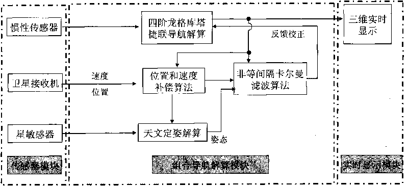
[0110] Inertial / astronomy / satellite high-precision integrated navigation system of the present invention such as figure 1 shown. The system is composed of inertial sensor, star sensor, satellite receiver, navigation computer (integrated navigation calculation module) and display computer (real-time display module). The system is fully capable of practical engineering application.

[0111] The navigation computer includes an integrated navigation calculation module, and the integrated navigation calculation module includes a fourth-order Runge-Kuta strapdown navigation calculation module, an astronomical attitude determination calculation module, a non-equidistant Kalman filter module, and a position and speed compensation module The real-time display module is composed of a three-dimensional real-time display module. Wherein the input end of the fourt...


PUM


Abstract

The invention provides an inertia/astronomy/satellite high-precision integrated navigation system and a navigation method thereof. The inertia/astronomy/satellite high-precision integrated navigation system comprises a sensor module, an integrated navigation resolving module and a real-time display module, wherein the sensor module is sequentially connected in series with the integrated navigation resolving module and the real-time display module and comprises an inertia sensor, a star sensor and a satellite receiver; the integrated navigation resolving module comprises a four-step Runge-Kutta strapdown navigation resolving module, an astronomy attitude determination resolving module, an unequal-interval Kalman filtering module and a position and speed compensation algorithm module; and the real-time display module comprises a three-dimensional real-time display module. The navigation method realizes the real-time acquisition of sensor data, utilizes the inertia sensor data to carry out strapdown navigation resolving based on a four-step Runge-Kutta algorithm and can carry out the integrated navigation resolving on the inertia sensor data, star sensor data and satellite receiver data and carry out the real-time three-dimensional display on an integrated navigation result by utilizing a projection algorithm.

Description

technical field [0001] The invention relates to a high-precision inertial / astronomical / satellite information fusion combined navigation system and navigation method, belonging to the field of combined navigation, wherein " / " represents the relationship of "and". Background technique [0002] The accuracy and stability of the navigation system are the primary indicators of the navigation system. At present, the integrated navigation technology with inertial navigation system as the core, combined with satellite navigation, celestial navigation and other systems is generally used to improve the accuracy and stability of the system. [0003] The accuracy of the strapdown inertial navigation system is the key to navigation. The strapdown algorithm should not only consider the influence of errors such as coning error and rowing effect, but also consider the influence of the strapdown period on navigation accuracy and real-time performance. The high-speed and high-dynamic situat...

Claims


Application Information

Patent Timeline
IPC IPC(8): G01C21/00G01C21/20
Inventor 于永军刘建业熊智李荣冰曾庆化高春雷
Owner NANJING UNIV OF AERONAUTICS & ASTRONAUTICS
Why Eureka
Try Eureka