Method for performing real-time measurement on track and position of satellite or aircraft

A precision measurement and aircraft technology, applied in the space field, can solve the problems of being vulnerable to attack and destruction, and achieve the effect of low operating cost, simple equipment and low cost.

Active Publication Date: 2010-06-16
NAT ASTRONOMICAL OBSERVATORIES CHINESE ACAD OF SCI +1
View PDF2 Cites 23 Cited by
  • Summary
  • Abstract
  • Description
  • Claims
  • Application Information

AI Technical Summary

Problems solved by technology

Active measurement equipment is vulnerable to attack and destruction in wartime due to the need to transmit signals

Method used


Image

  • Method for performing real-time measurement on track and position of satellite or aircraft
  • Method for performing real-time measurement on track and position of satellite or aircraft
  • Method for performing real-time measurement on track and position of satellite or aircraft

Examples


Embodiment Construction

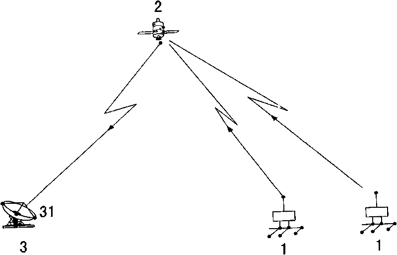
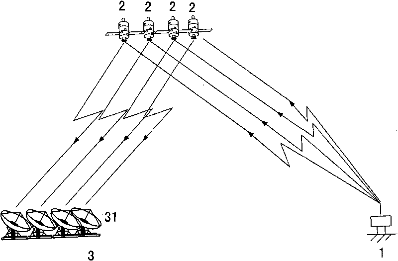
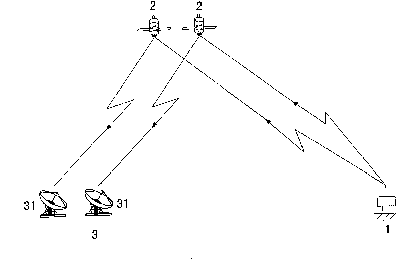
[0023] The method of the invention adopts the pseudo-range measurement principle of inverse GPS (Global Positioning System) and inverse CAPS (China Area Positioning System). The signal is transmitted in reverse, known as inbound measurement or inbound positioning. That is, the signal is sent by the measurement terminal 1, forwarded by the satellite 2, and the pseudo-range measurement is completed by the ground center station 3. If the position of the measurement terminal 1 and the pseudo-range from the measurement terminal 1 to the ground central station 3 via the satellite 2 have been accurately determined, the orbital position of the satellite 2 can be determined. In order to eliminate the time delay error in the signal transmission path, two pseudoranges (see attached figure 1 ) to get the pseudo-range difference by solving the hyperboloid equations to get the precise orbital position of satellite 2. After the orbital position is accurately determined, the precise positio...


PUM


Abstract

The invention discloses a method for performing real-time measurement on the track and the position of a satellite or an aircraft, relating to space technology. The method comprises: A) establishing a database in a ground central station; B) transmitting ranging codes and telegraph texts by ground branch microminiature measurement terminals, forwarding by the satellite, receiving by heavy aperture antennae of the ground central station to obtain the telegraph text message and the pseudo ranges between the microminiature measurement terminals and the phase center of the heavy aperture antennae of the ground central station; C) subtracting two sections of pseudo ranges which are received by the antennae on the same side of the central station by the same satellite via two adjacent microminiature measurement terminals, using the pseudo range difference to solve the observation equation to obtain the high precision position or track solution of the satellite; D) using the measured values of the pseudo ranges from the same microminiature measurement terminal to different satellites to calculate to obtain the precision positions or pseudo ranges of the microminiature measurement terminals; and E) subtracting the obtain precision positions or pseudo ranges with the predetermined precision positions or pseudo ranges of the microminiature measurement terminals to obtain deviation values, using the deviation values to perturbate the observation equation to correct the track positions of the satellites to obtain the millimeter-level position coordinate values of the satellite track.

Description

technical field [0001] The invention relates to the field of space technology, in particular to a real-time precision measurement method for satellite or aircraft orbit and position. Background technique [0002] The former Soviet Union successfully launched the world's first artificial earth satellite on October 4, 1957, ushering in a new era of human exploration and utilization of the universe. Now there are more and more man-made aircraft such as satellites, rockets, stratospheric airships, space stations, and spacecraft in space, and their applications are becoming more and more extensive. How to accurately determine the position and other motion parameters of satellites and spacecraft in space, and describe their motion trajectories has always been one of the key technologies in space technology and aerospace engineering. There are many technical methods and equipment for measuring satellites, aircraft and spacecraft in the world. The more successful methods include la...

Claims


Application Information

Patent Timeline
Patent Type & Authority Applications(China)
IPC IPC(8): G01S5/02G01S5/14B64G3/00
Inventor 施浒立韩延本李志刚杨旭海裴军尹志强
Owner NAT ASTRONOMICAL OBSERVATORIES CHINESE ACAD OF SCI
Why Eureka
Try Eureka