Comprehensive laser-measured height echo simulation method

A simulation method, laser altimeter technology, applied in the field of remote sensing detection, can solve problems such as analytical derivation cannot be carried out

Active Publication Date: 2010-12-15
WUHAN UNIV
View PDF3 Cites 26 Cited by
  • Summary
  • Abstract
  • Description
  • Claims
  • Application Information

AI Technical Summary

Problems solved by technology

However, under complex surface topogr...

Method used


Image

  • Comprehensive laser-measured height echo simulation method
  • Comprehensive laser-measured height echo simulation method
  • Comprehensive laser-measured height echo simulation method

Examples


Embodiment Construction

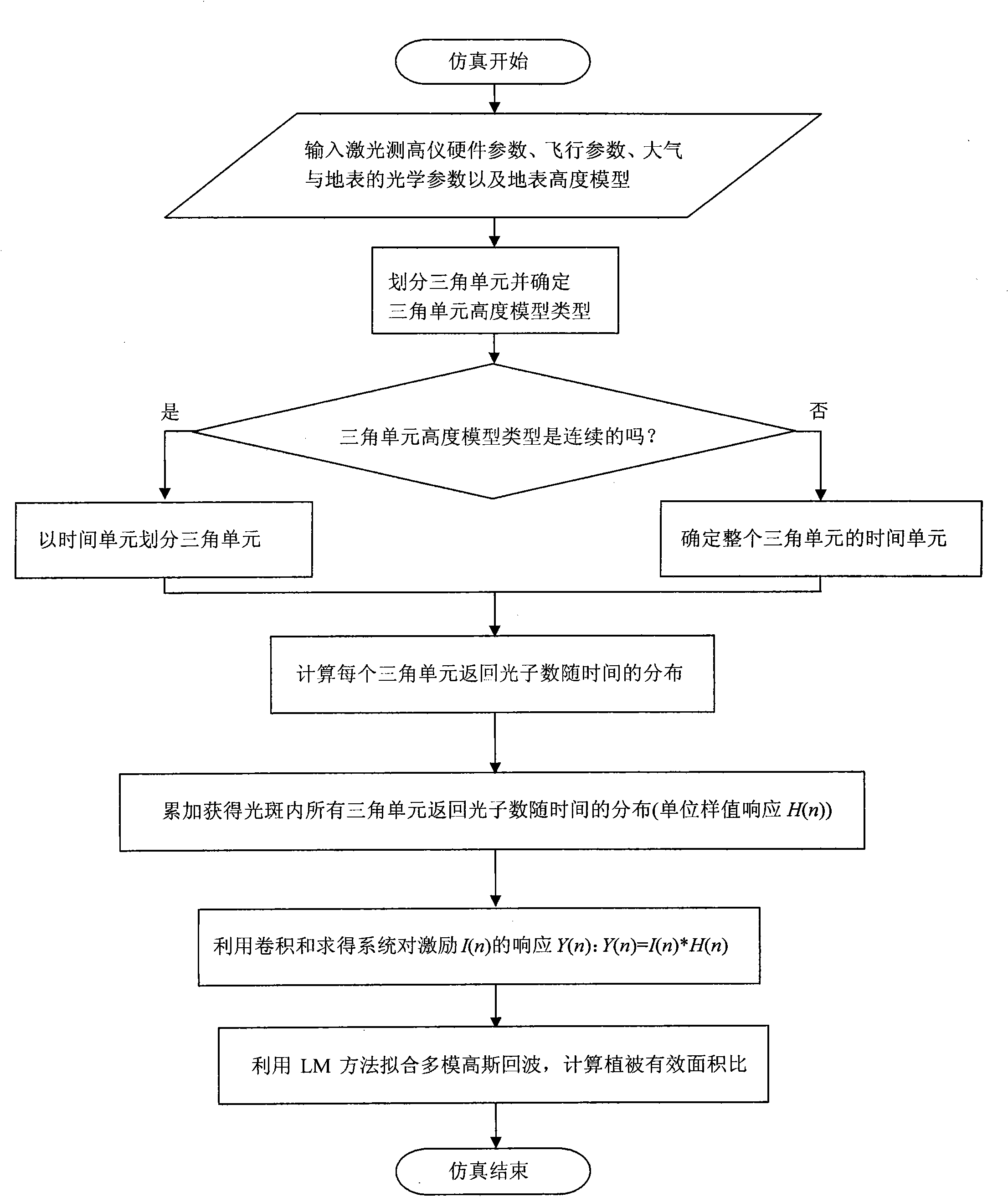
[0036] Below in conjunction with accompanying drawing, the present invention will be further described with specific embodiment:

[0037] A comprehensive laser altimetry echo simulation method provided by the present invention, such as figure 1 As shown, the following steps are taken:

[0038] (1) Input the hardware parameters of the laser altimeter;

[0039]The hardware parameters of the laser altimeter include laser wavelength, laser divergence angle, laser emission energy, laser pulse width, telescope receiving area and system transmittance. For example, for the aerospace altimeter Shuttle Laser Altimeter II (SLA-02), the corresponding hardware parameters are as follows: the laser wavelength is 1064nm; the 2 times root mean square laser divergence angle is 0.25mrad; The full width at half maximum is 15nS; the receiving area of ​​the telescope is πr 2 =0.113m 2 ; System transmittance is 50%.

[0040] (2) Input the flight parameters of the laser altimeter.

[0041] The ...


PUM


Abstract

The invention relates to the technical field of remote sensing, in particular to a comprehensive laser-measured height echo simulation method. The method can accurately simulate an echo signal produced by an oblique or fluctuant naked ground as well as the echo signal produced by a vegetation-covered ground. On the basis, simulation experiment design can be guided through the suggested concept ofvegetation cover effective area ratio so as to deduce the effect of the changes of factors such as ground fluctuation or obliqueness, vegetation thickness, a vegetation cover effective area and the like on an echo and deeply research a method for inverting terrain and ground feature parameters from a true echo signal. Lastly, the method can also consider an echo of which the laser alignment angleis not pointing to a nadir direction, but forms a certain included angle with the nadir direction.

Description

technical field [0001] The invention relates to the technical field of remote sensing detection, in particular to a comprehensive laser altimetry echo simulation method. Background technique [0002] Space-based remote sensing detection technology is an important technology in the field of earth sciences. Space-based laser altimetry is to use satellites to carry laser altimeters to detect the contours of the planet's surface from space. The working principle of space-based laser altimetry is that the space-based laser continuously emits laser light to the ground. The laser beam passes through the atmosphere and reaches the ground to generate a weak backscattered echo. The scattered echo passes through the telescope in the altimetry system of the atmosphere again. Received; the laser echo is converted into an electric pulse echo by a photodetector, and the transit time of the laser pulse is obtained by analyzing the transit time TOF (time of flight) of the electric pulse echo...

Claims


Application Information

Patent Timeline
IPC IPC(8): G01S7/48
Inventor 易帆黄春明张绍东余长明张云鹏何裕金岳显昌
Owner WUHAN UNIV
Why Eureka
Try Eureka