Steady automatic matching method for high-resolution satellite image connecting points

A satellite image, high-resolution technology, applied in the field of surveying and mapping science, can solve the problems of many wrong matching points, time-consuming and labor-intensive, etc., achieve high matching success rate, reduce workload, and improve matching reliability

A satellite image, high-resolution technology, applied in the field of surveying and mapping science, can solve the problems of many wrong matching points, time-consuming and labor-intensive, etc., achieve high matching success rate, reduce workload, and improve matching reliability

CN101915913BActive Publication Date: 2012-09-19CCCC SECOND HIGHWAY CONSULTANTS CO LTD

Image

  • Steady automatic matching method for high-resolution satellite image connecting points
  • Steady automatic matching method for high-resolution satellite image connecting points
  • Steady automatic matching method for high-resolution satellite image connecting points

Examples


Embodiment 1

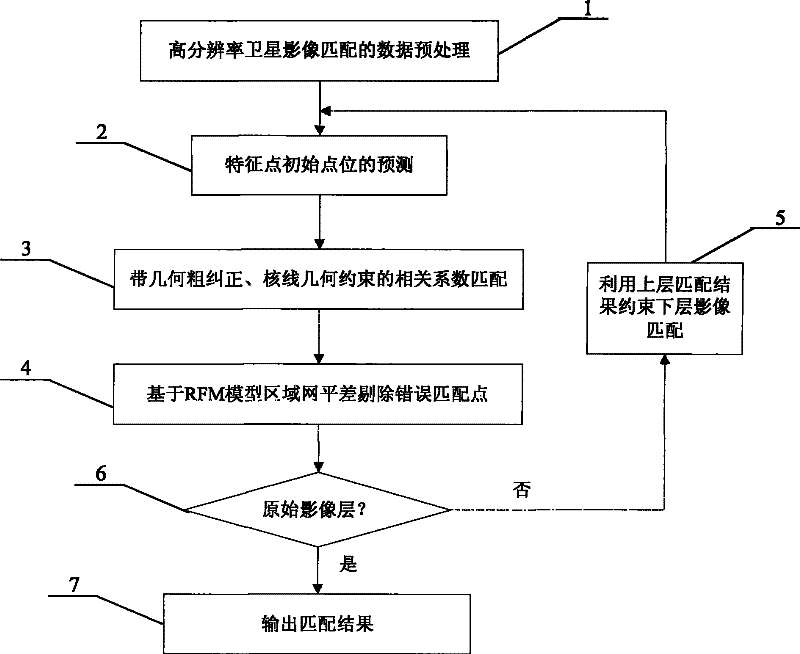
[0028] A robust automatic matching method for high-resolution satellite image tie points, the flow chart of which is shown in figure 1 As shown, each step is described in detail as follows:

[0029] The first step, data preprocessing for high-resolution satellite image matching 1

[0030] Data preprocessing for high-resolution satellite image matching mainly includes: Wallis filter image enhancement, pyramid image generation, feature point extraction and determination of each image to be matched.

[0031] Specific steps are as follows:

[0032] 1 Wallis filter image enhancement: Using the Wallis transform technology commonly used in the field of image processing, Wallis filter is automatically performed on all images to enhance the characteristics and contrast of the image and reduce the difference in gray level between images.

[0033] 2 Pyramid image generation: use the practical and simple 3×3 pixel averaging method to generate 4-level pyramid images from all images in th...


PUM


Abstract

The invention discloses a steady automatic matching method for high-resolution satellite image connecting points. The method comprises the following steps of: A, performing automatic enhancement by using Wallis filter technology, generating pyramid images of each layer and extracting the images by using feature extraction operators; B, forecasting an initial point position of identical points by using satellite image orientation parameters and upper pyramid matching results of characteristic points, establishing an epipolar geometric constraint equation, and performing geometric coarse correction on matched window images; C, removing error matched points in the matching result of the pyramid images of each layer by using an RFM model-based block adjustment method; and D, repeating the steps B, C and D till the primary image layer, and finally refining the matching result by using a double-sheet least square matching method. The method can greatly reduce the artificial editing workloadof connecting point measurement and improve the automation degree of satellite image data processing by combining block adjustment and satellite image matching, and has remarkable economic benefit and social benefit.

Description

technical field [0001] The invention belongs to the field of surveying and mapping science and technology, and more specifically relates to a robust automatic matching method for connection points of high-resolution satellite images. , to achieve automatic and reliable tie-point matching in high-resolution satellite imagery. technical background [0002] With the rapid development of earth observation technology, satellites with a resolution of less than 1m continue to emerge, such as the United States QuickBird (0.61m), WorldView-1 / 2 (0.5m), Geoeye (0.5m), etc., marking the high precision of surface information Get up from an aerial survey platform to an aeronautical survey platform. Using high-resolution satellite images, only a small number of ground control points are needed to obtain large-scale basic geographic information in a large area. High-resolution satellite images have been widely used in terrain surveying and mapping, resource investigation, disaster assessme...

Claims


Application Information

Patent Timeline
19 Sep 2012
Publication
CN101915913B
IPC
G01S7/48; G01S17/89
Inventors
明洋; 陈楚江