Method and device for expansion imaging of parameters under virtual terrain surface conditions in seismic data processing

An imaging method and surface technology, applied in seismic signal processing and other directions, can solve the problem of large underground image errors, and achieve the effect of improving accuracy and reducing errors

Active Publication Date: 2011-05-25
恒泰艾普集团股份有限公司
View PDF10 Cites 0 Cited by
  • Summary
  • Abstract
  • Description
  • Claims
  • Application Information

AI Technical Summary

Problems solved by technology

If in such an area, the shot points and receiver points of the undulating true surface are directly corrected to the

Method used


Image

  • Method and device for expansion imaging of parameters under virtual terrain surface conditions in seismic data processing
  • Method and device for expansion imaging of parameters under virtual terrain surface conditions in seismic data processing
  • Method and device for expansion imaging of parameters under virtual terrain surface conditions in seismic data processing

Examples


Embodiment 1

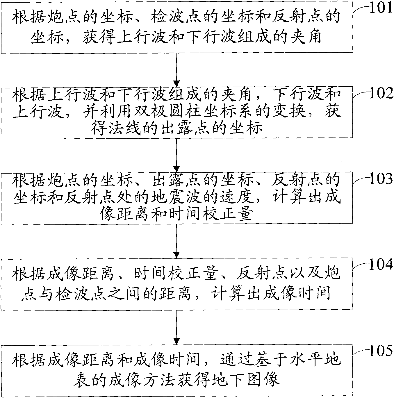
[0050] Such as figure 1 As shown, the embodiment of the present invention provides a parameter expansion imaging method under real surface conditions for seismic data processing, including:

[0051] Step 101: According to the coordinates of the shot point, the coordinates of the receiver point and the coordinates of the reflection point, the angle formed by the upgoing wave and the downgoing wave is obtained;

[0052] Specifically, according to the coordinates of the shot point, the coordinates of the receiver point and the coordinates of the reflection point, the distance between the shot point and the receiver point, the distance between the shot point and the reflection point, and the distance between the receiver point and the reflection point are calculated , and then calculate the angle formed by the up-going wave and the down-going wave through the law of cosines.

[0053] Step 102: Obtain the coordinates of the dew point according to the angle formed by the up-going w...

Embodiment 2

[0062] An embodiment of the present invention provides a parameter expansion imaging method under real surface conditions for seismic data processing. A series of shot points and receiver points are arranged in the field according to certain rules and methods in advance, and they form many pairs of shot detection pairs, among which, each pair of shot detection pairs is composed of shot points and receiver points; The seismic data of the undulating surface include seismic signal data, coordinates of shot points and receiver points and other related seismic data acquisition information.

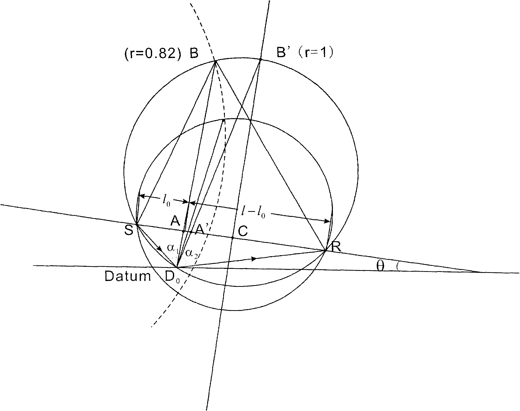
[0063] Wherein, in this embodiment, any pair of shot detection pairs is taken as an example, assuming that the shot detection pair (S, R) is taken as an example, and the coordinates of the shot point S detected by means of seismic exploration in advance are (X S , Y S ,Z S ), the coordinates of the detection point R are (X r , Y r ,Z r ), assuming that the velocity of the downgoing wave la...

Embodiment 3

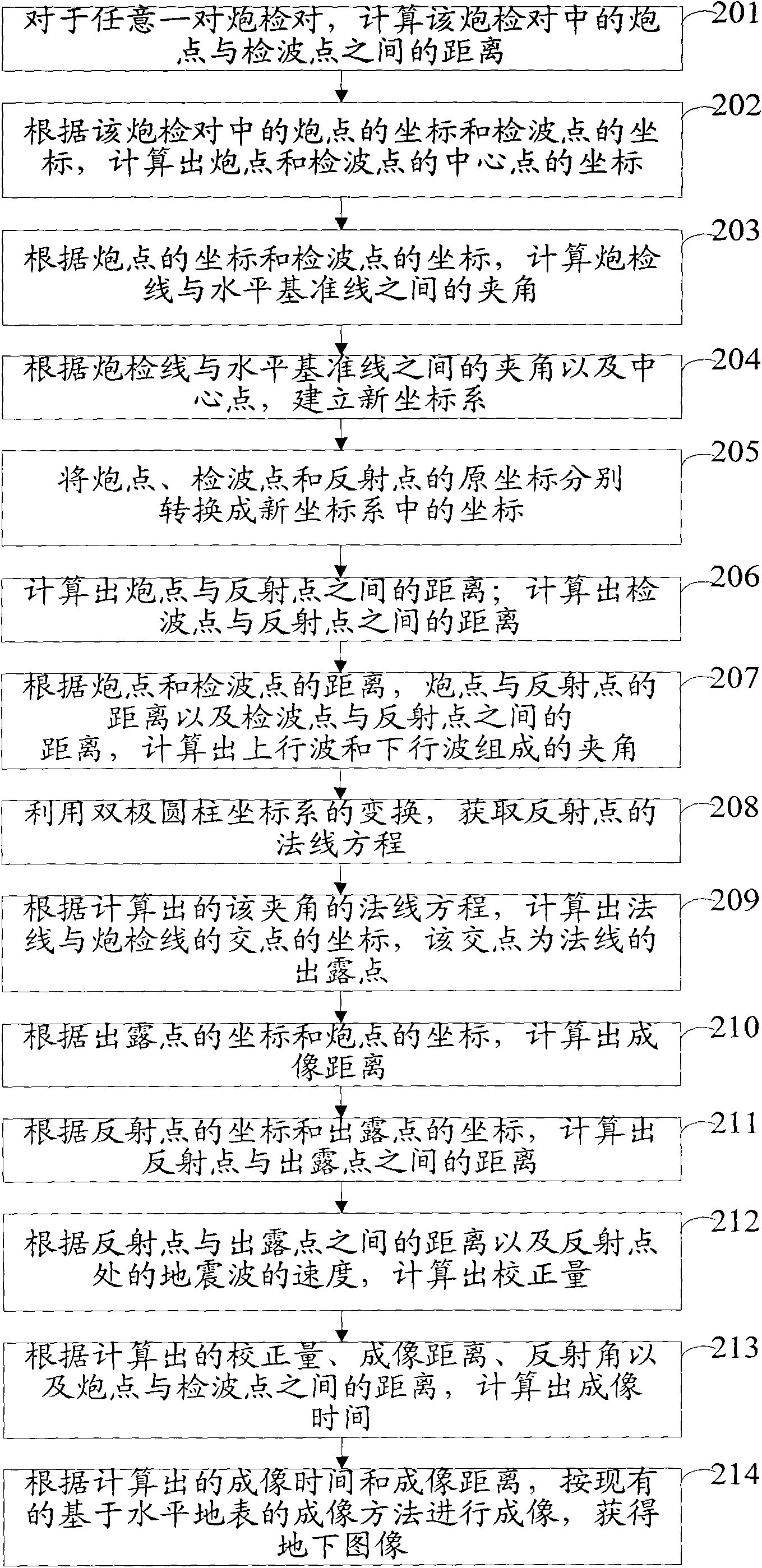
[0109] Such as Figure 4 As shown, the embodiment of the present invention provides a parameter expansion imaging device under real surface conditions for seismic data processing, including:

[0110] The first obtaining module 301 is used to obtain the angle formed by the upgoing wave and the downgoing wave according to the coordinates of the shot point, the coordinates of the receiver point and the coordinates of the reflection point;

[0111] The second obtaining module 302 is used to obtain the coordinates of the dew point of the normal line according to the angle formed by the up-going wave and the down-going wave, the down-going wave and the up-going wave, and by using the transformation of the bipolar cylindrical coordinate system;

[0112] The first calculation module 303 is used to calculate the imaging distance and time correction amount according to the coordinates of the shot point, the coordinates of the exposure point, the coordinates of the reflection point and t...


PUM


Abstract

The invention discloses a method and device for expansion imaging of parameters under virtual terrain surface conditions in seismic data processing, which belongs to the technical field of reflection seismic data processing in seismic exploration. The method comprises the following steps: obtaining an included angle formed by an upgoing wave and a downgoing wave according to the coordinates of a shot point, a demodulator probe and a reflecting point; obtaining the coordinates of the exposed point of a normal line according to the included angle formed by the upgoing wave and the downgoing wave, the downgoing wave and the upgoing wave based on the conversion of a bipolar cylindrical coordinate system; calculating imaging distance and time correction according to the coordinate of the shot point, the coordinate of the exposed point, the coordinate of the reflecting point and the speed of the seismic wave at the reflecting point; calculating imaging time according to the imaging distance, the time correction, the distance between the reflecting point and the demodulator probe and the distance between the shot point and the demodulator probe; and obtaining an underground image according to the imaging distance and the imaging time through the imaging method based on the horizontal terrain surface. The invention can improve the accuracy for obtaining the underground image of the virtual terrain surface.

Description

technical field [0001] The invention relates to the technical field of reflection seismic data processing in seismic exploration, in particular to a parameter expansion imaging method and device for seismic data processing under real surface conditions. Background technique [0002] A large number of shot detection pairs are arranged in the field according to certain rules and methods. Each shot detection pair is composed of a shot point and a receiver point. By means of seismic exploration, seismic signals are excited at each shot point and seismic signal data is detected at the receiver point. According to the detected seismic data, the method of parameter expansion imaging is used to obtain underground images, and technicians can determine the location of resources such as oil or natural gas by analyzing the underground images. [0003] Among them, the existing parameter expansion imaging methods are all based on the parameter expansion imaging method of the horizontal su...

Claims


Application Information

Patent Timeline
IPC IPC(8): G01V1/28
Inventor 谢桂生康德拉什科夫孙庚文林依华周青春
Owner 恒泰艾普集团股份有限公司
Why Eureka
Try Eureka