Object elevation vectorization method and system based on three dimensional laser scanning

A three-dimensional laser and scanning data technology, applied in the field of three-dimensional reconstruction, can solve the problems of large amount of point cloud data, difficulty in extracting features and boundaries, etc., and achieve the effect of reducing the amount of data

Active Publication Date: 2011-07-27
CAPITAL NORMAL UNIVERSITY
View PDF0 Cites 47 Cited by
  • Summary
  • Abstract
  • Description
  • Claims
  • Application Information

AI Technical Summary

Problems solved by technology

[0006] The purpose of the present invention is to solve the technical problems that the existing vectorization technology of laser scanning data is difficult to carry out due to the large amount of point cloud data, and the amount of data is close to or exceeds the memory capacity, and it is very difficult to extract features and boundaries.

Method used


Image

  • Object elevation vectorization method and system based on three dimensional laser scanning
  • Object elevation vectorization method and system based on three dimensional laser scanning
  • Object elevation vectorization method and system based on three dimensional laser scanning

Examples


Embodiment 1

[0043] Embodiment 1 is used to illustrate the implementation steps when the method of the present invention is applied to vectorizing point cloud data of a single site.

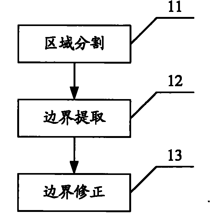
[0044] Please refer to figure 1 The method for building facade vectorization based on three-dimensional laser data provided by Embodiment 1 of the present invention includes steps:

[0045] Step 11, area segmentation, extracting functional areas such as walls, doors, and eaves from the 3D laser point cloud data on the object surface.

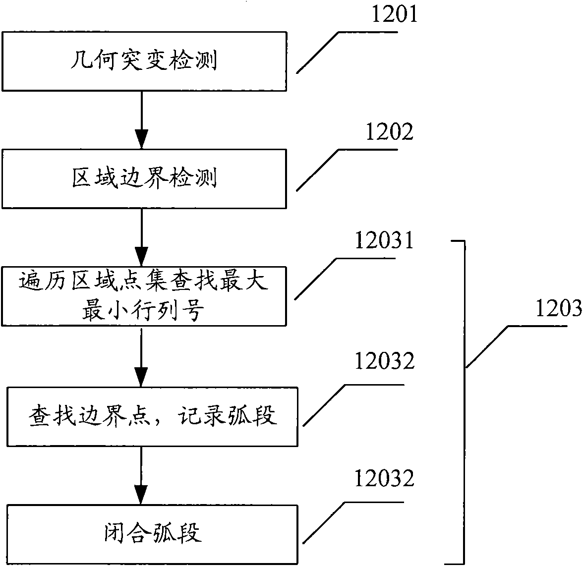
[0046] Step 12, boundary extraction, detects the boundary and geometrical mutation of the functional area.

[0047] Step 13, boundary correction, using the convex decomposition method to correct the boundary, and smoothing, to complete the surface reconstruction of the object.

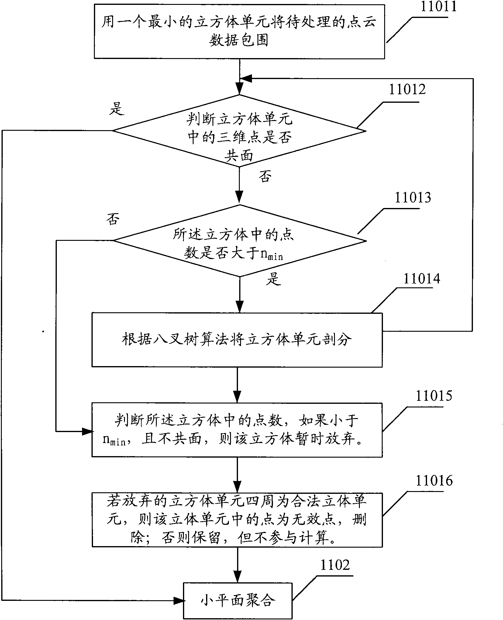
[0048] The region segmentation in the step 11 is to extract functional regions by means of facet segmentation-aggregation. Divide the image into different regions, and let different regions have diff...

Embodiment 2

[0089] Embodiment 2 is used to illustrate the implementation steps when the method of the present invention is applied to point cloud data vectorization of multiple sites. Different from the first embodiment, the step of boundary fusion needs to be added in the second embodiment. Please refer to Figure 5 , including the steps:

[0090] Step 21, area segmentation, extracting functional areas such as walls, doors, and eaves from the 3D laser point cloud data on the object surface.

[0091] Step 22, boundary extraction, detects the boundary and geometrical mutation of the functional area.

[0092] Step 23, boundary fusion, fast fusion of multi-site boundaries to form a vectorized overall description of the object surface.

[0093] Step 24, boundary correction, using the convex decomposition method to correct the boundary, and smoothing, to complete the reconstruction of the object surface.

[0094]Similar to Embodiment 1, the region segmentation in step 21 is to extract func...

Embodiment 3

[0142] Embodiment 3 provides a system for object elevation vectorization of 3D laser scanning data, which is used to implement the method described in Embodiment 1.

[0143] Please refer to Figure 7 , the system includes a laser scanning unit, a region segmentation unit, a boundary extraction unit, a boundary correction unit and a three-dimensional model drawing unit.

[0144] The laser scanning unit obtains the three-dimensional point cloud data of the facade of the object by emitting and receiving laser light.

[0145] The region segmentation unit extracts functional regions, such as walls, doors, eaves, etc., from the acquired 3D point cloud data.

[0146] The region segmentation unit includes a facet segmentation module and a facet aggregation module.

[0147] The facet segmentation module establishes a linear octree-based spatial index for the point cloud data, assigns the point cloud data into cube units, and completes the facet segmentation. All the three-dimensiona...


PUM


Abstract

The invention relates to an object elevation vectorization method and system based on three dimensional laser scanning. The method comprises the steps of regional dividing: functional regions are extracted from the cloud data of three dimensional laser points on the surface of the object through a method of small plane dividing-polymerizing; boundary extracting: geometric mutation is detected through a directional image, and then regional boundaries are used for supplementing to extract the geometric edge information of the functional regions included in the three dimensional laser points; and boundary correcting: a convex decomposition method is used for correcting the boundaries of the functional regions to complete the reconfiguration of the object elevation. The system comprises a laser scanning unit, a regional dividing unit, a boundary extracting unit, a boundary correcting unit and a three dimensional model mapping unit. The regional dividing unit extracts the functional regions from the obtained cloud data of the three dimensional laser points; the boundary extracting unit extracts the boundary information of the functional regions included in the cloud data of the three dimensional laser points; and the boundary correcting unit fits the functional regions again to correct the boundaries.

Description

technical field [0001] The invention relates to the technical field of three-dimensional spatial information acquisition and expression, and in particular to a method and system for vectorizing object facades based on three-dimensional laser scanning data and performing three-dimensional reconstruction, which are applied in remote sensing, surveying and mapping, and computer vision. Background technique [0002] Three-dimensional laser scanning technology is a high-tech technology for obtaining three-dimensional space data that began to appear in the mid-1990s. It uses high-speed laser scanning and measurement methods to quickly obtain three-dimensional coordinate data on the surface of the measured object in a large area and high resolution. After obtaining the spatial coordinates of each sampling point on the surface of the object, a collection of points is obtained, which is a large amount of spatially discrete lattice data, usually called "point cloud (Points Cloud)". Si...

Claims


Application Information

Patent Timeline
Patent Type & Authority Applications(China)
IPC IPC(8): G06T17/00G01B11/24
Inventor 张爱武胡少兴宫辉力
Owner CAPITAL NORMAL UNIVERSITY
Why Eureka
Try Eureka