
Horizontal well logging while drilling geo-steering method

A logging-while-drilling and geosteering technology, which is applied in boreholes/well components, measurement, directional drilling, etc., can solve problems such as large formation dip angle, late arrival time, high vertical depth, etc., and achieve simple operation, easy realization, Effects in simple steps

Inactive Publication Date: 2011-08-03
邱世军
View PDF1 Cites 73 Cited by
  • Summary
  • Abstract
  • Description
  • Claims
  • Application Information

AI Technical Summary

Problems solved by technology

[0004] On the other hand, due to the limitations of current technology, in actual drilling operations, each tool also has its shortcomings: 1) There is a distance between the logging-while-drilling tool and the drill bit, so there is a lagging well in the logging-while-drilling tool The measurement blind zone at the bottom of the well can only measure the natural gamma ray and the deep and shallow lateral resistivity at the position of the instrument; there is also a certain distance between the measurement while drilling tool and the drill bit, so the measurement while drilling tool has a measurement blind zone lagging behind the bottom of the well, which can only be measured The well inclination and azimuth of all positions of the instrument are measured; 2) There is also a late arrival time and other uncertain factors in the on-site comprehensive mud logging data, and the instrument cannot reflect the relevant conditions at the bottom of the well in a timely and accurate manner
[0006] "Horizontal Well Drilling Natural Gamma Geosteering Method" (publication number CN101476463A) patent proposes a solution, but there are deficiencies in this patent: 1) "Horizontal Well Drilling Natural Gamma Geosteering Method" (publication number CN101476463A) patent It is required that the preliminary topographical survey can accurately grasp the detailed stratum conditions of the location of the construction well, which is difficult to achieve. In practice, the stratum conditions of the location of the construction well in the design are calculated based on the data of adjacent wells and seismic data, which is often compared with the actual situation There are deviations in the situation, the vertical depth is too high or low, and the formation dip angle is too large or too small; 2) Due to the complexity of the underground geological conditions, the site is affected by many factors, and the natural gamma ray does not always reflect the real formation conditions. Determining formations by combining with multiple geosteering methods

Method used


Image

  • Horizontal well logging while drilling geo-steering method
  • Horizontal well logging while drilling geo-steering method
  • Horizontal well logging while drilling geo-steering method

Examples


Embodiment Construction

[0038] The present invention will be further described below in combination with specific embodiments.

[0039] A logging-while-drilling geosteering method for a horizontal well according to the present invention is characterized in that the method includes the following steps.

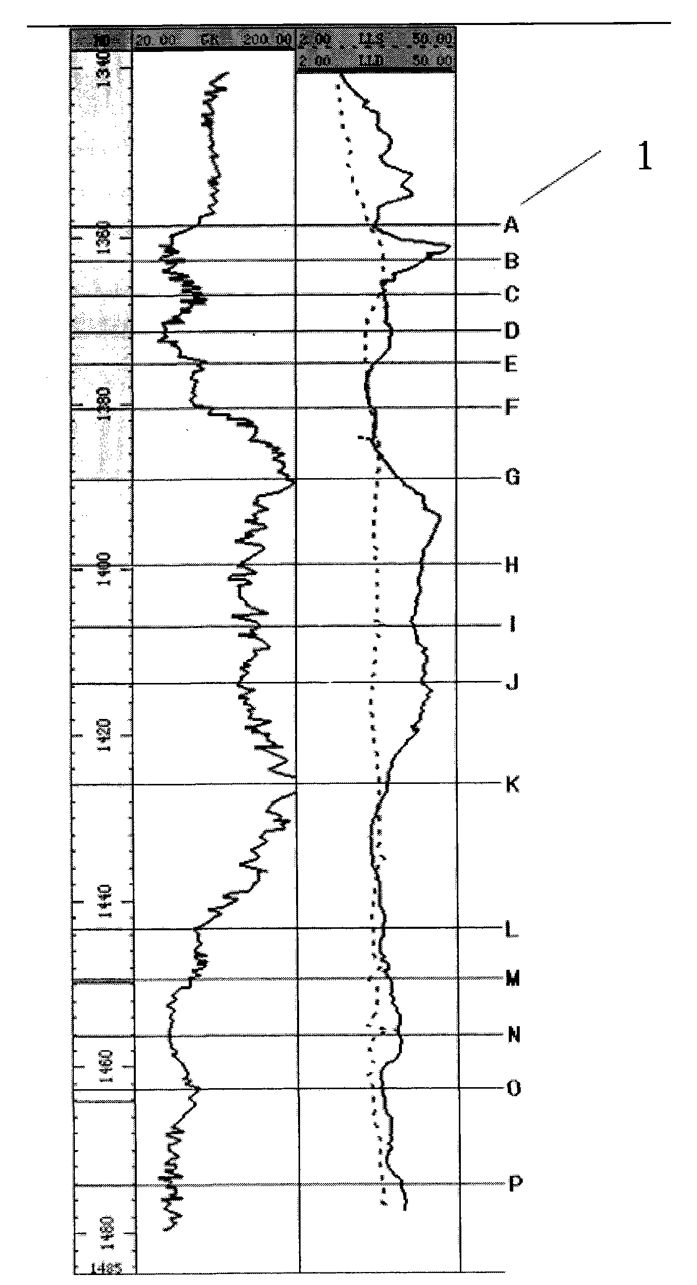
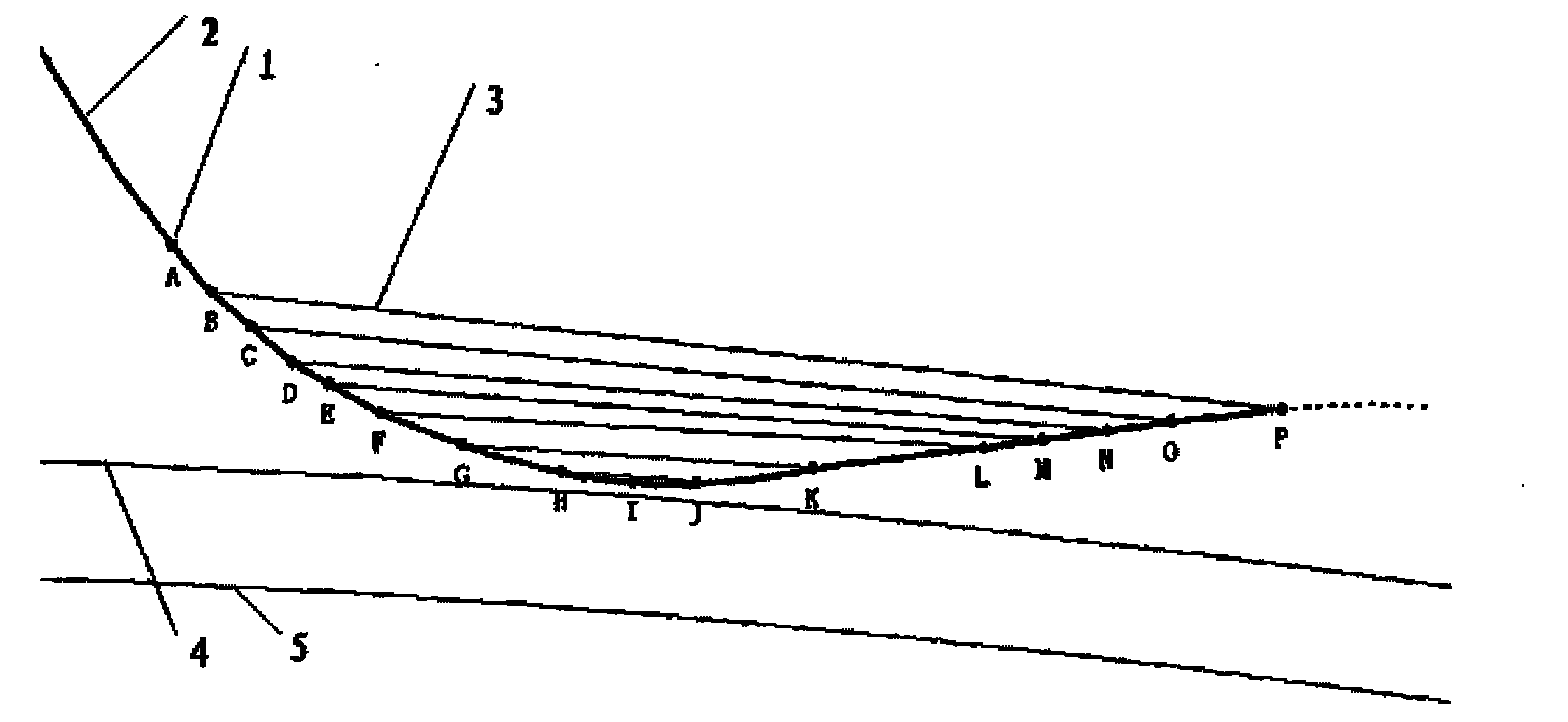
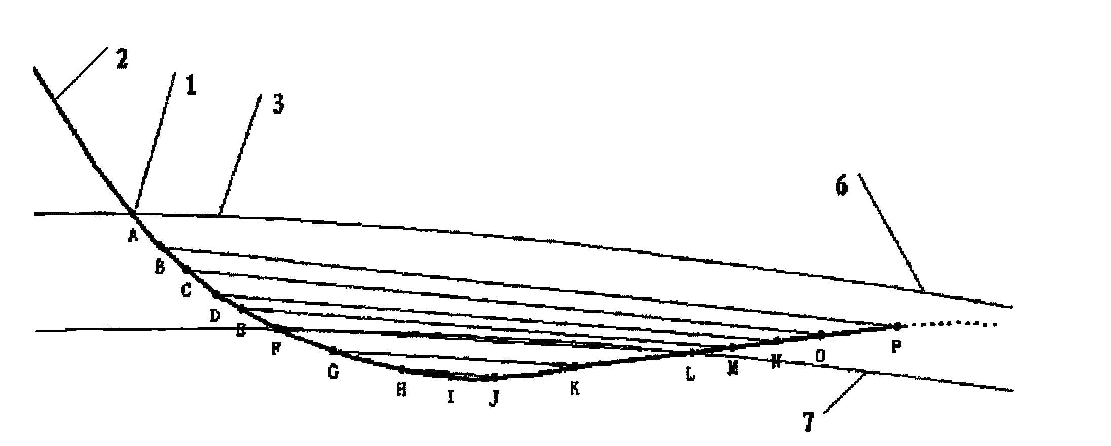
[0040] Step 1: Create well logging curves and wellbore trajectory profiles. During the horizontal drilling process of the drill bit in the target layer, downhole measurement while drilling tools and logging while drilling tools will measure data including well deviation, azimuth, natural gamma ray, Deep and shallow lateral resistivity, real-time wireless transmission to ground equipment, enter professional software, apply professional software to interpret the obtained real-time data, and make well logging curves and wellbore trajectory profiles.

[0041] In this embodiment, the natural gamma ray detection point of the LWD tool is 9 meters away from the end of the drill bit, the deep and shallow later...


PUM


Abstract

The invention discloses a horizontal well logging while drilling geo-steering method, and relates to the technical field of drilling, exploration and development of petroleum, natural gas and the like, in particular to a logging while drilling geo-steering method suitable for the drilling process of a horizontal section of a horizontal well. The method is characterized by comprising the following steps of: interpreting and making a logging curve graph and a well track profile graph by using real-time data obtained by logging while drilling and measurement while drilling, defining logging curve marking points on the logging curve graph and marking on the well track profile graph, further defining symmetrical marking points, analyzing and interpreting the symmetrical marking points to obtain the average formation dip and formation dip variation trend of each section of a well track, and redrawing a top boundary and a bottom boundary of a target layer by combining drilling points of the top boundary and the bottom boundary of the target layer; and predicting the altitude depth of a drill position according to the last measuring point, and determining the actual position of a drill in the target layer to provide a basis for next-step geo-steering decision making.

Description

technical field [0001] The invention relates to the technical field of drilling exploration and development of oil and natural gas, in particular to a logging-while-drilling geosteering method suitable for horizontal section drilling of horizontal wells. Background technique [0002] At present, in the field of drilling exploration and development technologies such as oil and natural gas, and in horizontal well operations, logging-while-drilling tools, measurement-while-drilling tools and on-site comprehensive logging tools are used. The measurement-while-drilling tool and the logging-while-drilling tool are located not far from the drill bit, and obtain various data of the formation and wellbore trajectory data while the drilling rig is drilling, including well deviation, azimuth, natural gamma ray, depth and shallow lateral resistance rate etc. The on-site comprehensive mud logging tool obtains drilling time, cuttings, fluorescence, gas logging, etc., so that the target l...

Claims


Application Information

Patent Timeline
IPC IPC(8): E21B7/04E21B47/09
Inventor 邱世军
Owner 邱世军
Learn More