Method of generating a geodetic reference database product

一种数据库、数据的技术,应用在地理信息数据库、结构化数据检索、电数字数据处理等方向,能够解决不一致、缺乏质量高程数据等问题,达到改进质量及可靠性的效果

Inactive Publication Date: 2011-11-16
TELE ATLAS NORTH AMERICA +1
View PDF1 Cites 29 Cited by
  • Summary
  • Abstract
  • Description
  • Claims
  • Application Information

AI Technical Summary

Problems solved by technology

The accuracy profiles of these datasets are inconsistent and they lack quality elevation data

Method used


Image

  • Method of generating a geodetic reference database product
  • Method of generating a geodetic reference database product
  • Method of generating a geodetic reference database product

Examples


Embodiment Construction

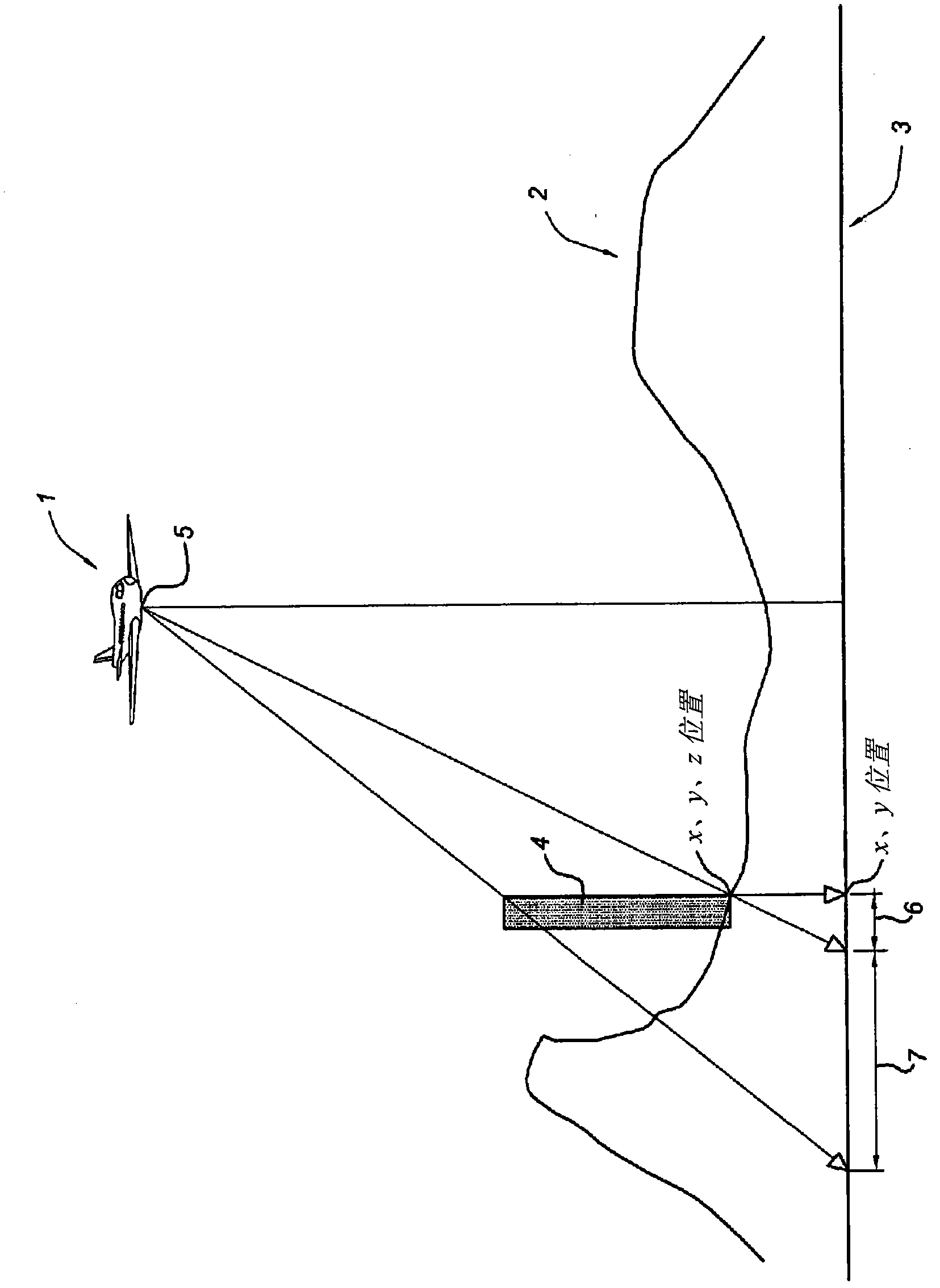
[0074] Figure 4 A simplified flow diagram of the method according to the invention is shown. The method begins with act 400 by acquiring mobile mapping data. Mobile mapping data, including simultaneously captured image data, is captured with digital cameras mounted to vehicles traveling on the Earth's surface, laser sensors such as laser scanners, and position determination components including GPS and IMUs , laser data, and associated location data in a geographic coordinate system. A vehicle equipped with position determination means, laser sensors and digital cameras for collecting mobile mapping data is called a mobile mapping system MMS. The position determining means is at least arranged to determine the position of the vehicle in a coordinate reference system and optionally with the orientation of the vehicle. It should be noted that instead of a laser sensor, any other range sensor such as LADAR, LIDAR and RADAR can be used to capture data that can be used to gener...


PUM


Abstract

A method of generating a geodetic reference database product is disclosed. The method comprises acquiring mobile mapping data captured by means of digital cameras, range sensors and position determination means including GPS and IMU mounted to a vehicle driving across the earth surface, the mobile mapping data comprising simultaneously captured image data, range data and associated position data in a geographic coordinate system. Linear stationary earth surface features are derived from the mobile mapping data by processing the image data, range data and associated position data. 3D-models are generated for the linear stationary earth surface features in the geographic coordinate system from the image data, range data and associated position data and stored in a database to obtain the geodetic reference database product. A 3D-model could include an image representing the colors of the surface of the 3D model or a set of smaller images representing photo-identifiable objects along the model. The 3D-models could be used to rectify aerial imagery, to correct digital elevation models and to improve the triangulation of digital elevation models.

Description

technical field [0001] The present invention relates to the field of generating geodetic reference database products. [0002] The invention further relates to a computer-implemented system for generating a geodetic reference database product, a geodetic reference database product, a computer program product and a computer program product or said geodetic reference database product processor-readable media. Geodesic reference database products can be useful when orthorectifying different images of the same geographic area. Background technique [0003] Ground Control Points (GCPs) are used to orthorectify satellite, aerial photography or aerial survey imagery into standard map projections. A ground control point may be any point on the Earth's surface that is identifiable on a remote sensing image, map, or aerial photograph and that can be accurately located on each of these images, maps, or aerial photographs. Ground control points have defined associated coordinates in ...

Claims


Application Information

Patent Timeline
Patent Type & Authority Applications(China)
IPC IPC(8): G06F17/30
CPCG01C11/04G06F17/30241G01S13/89G01S17/89G06F16/29
Inventor 克日什托夫·米克萨詹姆斯·黑根杰伊·克拉克
Owner TELE ATLAS NORTH AMERICA
Why Eureka
Try Eureka