
A Remote Sensing Estimation Method of Grassland Vegetation Coverage

A technology of vegetation coverage and grassland vegetation, applied in the field of remote sensing estimation of grassland vegetation coverage

Inactive Publication Date: 2011-12-21
高吉喜
View PDF1 Cites 59 Cited by
  • Summary
  • Abstract
  • Description
  • Claims
  • Application Information

AI Technical Summary

Problems solved by technology

[0006] At present, there is no case to prove the effectiveness of the method of combining vegetation index extracted from ground hyperspectral and remote sensing data to estimate grassland vegetation coverage.

Method used


Image

  • A Remote Sensing Estimation Method of Grassland Vegetation Coverage
  • A Remote Sensing Estimation Method of Grassland Vegetation Coverage
  • A Remote Sensing Estimation Method of Grassland Vegetation Coverage

Examples


Embodiment Construction

[0066] The specific implementation manner of the present invention will be described below in conjunction with the accompanying drawings.

[0067] Application examples of remote sensing estimation method for grassland vegetation coverage:

[0068] The test area of ​​the invention implementation case mainly involves the Hulunbeier Grassland. The sample plots are mainly distributed in New Barhu Left Banner, New Barhu Right Banner, Manzhouli City, Chen Barhu Banner and Ewenki Autonomous Banner.

[0069] Field measurements of the embodiments of the application of the present invention were carried out in late July and early August 2009 respectively. At this time, the vegetation was growing most vigorously. The sampling route covered the different productivity gradients of different plant communities in the Hulunbuir Grassland as much as possible. The specific setting method of sample plots and small sample plots is as follows: firstly, on the basis of analyzing TM remote sensing ...


PUM


Abstract

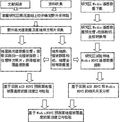
The invention discloses a remote sensing estimation method for grassland vegetation coverage, which belongs to the field of remote sensing applications. The method includes the steps of field test data collection and processing, Modis satellite data download and processing, data analysis and modeling, and precision inspection. The present invention establishes the ground spectral model for predicting vegetation coverage and corrects the Modis spectral model through ground hyperspectral tests, which is different from the methods of directly using satellite remote sensing data or using simple visual estimation and instrumental measurement and calculation in other similar researches, which helps to improve the prediction Accuracy is conducive to the scientific management and rational utilization of grassland resources, and has important practical significance for correctly evaluating the real production status of grasslands and sustainable use of grassland resources.

Description

technical field [0001] The invention relates to a method for estimating grassland vegetation coverage by remote sensing, especially a non-destructive method that can accurately and quickly determine the pattern and dynamics of grassland vegetation coverage by using ground hyperspectral data and satellite remote sensing data, which belongs to remote sensing applications field. Background technique [0002] Vegetation coverage (the percentage of the vertical projected area of ​​vegetation in the observation area to the surface area) is an important basic parameter of the ecosystem. When examining the processes of surface evapotranspiration, soil moisture, soil erosion and photosynthesis, vegetation coverage is used as It is an important control factor, and quantitative vegetation coverage information is used in many studies such as global and regional change monitoring and ecological service function assessment. The improvement of vegetation coverage measurement methods and t...

Claims


Application Information

Patent Timeline
IPC IPC(8): G01S7/48G01S17/89
Inventor 高吉喜陈艳梅吕世海冯朝阳叶生星
Owner 高吉喜
Learn More