Cloud computing-based spatial information service system

A technology of spatial information service and cloud computing, which is applied in the field of cloud computing to achieve highly feasible effects

Inactive Publication Date: 2012-03-14
江西省南城县网信电子有限公司
View PDF2 Cites 27 Cited by
  • Summary
  • Abstract
  • Description
  • Claims
  • Application Information

AI Technical Summary

Problems solved by technology

The traditional geographic information system can no longer meet the requirements, which requires the transformation of the traditional geographic information system to spatial information services, and realizes the integrated service of providing data and processing functions for multiple users in the Internet environment, so that users can directly access geographic information through the network. Access spatial data, analyze and process it and output thematic display results

Method used


Image

  • Cloud computing-based spatial information service system
  • Cloud computing-based spatial information service system
  • Cloud computing-based spatial information service system

Examples


Embodiment Construction

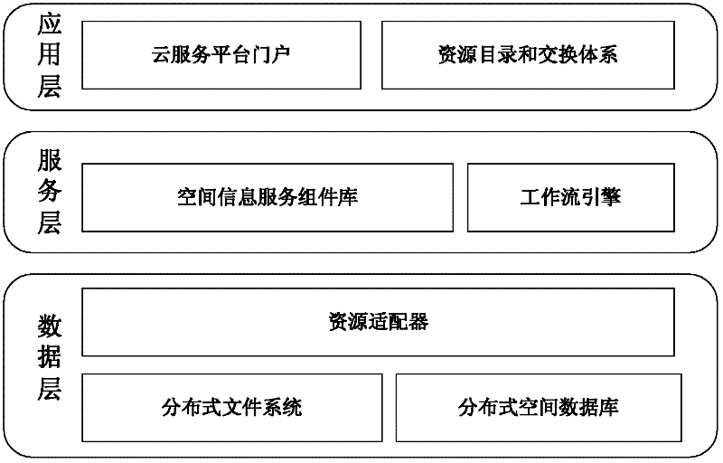
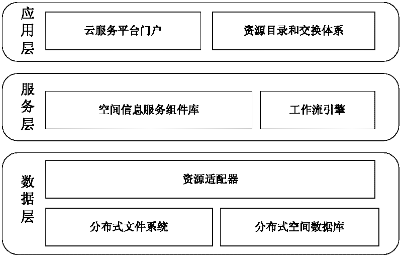
[0015] The following will clearly and completely describe the technical solutions in the embodiments of the present invention with reference to the accompanying drawings in the embodiments of the present invention. Obviously, the described embodiments are only some, not all, embodiments of the present invention. Based on the embodiments of the present invention, all other embodiments obtained by persons of ordinary skill in the art without creative efforts fall within the protection scope of the present invention. With the emergence of cloud computing technology, people have more time to pay attention to the problems in the professional field, and the spatial information service model has undergone revolutionary changes. Applying the idea of ​​cloud computing, establishing application services based on geospatial data, and realizing the AaaS concept under the cloud computing environment will greatly improve the application scope and application level of spatial information. Th...


PUM


Abstract

The embodiment of the invention discloses a cloud computing-based spatial information service system. The cloud computing-based spatial information service system comprises a data layer, a service layer and an application layer, wherein the data layer is used for storing and managing data resources; the service layer is used for encapsulating spatial information service components and performing service process modeling by using a workflow engine; the application layer is used for providing external service; the data layer consists of a distributed file system, a distributed spatial database and a resource adapter; the service layer consists of a spatial information service component library and the workflow engine; and the application layer consists of a cloud service platform portal, a resource directory and an exchange system. The cloud computing-based spatial information service system adopts the technologies of the distributed file system, the distributed database, parallel programming models and workflows and the like, supports mass data storage, the resource directory, the exchange system and parallel program processing, can provide integrated service from data to processing functions, has high feasibility and can meet various requirements of spatial information service.

Description

technical field [0001] The invention relates to the technical field of cloud computing, in particular to a cloud computing-based spatial information service system. Background technique [0002] Cloud computing is an emerging shared infrastructure that runs applications on a large number of parallel computer systems. It has the characteristics of large-scale processing, centralized management, open functions, massive storage, and lightweight clients. With its good scalability, high reliability and high availability, the cloud computing system provides a strong technical support for improving the service capability of the spatial information service system. In cloud computing, both software and hardware are abstracted into resource forms, and packaged into service forms to provide external services (infrastructure as a service, platform as a service, software as a service), no matter what kind of device the terminal is, it can Obtain services on-demand through the Internet w...

Claims


Application Information

Patent Timeline
Patent Type & Authority Applications(China)
IPC IPC(8): H04L29/08
Inventor 罗晴明罗春耕
Owner 江西省南城县网信电子有限公司
Why Eureka
Try Eureka