Star-sensor-based method for determining attitude of carrier relative to geographical coordinate system

A technology of geographic coordinate system and star sensor, applied in directions such as navigation calculation tools, can solve problems such as incomplete description of the implementation scheme, restrict engineering, and cannot achieve complete automation, and achieve the effects of low cost, high precision, and easy manufacturing.

Inactive Publication Date: 2012-04-25
BEIHANG UNIV
View PDF3 Cites 23 Cited by
  • Summary
  • Abstract
  • Description
  • Claims
  • Application Information

AI Technical Summary

Problems solved by technology

[0007] After literature search, it was found that Chinese invention patent application number 201010215336.1, title: Alignment method based on CCD star sensor, this patent involves the use of timing to obtain the conversion matrix from the equatorial inert

Method used


Image

  • Star-sensor-based method for determining attitude of carrier relative to geographical coordinate system
  • Star-sensor-based method for determining attitude of carrier relative to geographical coordinate system
  • Star-sensor-based method for determining attitude of carrier relative to geographical coordinate system

Examples


Embodiment Construction

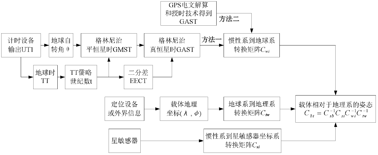
[0032] In order to better understand the technical solution of the present invention, the embodiments of the present invention will be further described below in conjunction with the accompanying drawings:

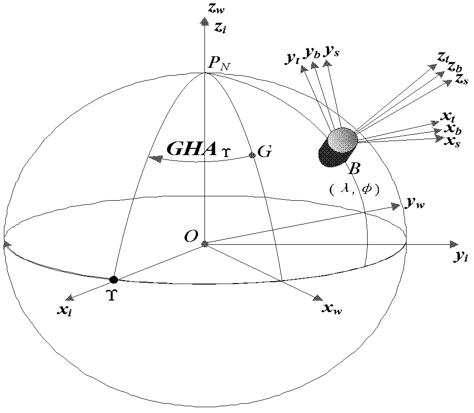
[0033] The posture establishment flow chart of the method of the present invention is as follows image 3 shown. The attitude measurement method includes the following steps:

[0034] Step 1: Calculate the conversion matrix C from the equatorial inertial coordinate system i to the WGS-84 coordinate system wi

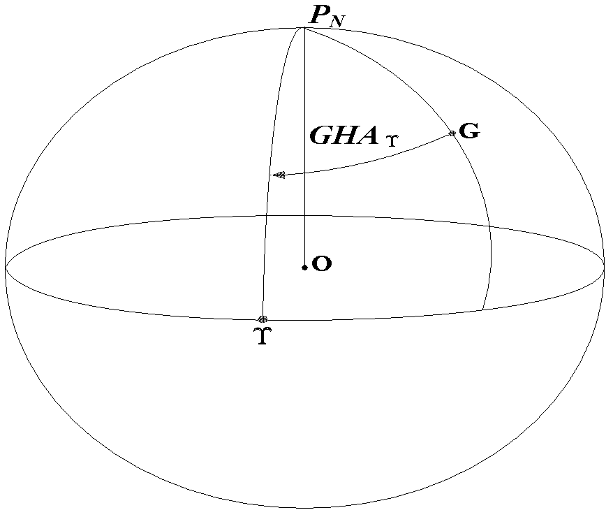
[0035] Calculate the attitude transformation matrix C wi The key is to solve GAST or GHA Υ . The specific implementation steps are as follows:

[0036] (1) Find the Earth's rotation angle θ

[0037] The universal time UT1 is obtained by using the output of the GPS timing receiver, and an important parameter can be calculated——Earth Rotation Angle ERA (Earth Rotation Angle), represented by θ,

[0038] θ=2π(0.7790572732640+1.00273781191135448T u )(1)

[0039]...


PUM


Abstract

The invention provides a star-sensor-based method for determining the attitude of a carrier relative to a geographical coordinate system. The invention belongs to the technical field of attitude measuring. First, according to a chronometer and a Greenwich sidereal time formula, or through GPS timing, a spring equinox Greenwich time angle of a measured time is obtained; a transformation matrix Cwi from an equatorial inertial coordinate system i to a WGS-84 coordinate system w is obtained by calculation; the geographical coordinate of the carrier is obtained by using external information or a locating apparatus, and a transformation matrix Ctw from the system w to a geographical coordinate system t is obtained by calculation; then a transformation matrix Csi from the system i to a star sensor coordinate system s is obtained by the star sensor; with the three attitude matrices, the attitude matrix Csb of the carrier geographical coordinate system b relative to the system t is obtained by calculation. The attitude matrix Csb is the installation constant matrix of the star sensor. According to the invention, the spring equinox Greenwich time angle is obtained based on the timing apparatus, and real-time calculation of the attitude information of the carrier relative to the geographical coordinate system is realized by computerized programs.

Description

(1) Technical field [0001] The invention relates to a method for determining the attitude of a carrier relative to a geographic coordinate system based on a star sensor, and belongs to the technical field of attitude measurement. (2) Background technology [0002] The attitude parameter of the carrier is an important parameter in the navigation system, and most of the main body uses the inertial navigation system to obtain the attitude of the carrier. Although the inertial navigation system has the advantages of mature technology, high precision, and high data output rate, there are disadvantages such as complex equipment and expensive prices, and drift problems will occur over time, so it often requires other navigation methods to assist in correcting drift . [0003] The star sensor is a high-precision attitude sensor that uses stars as the observation target to determine the absolute space attitude of the carrier relative to the equatorial inertial coordinate system. It ...

Claims


Application Information

Patent Timeline
IPC IPC(8): G01C21/20
Inventor 王海涌陆婷婷韩潮武文卿
Owner BEIHANG UNIV
Why Eureka
Try Eureka