

Method for constructing geographic coordinate system with laser tracker
A laser tracker and geographic coordinate system technology, which is applied to instruments, theodolites, optical devices, etc., can solve the problem of not having the latitude and longitude directions, and achieve the effects of high precision, easy calculation, and simple structure.
- Summary
- Abstract
- Description
- Claims
- Application Information
AI Technical Summary
Problems solved by technology
Method used
Image


Examples
Embodiment Construction
[0023] Below in conjunction with accompanying drawing the implementation of the present invention is described in further detail,
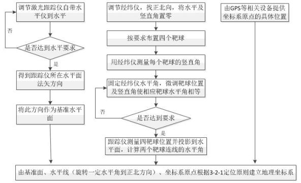
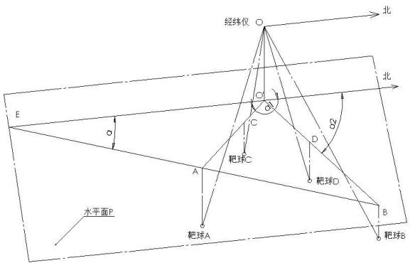
[0024] For example, measure the spatial positioning of a tank barrel in the geographic coordinate system and control the accuracy of its impact point. The measurement needs to be completed in the geographic coordinate system. Two laser trackers are used to measure the head and tail ends of the tank barrel under static and dynamic conditions to obtain its direction vector and calculate its spatial horizontal angle and vertical angle in the geographic coordinate system. . Firstly, a geographic coordinate system needs to be established for the laser tracker, such as figure 1 and figure 2 As shown, a laser tracker and a theodolite are used to establish a geographic coordinate system, and the steps are as follows:
[0025] 1) Adjust the horizontal and vertical directions of the theodolite, find the true north direction, and set the theodolite to ze...
PUM
 Abstract
Description
Claims
Application Information