Rapid map making system based on GIS (Geographic Information System) data

A map and data technology, applied in the directions of maps/plans/charts, digital data processing, special data processing applications, etc., can solve problems such as loss of data semantic information, inability to control the map data conversion process, and no system yet developed. , to reduce the processing time, shorten the drawing cycle, and improve the efficiency of map drawing

Inactive Publication Date: 2012-06-20
WUHAN UNIV
View PDF2 Cites 36 Cited by
  • Summary
  • Abstract
  • Description
  • Claims
  • Application Information

AI Technical Summary

Problems solved by technology

[0007] To solve the above problems, there are currently several commonly used methods, but these methods have their own advantages and disadvantages: (1) establish a GIS map expression model; (2) through Vector graphic formats AutoCAD DXF, Windows EMF, Adobe Illustrator AI, etc. are used as intermediate formats for indirect conversion; (3) Using the clipboard, through the interoperability between ArcGIS software and CorelDraw software, the GIS data is directly converted into CorelDraw through selective paste format data, etc.
The map expression model based on GIS organically integrates geographic data and map expression information, facilitates object-level modification and preservation of map objects, reduces data redundancy, facilitates incremental update and multiple expressions of maps, and is also convenient for traditional GIS Expand map expression capabilities, but this model is still at the stage of formal description, and no related system has been developed yet; the technical route of using GIS data to map in CorelDraw environment, its main steps are: data screening and analysis → data projection Transformation→data layering→data editing→sym...

Method used


Image

  • Rapid map making system based on GIS (Geographic Information System) data
  • Rapid map making system based on GIS (Geographic Information System) data
  • Rapid map making system based on GIS (Geographic Information System) data

Examples


specific Embodiment approach

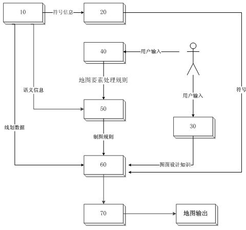
[0033] The rapid map drawing system based on GIS data of the present invention focuses on the automatic drawing process based on GIS semantic information and drawing rule base, and generates the final map through intelligent conversion of GIS semantic information, manual customization of drawing rules and system predefined drawing rules. Rules for fast mapping of GIS data. The intelligent conversion of GIS semantic information refers to the conversion of semantic information in GIS, such as feature classification, feature attributes, and feature relationships, into map feature description information in cartographic representations, such as the drawing order of map layers and the color of map features. , location information of map features, map annotation configuration rules, etc. Manually customized cartographic rules refer to the user's configuration of map file parameters through the map template configuration interface provided by the system; system predefined cart...


PUM


Abstract

The invention discloses a rapid map making system based on GIS (Geographic Information System) data. The rapid map making system based on the GIS data is used for converting the GIS data into map making data in a high-precision map data format for map making publication, and completing intelligent pre-processing of the map making data in the data conversion process by fully utilizing rich semantic information in the GIS data and map making rules predefined in the map making system. The rapid map making system based on the GIS data comprises an original GIS data reading module, a symbol library establishing module, a graphical design repository module, an element conflict process repository module, a map making rule providing module, a map data generating module and a map file input and output module. According to the invention, the GIS data is converted into the map making data, therefore, the pre-processing operation of a large amount of the map making data can be completed before the map is edited, the map making period of a digital map is shortened, and the map making efficiency and quality based on GIS data are improved.

Description

technical field [0001] The invention relates to the field of digital drawing, in particular to a fast map drawing system based on GIS data. Background technique [0002] Traditional map drawing is drawn directly on paper materials by hand. This drawing method is not only extremely inefficient, but also difficult to modify, and map updates are more time-consuming and laborious. With the development of computer technology. Computer graphics have gradually replaced manual graphics, and a large number of map design and graphics software have emerged, such as CorelDraw, Illustrator, Supermap, etc. Computer-aided cartography is based on the basic line drawing data of surveying and mapping data (measurement data or GIS data), which saves a lot of data collection work, not only improves data production efficiency, but also speeds up data update speed, which is different from traditional Compared with the drawing mode, the digital map production cycle is greatly shortened. GIS da...

Claims


Application Information

Patent Timeline
IPC IPC(8): G09B29/00G06F17/30
Inventor 蔡忠亮蒋维杰翁敏李雅彦罗康解智强
Owner WUHAN UNIV
Why Eureka
Try Eureka