Method for measuring three-dimensional terrain in river model test

A technology of river engineering model and three-dimensional terrain, applied in the field of water conservancy measurement, can solve the problems that have not been solved well, such as calculation of three-dimensional space coordinates, and achieve high-quality results

Inactive Publication Date: 2012-07-04
TSINGHUA UNIV
View PDF1 Cites 26 Cited by
  • Summary
  • Abstract
  • Description
  • Claims
  • Application Information

AI Technical Summary

Problems solved by technology

This technology has also been initially tried in the topographic measurement of river engineering models. Problems such as tracking, matching, extraction of feature points and calculation of three-dimensional space coordinates have not been well resolved.

Method used


Image

  • Method for measuring three-dimensional terrain in river model test
  • Method for measuring three-dimensional terrain in river model test
  • Method for measuring three-dimensional terrain in river model test

Examples


Embodiment Construction

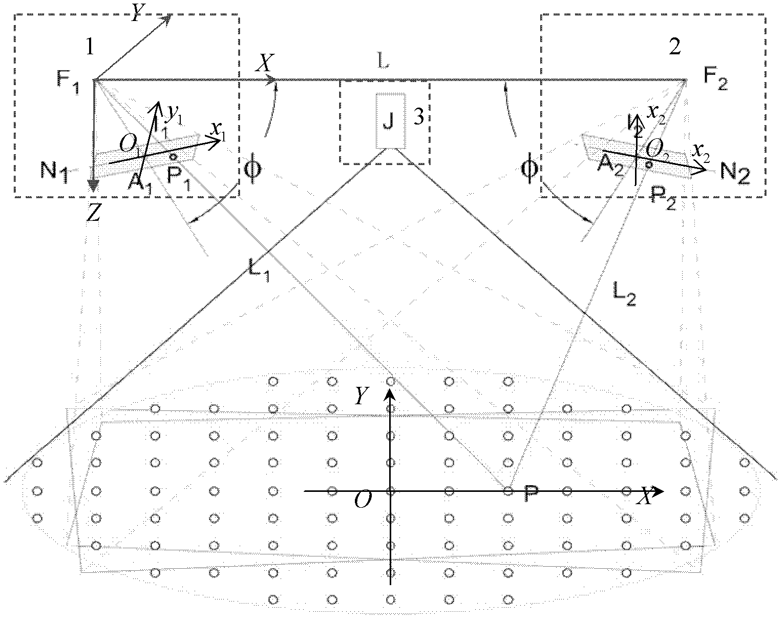
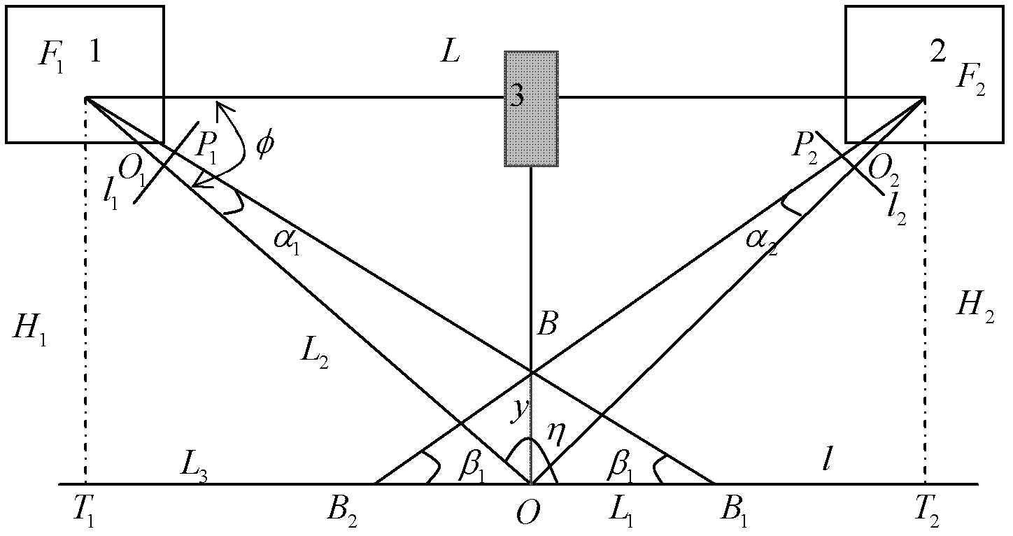
[0032] A method for measuring three-dimensional topography of a river engineering model test proposed by the present invention is characterized in that two digital cameras with the same parameters, a continuous laser rectangular lattice tracer spot emitting device, and two digital cameras respectively connected to each other are used. A computer; the continuous laser rectangular lattice tracer spot emitting device is composed of a continuous laser and a fine-tuning grating; the fine-tuning grating projects rectangular lattice tracer spots with different spacing and sizes on the bed surface of the river engineering model, wherein the rectangular lattice The center point of the dot matrix tracer spot is the positioning point O;

[0033] The method comprises the following steps:

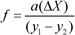
[0034] 1) First, calibrate the focal length f of the camera, the focal length L of the two cameras, and the declination angle φ of the camera:

[0035] 1-1) The calculation formula for camera focal len...


PUM


Abstract

The invention belongs to the technical field of hydraulic measurement and in particular relates to a method for measuring a three-dimensional terrain. A key technology for the river model test is characterized in that: deformation of a river channel is monitored in real time in the river model test of hydraulic engineering. The method comprises the following steps of: on the basis of a binocular stereo vision principle, by using an image pick-up technology, a laser matrix light source tracing technology and a three-dimensional terrain reconstruction technology, measuring the three-dimensional morphology of a bed surface in the river model test in real time; integrating a digital video camera, a laser rectangular lattice tracing light spot transmitting device and a computer; by installing a system in a set mode, correcting camera parameters and projecting laser lattice light spots to the bed surface, tracing the bed surface of a river model, acquiring an image of the bed surface, and extracting and matching laser tracing points of a river bed in an economic, safe and high-quality mode; by using a computational formula, computing three-dimensional space coordinates of laser tracing light spots on the bed surface; and on the basis of the computer, by taking the three-dimensional space coordinates of all laser tracing light spots on the bed surface as media, generating a terrain map of the river model.

Description

technical field [0001] The invention belongs to the technical field of water conservancy measurement, in particular to the dynamic measurement of complex three-dimensional topography in river engineering model tests. Background technique [0002] In the river engineering model test of hydraulic engineering, the topography of the river bed will change with the erosion and deposition process of the river, such as the collapse of the river bank and the ebb and flow of the side beach. Real-time monitoring of channel deformation is a key technology for river engineering model tests. [0003] Most of the existing topographic measurement technologies for river engineering models are single-point measurement. The commonly used methods generally include ① steel ruler measurement method, ② stylus measurement method, ③ photoelectric topography instrument, ④ resistive topography instrument, ⑤ ultrasonic topography instrument, etc., and The first four measurement methods are contact met...

Claims


Application Information

Patent Timeline
Patent Type & Authority Applications(China)
IPC IPC(8): G01C11/04
CPCY02A20/402Y02A90/30
Inventor 王兴奎孟震任海涛陈启刚李丹勋
Owner TSINGHUA UNIV
Why Eureka
Try Eureka