
Satellite positioning based vehicle monitoring system

A vehicle monitoring and satellite positioning technology, applied in the field of intelligent traffic control and satellite positioning, can solve the problems of low cultural level and professional quality, affecting work efficiency, prone to traffic accidents, etc., to reduce vehicle speeding phenomenon, improve work efficiency, The effect of convenient scheduling

Inactive Publication Date: 2012-07-25
CHANGSHU RES INSTITUE OF NANJING UNIV OF SCI & TECH
View PDF5 Cites 12 Cited by
  • Summary
  • Abstract
  • Description
  • Claims
  • Application Information

AI Technical Summary

Problems solved by technology

[0007] With the rapid development of the domestic tourism industry, the business volume of the car rental industry has increased significantly. The car rental industry is still in an immature growth stage. It is relatively rough in management, relatively lacking in experience, and relatively primitive in methods. Single, especially many drivers are migrant laborers, with relatively low cultural level and professional quality, and the company managers are poor in communication with these workers, task execution, cost control and many other aspects. There are more or less problems. The state, direction, and arrival time of the vehicles need to be coordinated manually. The vehicles dispatched by the company cannot be effectively arranged. It is unknown when the drivers will arrive at the destination and continue to the next itinerary. Arrangements affect work efficiency, and at the same time, it is impossible to know whether the driver is driving according to the optimal route during the work process, parking for no reason, etc., often requires the driver to call to report the specific situation, and it affects the driving speed, resulting in car rental dissatisfaction among employers, traffic accidents are likely to occur during the call, and there are also dangers

Method used


Image

  • Satellite positioning based vehicle monitoring system
  • Satellite positioning based vehicle monitoring system
  • Satellite positioning based vehicle monitoring system

Examples


Embodiment 1

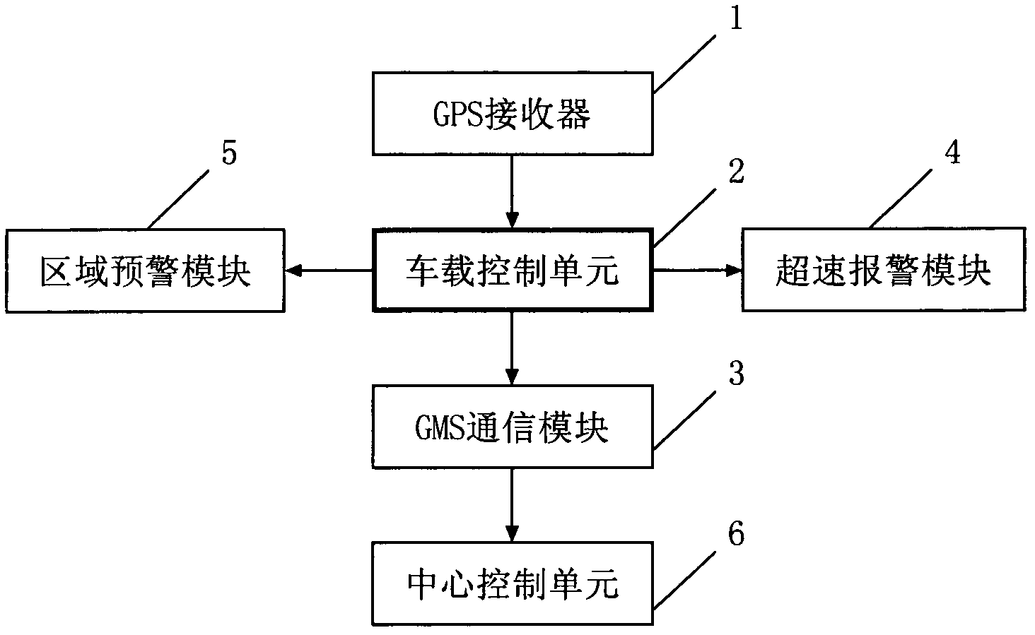
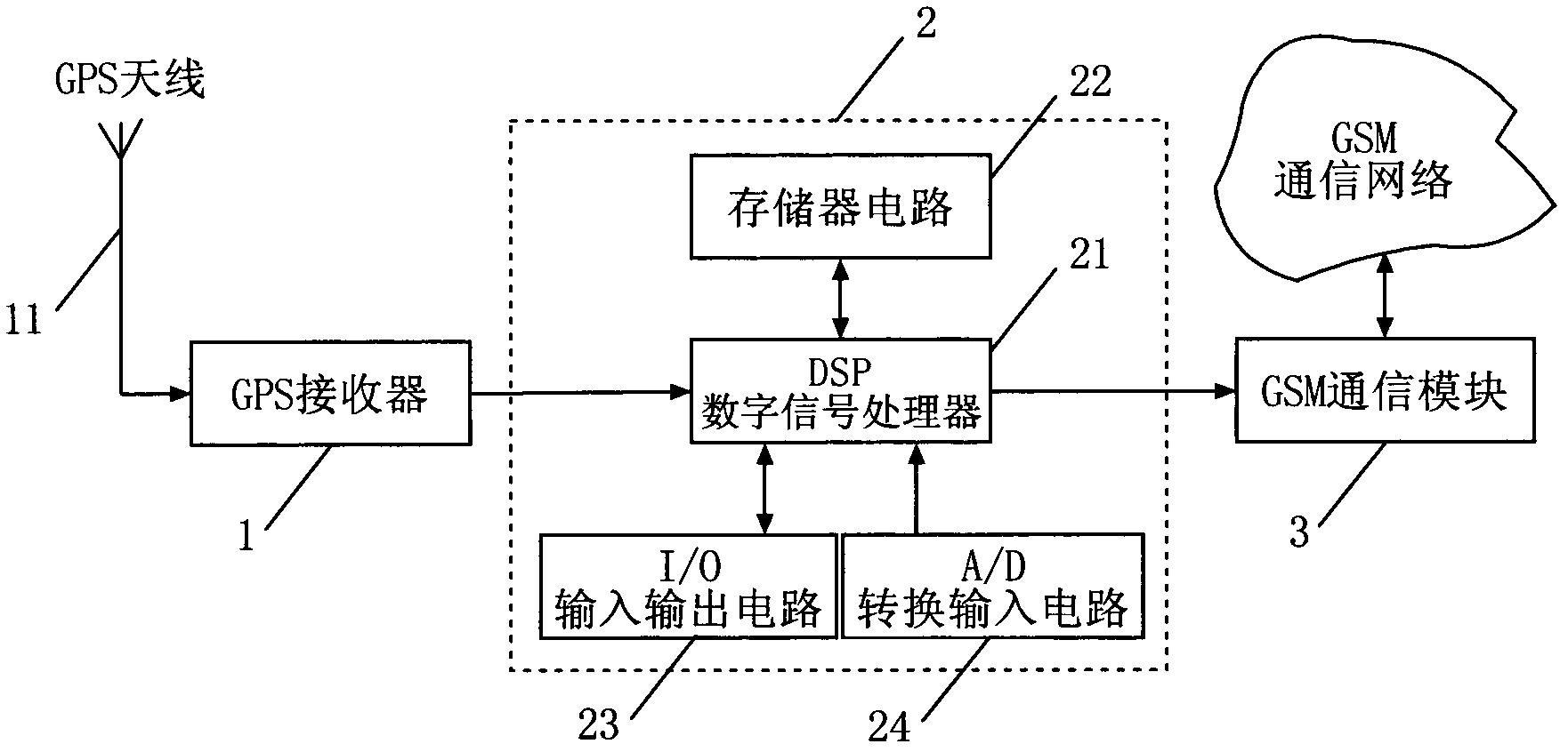
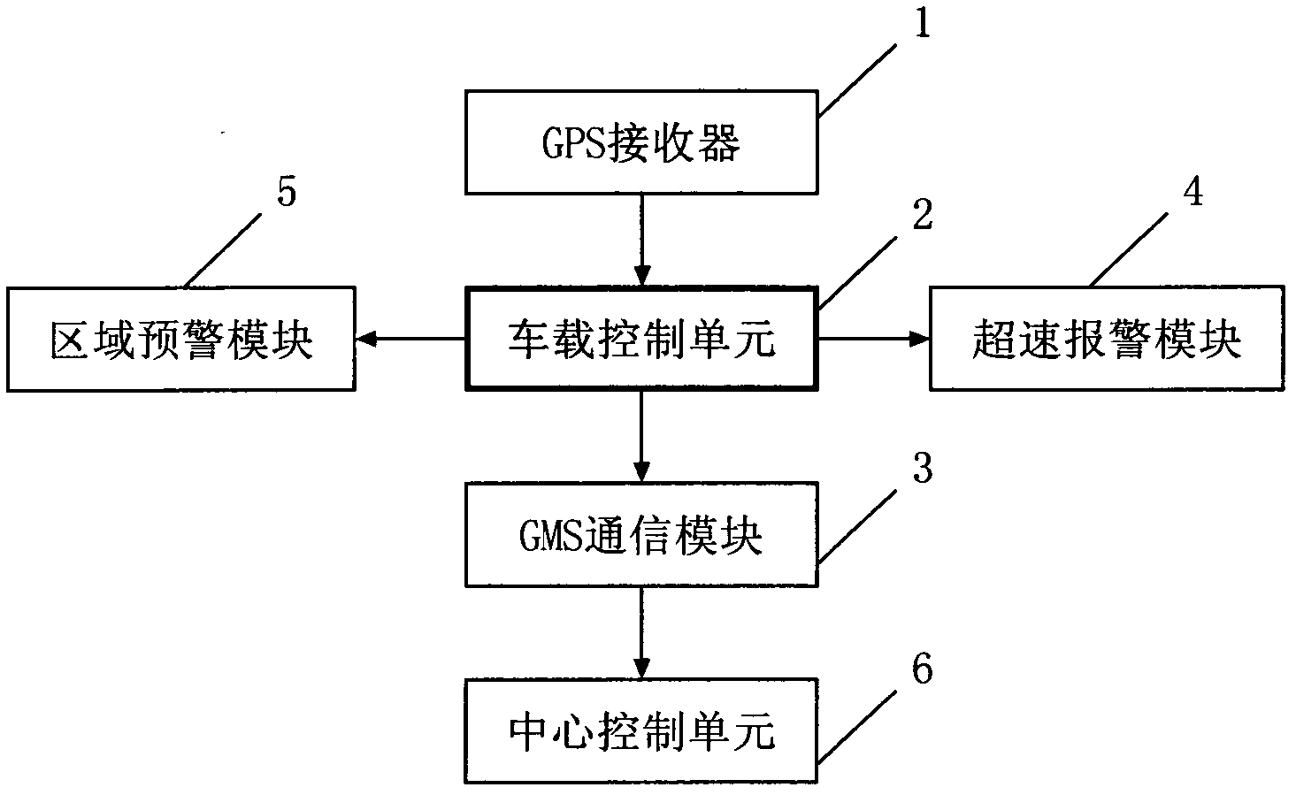
[0025] Vehicle monitoring system based on satellite positioning, its vehicle part is composed of GPS receiver, vehicle control unit, GSM communication module, overspeed alarm module, area early warning module, etc.; its main station part is composed of central control unit.

[0026] Among them, the GPS receiver, vehicle control unit, GSM communication module, overspeed alarm module, and regional early warning module are installed on the vehicle, and the central control unit is installed at the headquarters of the dispatching vehicle.

[0027] The overspeed alarm module transmits the overspeed situation of the vehicle to the central control unit in time, and sets the overspeed time value. If the overspeed time exceeds 10 minutes, the central control unit sends a prompt message. If the overspeed exceeds 30 minutes, the central control unit prompts the vehicle. The record of 30 minutes of speeding for the first time is used as the work assessment data of the car rental company for...


PUM


Abstract

The invention belongs to the technical field of intelligent traffic control and satellite positioning, and discloses a satellite positioning based vehicle monitoring system. A vehicle-mounted portion of the satellite positioning based vehicle monitoring system comprises a GPS (global position system) receiver (1), a vehicle-mounted control unit (2), a GSM (global system for mobile) communication module (3), an overspeed alarm module (4), a region warning module (5) and the like. A main station of the satellite positioning based vehicle monitoring system consists of a center control unit (6). After the GPS receiver receives GPS satellite positioning data, the GPS satellite positioning data are processed by the vehicle-mounted control unit, and coordinates of current geographic position of a vehicle can be computed, sent to a digital mobile communication network through the GSM communication module, and finally sent to the center control unit. Accordingly, the satellite positioning based vehicle monitoring system is capable of dispatching running conditions of the vehicle effectively and improving load capacity and safety thereof.

Description

technical field [0001] The invention belongs to the technical field of intelligent traffic control and satellite positioning, and more specifically relates to a vehicle monitoring system based on satellite positioning. Background technique [0002] In the late 1980s, developed countries such as Europe and the United States competed to develop intelligent transportation systems to reduce traffic congestion, increase vehicle mobility and road transportation efficiency, enhance safety, save energy and protect the environment. The main way is to use information, communication, positioning and control technologies to integrate vehicles and roads into an information network that can be installed on vehicles, optimize the vehicle flow of the entire road system to increase traffic capacity, and improve the operating safety factor of vehicles , to change the traditional transportation situation. [0003] At present, research on intelligent transportation systems mainly focuses on tr...

Claims


Application Information

Patent Timeline
IPC IPC(8): G08G1/00G08G1/127G05B19/048
Inventor 陈海勇
Owner CHANGSHU RES INSTITUE OF NANJING UNIV OF SCI & TECH
Features
  • Generate Ideas
  • Intellectual Property
  • Life Sciences
  • Materials
  • Tech Scout
  • Unparalleled Data Quality
  • Higher Quality Content
  • 60% Fewer Hallucinations
Learn More