Automatically generating method of pinchout geological body three-dimensional complex profile

An automatic generation and geological body technology, applied in image data processing, 3D modeling, instruments, etc., can solve the problem that the geological data of boreholes cannot meet the requirements of profile drawing, enrich the theory and method of spatial analysis, improve the analysis of stratigraphic space and The effect of decision-making efficiency

Inactive Publication Date: 2012-08-29
中冶沈勘工程技术有限公司 +1
View PDF2 Cites 29 Cited by
  • Summary
  • Abstract
  • Description
  • Claims
  • Application Information

AI Technical Summary

Problems solved by technology

[0015] The technical problem to be solved by the present invention is to start with the processing of borehole data, and according to the spatial distribution of existing borehole data, virtual supplements can be made to the missing formation data in boreholes, and an automatic three-dimensional complex profile pinch-out geological body can be provided. The generation method can effectively solve the problem that the geological data of boreholes collected by geological exploration cannot meet the requirements of profile drawing, judge the pinch-out situation based on the stratum information of boreholes, and realize the problem of automatic drawing of 3D profiles

Method used


Image

  • Automatically generating method of pinchout geological body three-dimensional complex profile
  • Automatically generating method of pinchout geological body three-dimensional complex profile
  • Automatically generating method of pinchout geological body three-dimensional complex profile

Examples


Embodiment 1

[0050] Take the geological prospecting project of a certain city as an example. This area is a construction site in the urban area. Its terrain is relatively flat, and the ground elevation is between 47.46 and 50.30 meters. The landform type is high floodplain and ancient river channel. The project has a total of 68 drilling holes. The drilling results show that the strata constituting the site are roughly in order from top to bottom: miscellaneous fill, silty clay, silt, silty soil, silty clay, medium sand, and round gravel.

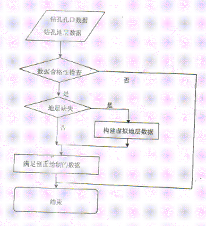
[0051] First of all, the original data is processed according to the corresponding rules, and the process is as follows figure 1 shown.

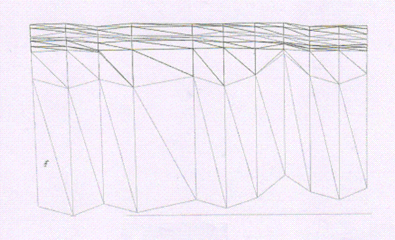
[0052] Then, the complex geological section is automatically generated and drawn in the integrated three-dimensional model system of software geological structure and surface environment developed based on the present invention. like Figure 5 The 3D model diagram of the example project, Figure 6 Combination diag...

Embodiment 2

[0054] Take a geological exploration project in a certain city as an example. This area is a construction site in the urban area. The terrain of the project site is relatively flat, with a ground elevation ranging from 49.23 to 52.71 meters. The landform unit is a river alluvial terrace. The project has a total of 127 exploration points, and the drilling depth is 10-30 meters. The results of engineering drilling show that the strata of the exploration site are roughly as follows from top to bottom: miscellaneous filling soil of Quaternary Holocene artificial accumulation layer, silty clay, fine sand, medium sand, Gravel and round gravel.

[0055] The drawing processing method and flow of the pinch-out complex 3D section in this example are consistent with the above example. like Figure 8 The overall rendering of the 3D model of the example project, Figure 9 is the complex 3D profile of a single survey line in this example, Figure 10 A combined diagram automatically draw...


PUM


Abstract

The invention provides an automatically generating method of pinchout geological body three-dimensional complex profile, which performs virtual supplementation to missed stratigraphic data in drilling holes by starting from processing the data of the drilling holes and according to the space distribution of the data of the drilling holes. The method comprises the following steps of extracting the data of the drilling holes in the same layer according to a one-to-one corresponding rule of the stratum of the drilling holes, and combining the data into a profile line of the stratum; performing triangulation based on the upper and lower stratum points of the stratum formed by adjacent two drilling holes according to the extracted profile line of the stratum, thereby realizing three-dimensional visual expression for the stratigraphic section. According to the method provided by the invention, the automatic drawing problem of complex three-dimensional section is solved; the workload for hand drawing geological profile can be greatly reduced; the method is based on the stratum information of the drilling hole to identify the pinchout situation, so that the efficiency for space analysis and decision making can be improved; molding of complex geological body three-dimensional section can be adapted, and the method can be widely promoted and used in the three-dimensional geo-science modeling.

Description

technical field [0001] The invention relates to the field of three-dimensional geological modeling, in particular to a method for automatically generating complex sections of pinch-out geological bodies based on borehole data. Background technique [0002] With the development of computer technology and spatial information technology, Geographic Information System (GIS) technology has been widely used in the three-dimensional visualization of regional geological conditions. For example, GIS software based on geological databases can Generate drilling histograms, comprehensive strata histograms, ore layer comparison maps, and geological profiles in any direction, etc. These functions can provide spatially assisted decision support for geological staff. [0003] In recent years, some scholars have explored the use of different methods to achieve the drawing of borehole profiles [1~3] . Taking the coal seam as an example, Men Guizhen et al. used Excel or other programming m...

Claims


Application Information

Patent Timeline
Patent Type & Authority Applications(China)
IPC IPC(8): G06T17/05
Inventor 王家伟吴立新刘伟武少丰郭甲腾岳玉梅魏可峰敖然孔庆晓
Owner 中冶沈勘工程技术有限公司
Why Eureka
Try Eureka