Three-dimensional measurement method for tunnel rock formation attitude

A technology of rock stratum occurrence and three-dimensional measurement, applied in the field of engineering geological survey, can solve the problems of limited remote sensing image resolution and processing capacity, not suitable for large-scale, batch occurrence calculation, and has not been promoted.

Active Publication Date: 2013-07-17
CHINA RAILWAY SIYUAN SURVEY & DESIGN GRP
View PDF1 Cites 16 Cited by
  • Summary
  • Abstract
  • Description
  • Claims
  • Application Information

AI Technical Summary

Problems solved by technology

In the 1960s, the foreign theory of using aerial photographs to measure occurrences began to appear and be applied (Berger Z, Williams T H L, Anderson D W. Geologicstereo mapping of geological structure with SPOT satellite data[J].AAPG Bulletin, 1992,76, 76 (3) :101-102 .), but it has not been promoted due to the limited resolution and processing power of remote sensing images
In the 1990s, technicians began to try to determine the occurrence of rock formations using aerial stereo images (Chen Jianping, Miao Fang. A computer method for determining the occurrence of rock formations using aerial stereo images[J]. Remote Sensing for Land and Resources, 1991,10(4): 40-45.CHEN Jianping, MIAO Fang.The calculation method for layer attitude with airphoto pair[J]. Remote Sensing for Land & Resources, 1991, 10(4):40-45.), such methods can obtain higher Accuracy, but there are disadvantages such as high acquisition cost and long processing cycle of aerial stereo images, and it is not suitable for large-scale and batch production calculations

Method used


Image

  • Three-dimensional measurement method for tunnel rock formation attitude
  • Three-dimensional measurement method for tunnel rock formation attitude
  • Three-dimensional measurement method for tunnel rock formation attitude

Examples


Embodiment Construction

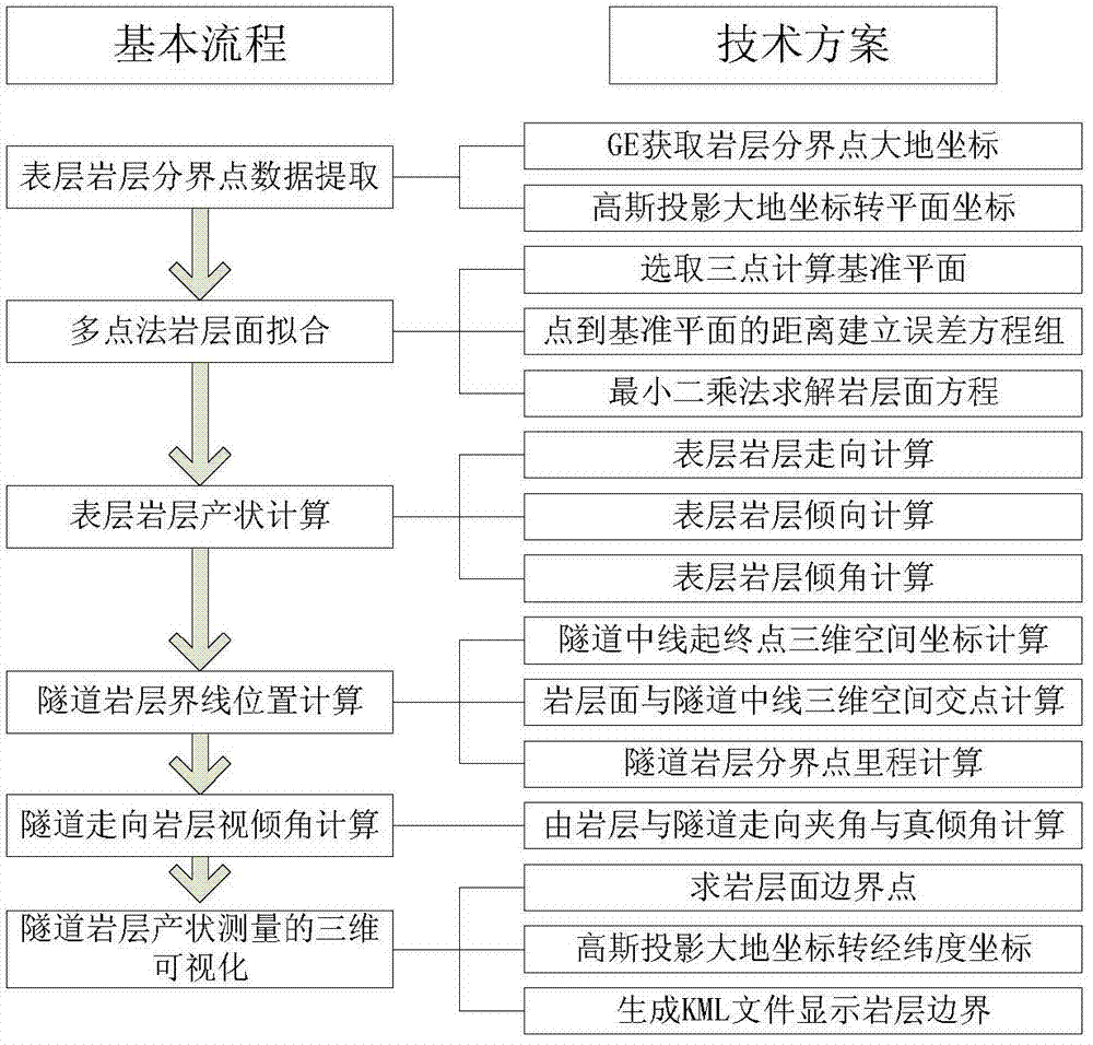
[0043] Below in conjunction with accompanying drawing and embodiment the present invention is described in further detail:

[0044] Such as figure 1 The three-dimensional measurement method for the occurrence of tunnel rock strata is characterized in that it comprises the following steps:

[0045] Step 1: In the Google Earth software database, manually select the geodetic coordinates of a plurality of boundary points of the surface rock formations to be measured, and the selected number of boundary points of the surface rock formations to be measured is not less than 3;

[0046] Step 2: using Gaussian projection to convert the geodetic coordinates of the boundary points of the surface rock layers to be measured into plane coordinates;

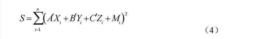
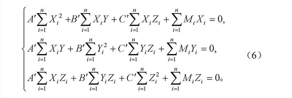
[0047] Step 3: Select three points arbitrarily in the plane coordinate system in step 2 to determine the datum plane equation:

[0048] A 0 X+B 0 Y+C 0 Z+1=0 (1)

[0049] Among them, A 0 , B 0 、C 0 is the datum plane equation coefficie...


PUM


Abstract

The invention discloses a three-dimensional measurement method for a tunnel rock formation attitude. According to the method, a large amount of geographical information data such as digital elevation models (DEM) and images, which are provided by Google Earth, serve as a data source, a Google Earth component object model application program interface (COM API) is used for obtaining rock stratum demarcation point data from the Google Earth, rock stratum surface fitting is conducted, the rock formation attitude is calculated, and rock stratum surfaces and rock formation attitude elements are displayed visually through a marking language. Compared with field surveys conducted through geological compasses, the three-dimensional measurement method for the tunnel rock formation attitude based on a Google Earth platform has the advantages that time and effort can be saved, the survey range can be expanded, rock formation attitude elements of areas with harsh natural conditions and large rock stratum span ranges can be measured conveniently, and the method is a good supplement to traditional measurement methods.

Description

technical field [0001] The invention relates to the technical field of engineering geological survey, in particular to a three-dimensional measurement method for the occurrence of tunnel rock formations. technical background [0002] Rock formation measurement is an important basic technical work in engineering geological survey, which provides basic data for the compilation of tunnel engineering geological section maps. The traditional rock stratum occurrence measurement is carried out in the field with a compass and an inclinometer, which has defects such as heavy workload, low overall accuracy, and limited by field conditions. With the development of 3D digital geospatial information technology, the rapid acquisition of large-scale terrain, landform, and surface object information based on computer and network platforms has gradually been realized, laying the foundation for the 3D spatial measurement technology of rock formations. In the 1960s, the foreign theory of usin...

Claims


Application Information

Patent Timeline
Patent Type & Authority Applications(China)
IPC IPC(8): G01V9/00
Inventor 高山冯光胜蒲浩赵新益曹柏树陈世刚岳永兴李添翼汪继锋
Owner CHINA RAILWAY SIYUAN SURVEY & DESIGN GRP
Why Eureka
Try Eureka