Image registration method based on synthetic aperture radar (SAR) image and digital elevation model (DEM) data

An image registration and image technology, which is applied in the field of image processing, can solve the problems of reduced positioning accuracy, complex solution process, and unknown height h of the target point, and achieve the effects of improving positioning accuracy, accurate positioning results, and reducing the amount of calculation

Inactive Publication Date: 2012-09-05
XIDIAN UNIV
View PDF3 Cites 28 Cited by
  • Summary
  • Abstract
  • Description
  • Claims
  • Application Information

AI Technical Summary

Problems solved by technology

[0020] Although this method can solve the defects that the positioning method based on the polynomial model has great limitations and low positioning accuracy in practical engineering applications, and the positioning method based on the collinear equation model cannot be well used in SAR image positioning.
However, most of the solutions to this positioning method use the least squares iterative algorithm, the solution process is complicated, and the height h of the target point is unknown during the solution...

Method used


Image

  • Image registration method based on synthetic aperture radar (SAR) image and digital elevation model (DEM) data
  • Image registration method based on synthetic aperture radar (SAR) image and digital elevation model (DEM) data
  • Image registration method based on synthetic aperture radar (SAR) image and digital elevation model (DEM) data

Examples


Embodiment Construction

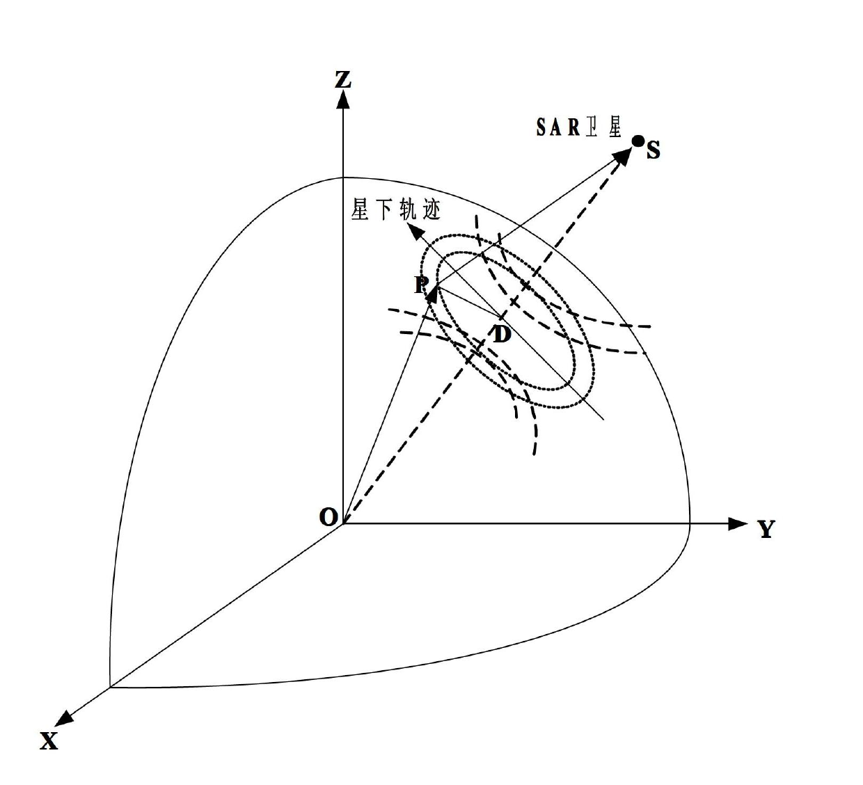
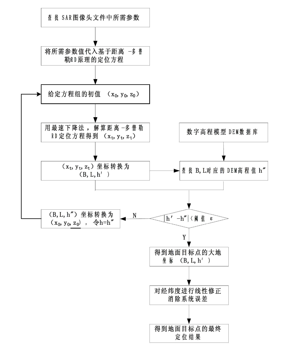
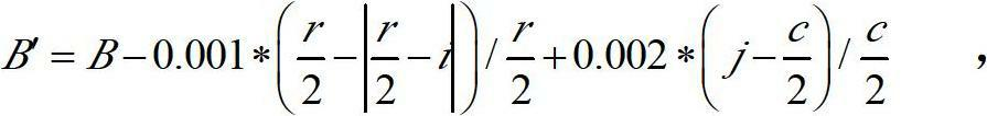
[0040] refer to figure 2 , the specific implementation steps of the present invention are as follows:

[0041] Step 1. From the parameters provided by the header file of the SAR image, find out the average elevation value h of the area where the ground target point is located in the SAR image.

[0042] Step 2. Simultaneously combine the slant distance equation, Doppler frequency equation and earth model equation determined by the range-Doppler RD principle, and use these three equations as a nonlinear equation group, and use the steepest descent method to solve the ground target point position in spherical coordinates.

[0043] 2a) Slant range equation, Doppler frequency equation and Earth model equation determined according to the principle of range-Doppler RD:

[0044] Slope distance equation: R′=|R s -R t |=[(R s -R t )·(R s -R t )] 1 / 2 ,

[0045] Doppler frequency equation: f DC = - 2 ...


PUM


Abstract

The invention discloses an image registration method based on a synthetic aperture radar (SAR) image and digital elevation model (DEM) data, wherein the problems that the positioning precision to ground target points in SAR image is not high and positioning is difficult to realize in actual projects in the prior art are mainly solved. The method comprises the following steps of: solving a longitude L, a latitude B and an elevation value h' of a ground target point in a spherical coordinate system by using a steepest descent method according to the Range-Doppler (RD) principle and the earth model equation, and transforming the values into a geodetic coordinate system; looking up the elevation value h' corresponding to B and L in a DEM database, and comparing the absolute value of h'- h' with a set threshold value epsilon, if the absolute value of h'- h' is greater than epsilon, enabling h to be equal to h' and returning to resolve the equation system again, and if the absolute value ofh'- h' is identical to or less than epsilon, stopping iteration, and taking h' as the elevation value of the ground target point, and the corresponding latitude B and longitude L as the latitude and longitude of the ground target point; linearly correcting the longitude and latitude to eliminate system errors, so that a final ground target point positioning result is obtained. The image registration method disclosed by the invention has the advantages of small operand and high positioning precision, and can be used for positioning ground target points in SAR images in actual projects.

Description

technical field [0001] The invention belongs to the technical field of image processing and relates to image registration, in particular to a ground target positioning and registration method, which can be used in the preprocessing link of the ground target positioning in SAR images and the geometric correction process of SAR images. Background technique [0002] Synthetic aperture radar (SAR) technology is playing an increasingly important role in military affairs, topographic surveying and mapping, and ocean monitoring because of its high resolution, all-weather, all-weather working ability, and target recognition characteristics. Image registration is to spatially align remote sensing digital images acquired from the same area, at the same time or at different times, from different sensors or from different viewpoints. Using the image registration of SAR image and digital elevation model DEM database, the pixel of the image can be precisely positioned. The image registrat...

Claims


Application Information

Patent Timeline
IPC IPC(8): G01S13/90G01S7/02
Inventor 于昕白朝晖赵建何焱朱建益焦李成吴建设尚荣华李阳阳
Owner XIDIAN UNIV
Why Eureka
Try Eureka