Highway reorganization and expansion surveying method

A highway, high-precision technology, used in height/level measurement, measurement devices, surveying and navigation, etc., can solve the problems of large engineering measurement workload, long operation cycle, insufficiency, etc., to increase the added value of deep processing, improve Operational efficiency and the effect of reducing construction costs

Active Publication Date: 2012-09-12
星际空间(天津)科技发展有限公司
View PDF4 Cites 26 Cited by
  • Summary
  • Abstract
  • Description
  • Claims
  • Application Information

AI Technical Summary

Problems solved by technology

[0004] (1) There are many shortcomings in engineering survey, such as heavy workload, high project cost, long operation cycle and high labor intensity, which cannot meet the requirements of low cost, short construction period, high precision and quality for survey and design work of the expressway reconstruction and expansion department. high-level requirements;
[0005] (2) Engineering surveys require field surveyors to work on the highway. In order to meet the requirements of the survey work, one method is to temporarily close the survey section to ensure the safety of the field surveyors. However, this operation method has seriously affected The normal operation of the expressway transportation management department has had a relatively large negative impact on the normal operation of the economy and society; another method is not to close the expressway, and the operators work on the expressway road surface, and only carry out warning reminders on the working section

Method used


Image

  • Highway reorganization and expansion surveying method
  • Highway reorganization and expansion surveying method
  • Highway reorganization and expansion surveying method

Examples


Embodiment Construction

[0041] In order to make the object, technical solution and advantages of the present invention clearer, the embodiments of the present invention will be further described in detail below in conjunction with the accompanying drawings.

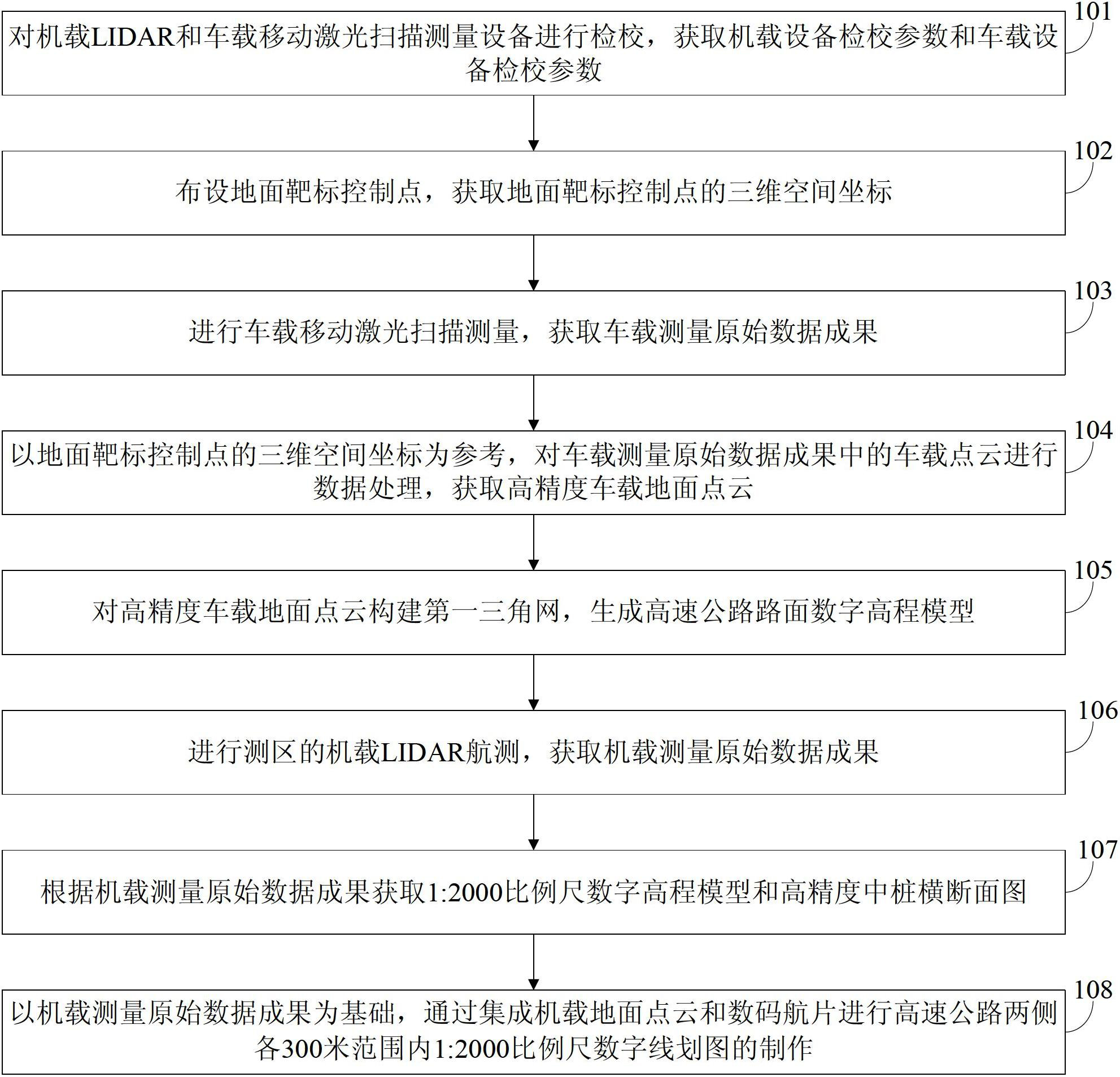
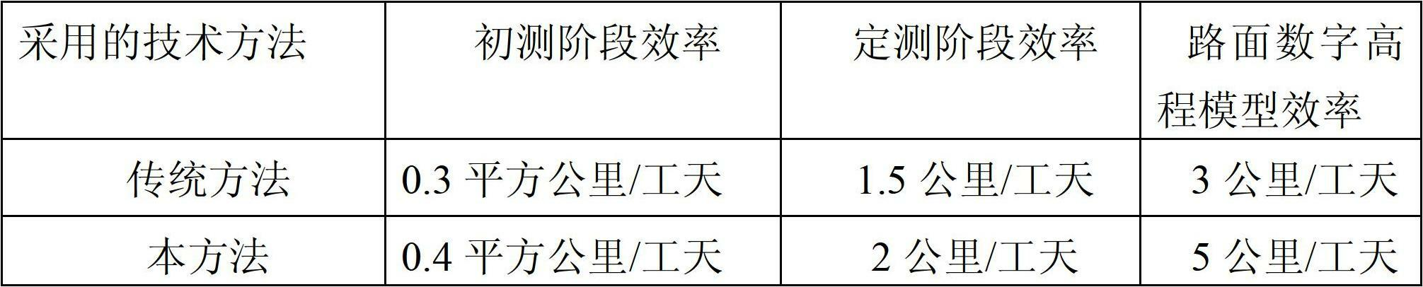
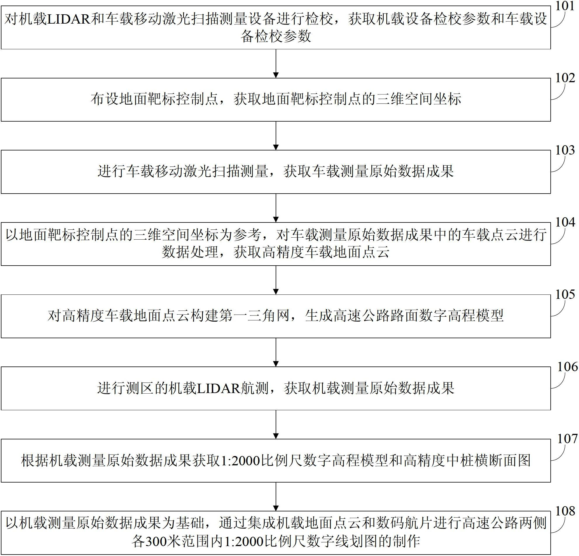
[0042] In order to improve the safety of operations, reduce project costs, shorten the development cycle, and improve the accuracy of products, see figure 1 , the embodiment of the present invention provides a highway reconstruction and expansion survey method, the method includes the following steps:

[0043] In order to solve many problems existing in the application of existing traditional surveying and mapping technology in the field of expressway reconstruction and expansion survey, improve production efficiency and deep processing added value of surveying and mapping products, the purpose of the embodiment of the present invention is to provide an integrated airborne laser radar aerial survey ( LIDAR) and vehicle-mounted mobile laser scann...


PUM


Abstract

The invention discloses a highway reorganization and expansion surveying method and relates to the fields of surveying and mapping and highway engineering design. The method comprises the following steps of: laying a ground target control point, and acquiring a three-dimensional space coordinate; performing vehicle-mounted movable laser scanning measurement, and acquiring a vehicle-mounted measured original data result; taking the three-dimensional space coordinate of the ground target control point as a reference, performing data processing on vehicle-mounted point cloud in the vehicle-mounted measured original data result, and acquiring a high-precision vehicle-mounted ground point cloud; establishing a first triangulation network for the high-precision vehicle-mounted ground point cloud, and generating a highway pavement digital elevation model; performing survey area vehicle-mounted LIDAR aerial survey, and acquiring a vehicle-mounted measured original data result; acquiring a digital elevation model and a high-precision central pile cross section map by using a 1:2000 measuring scale according to the vehicle-mounted measured original data result; and taking the vehicle-mounted measured original data result as the basis, and manufacturing digital line graphs by using the 1:2000 measuring scale in a respective 300m range on two sides of the highway by integrating the vehicle-mounted ground point cloud and digital aerial photos.

Description

technical field [0001] The invention belongs to the field of surveying and mapping and highway engineering design, and in particular relates to a survey method for expressway reconstruction and extension. Background technique [0002] With the rapid development of economy and society, the traffic capacity of expressways in the central and eastern regions has been saturated, and there is an urgent need to speed up the reconstruction and expansion of expressways. Among them, the highway reconstruction and expansion survey work is the basis and important link of the entire reconstruction and expansion work, and is closely related to the construction period, quality and efficiency of the highway reconstruction and expansion project. The highway reconstruction and expansion survey method in the prior art mainly adopts engineering survey and traditional digital aerial photogrammetry technology. [0003] During the inventor's implementation of the present invention, he found that ...

Claims


Application Information

Patent Timeline
IPC IPC(8): G01C5/00G01C11/02
Inventor 窦华成邓世军江宇李建平王国飞李新武何航程三胜闫继扬李文棋陈春明周泽兵
Owner 星际空间(天津)科技发展有限公司
Why Eureka
Try Eureka