City building complex and rendering method considering city image
A city and architectural technology, applied in the field of spatial information, can solve problems such as inflexible simplification, unfavorable simultaneous expression of geometric and texture details, and little attention to texture detail simplification.
Inactive Publication Date: 2012-09-12
BEIJING NORMAL UNIVERSITY
View PDF2 Cites 22 Cited by
- Summary
- Abstract
- Description
- Claims
- Application Information
AI Technical Summary
Problems solved by technology
[0003] Most of the current 3D architectural synthesis and rendering technologies have two shortcomings: First, they usually only express different building group models based on the main texture details. Although they can achieve smooth visual effects, they weaken the differences between urban images; Smoothing of geometric details with little attention paid to simplification of different levels of texture detail
It is worth noting that the method of taking pictures of the original building to create low-resolution textures is not only time-consuming, but also does not elastically simplify the texture of specific objects (e.g., walls, doors, windows)
This separate processing of geometry and texture is also not conducive to the simultaneous expression of geometry and texture details of different integrated images
In addition to the defects of texture synthesis, the results obtained by previous techniques are poor in portability, and the synthesis results are difficult to reuse after the architectural model is updated. The main reason is that the fixed geometry and texture information are generated. When the original architectural model is updated, the Requires a complex reintegration process to deal with the updated building and its surroundings
Among the many clustering and merging methods based on two-dimensional building footprints, some of the more popular methods can produce floor plans of building groups that take into account roads, blocks, and other elements of urban imagery. The construction synthesis process is constrained by the rapid and automatic extraction of road data
For building generalizations that do not rely on road data, the imprecision of clustering and the tortuous boundaries resulting from merging make these generalizations unsuitable for describing blocky neighborhoods
Method used
View moreImage
Smart ImageViewing Examples

Examples
Embodiment 1
[0077] The implementation was carried out on a computer configured with: Windows 7 Home Premium operating system, 2.4GHz Intel Core(TM) i5-2430MCPU, 8GB RAM, NVIDIA VS 4200M graphics card.
Login to View More PUM
 Abstract
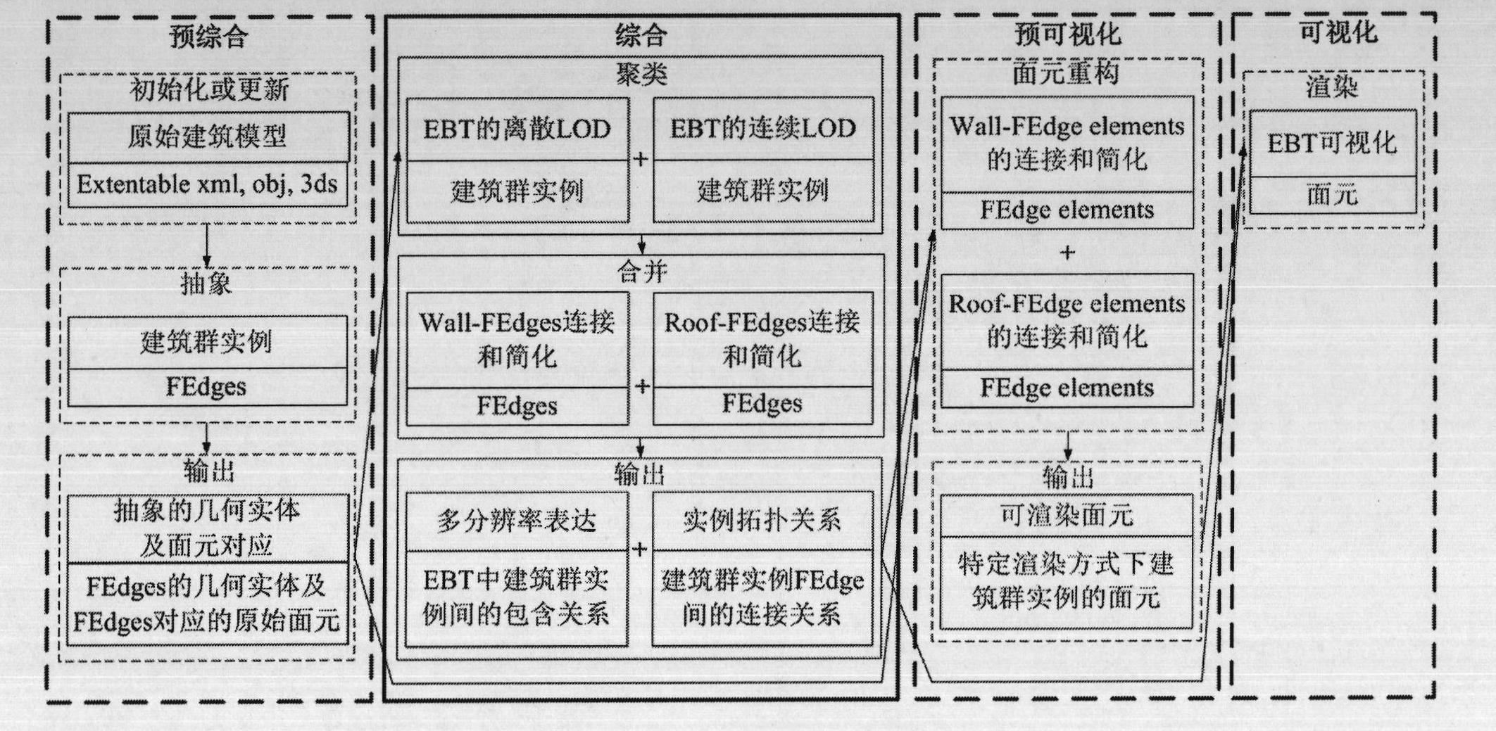
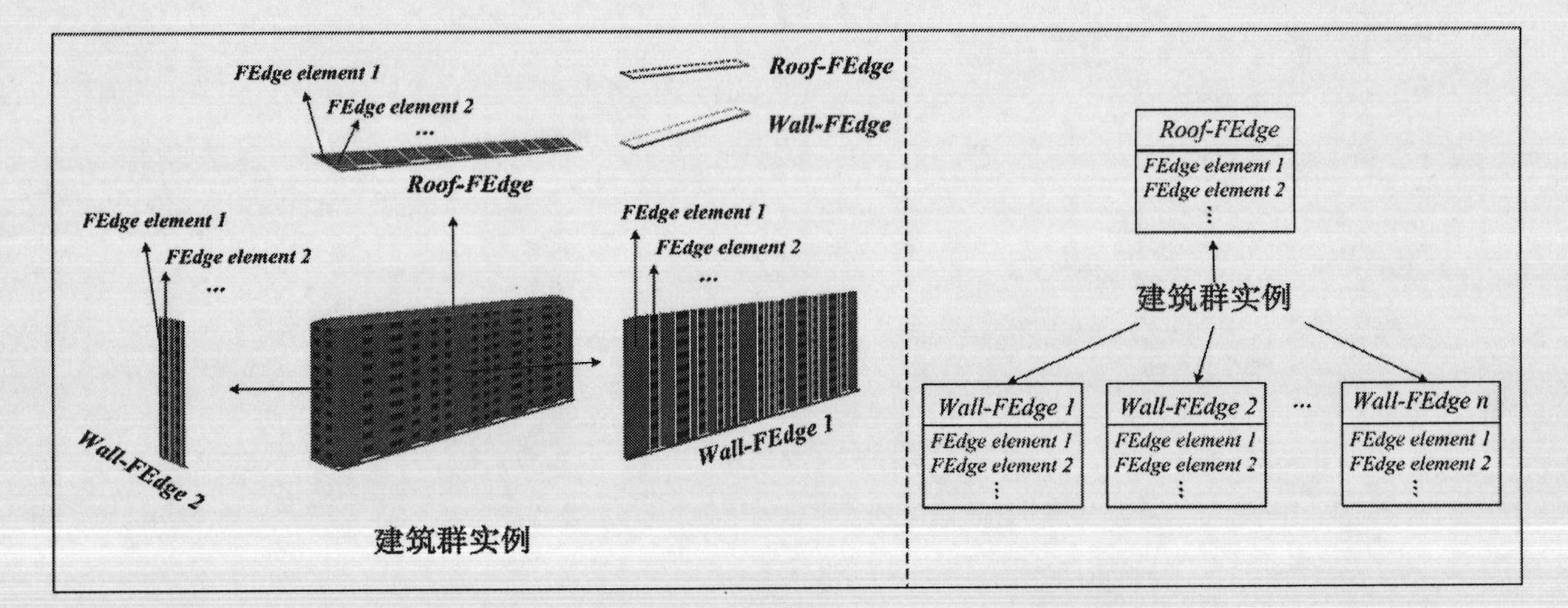
The invention relates to a city building complex and rendering method considering city image. According to the method, a fine continuous facet element in a building group model is abstracted to be an intuitive two-dimensional shape, by means of a multi-resolution expression binary tree (EBT), the city image is rendered, wherein the level of detail (LOD) of the city image is more flexible than that defined by the city geography markup language (GML) standard, and the readability and the verisimilitude of the city image are simultaneously guaranteed. According to the city building complex and rendering method considering the city image, an automatic road analysis algorithm is designed for extracting relevant space elements of the city image so as to assist grouping and combining of buildings, and by means of an indexing mechanism, an abstract edge Fedge, a building group example and the EBT are stored to serve as city building complex results so that the complex results are subjected to flexible pre-processing before the LOD scene of the city image is rendered and model updating is facilitated. The city building complex and rendering method considering the city image real-timely subjects a three-dimensional digital city model to visualized rendering and has a wide application prospect in aspects of city navigation, spatial position services and the like.
Description
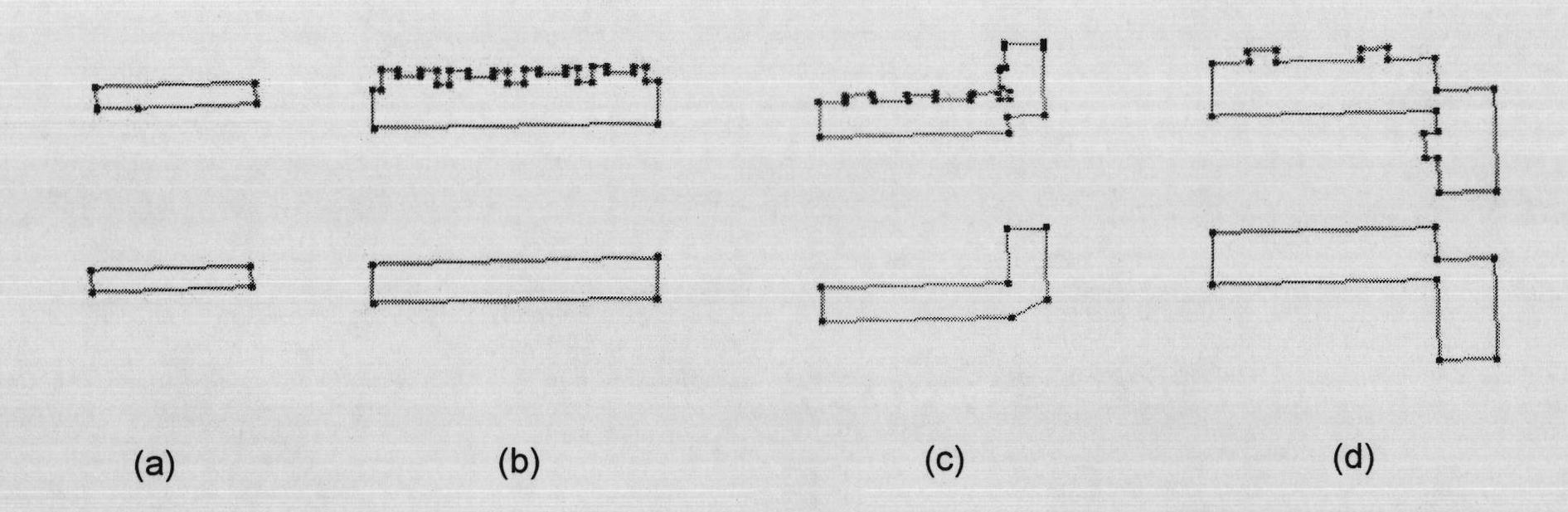
1. Technical field [0001] The invention relates to a method for synthesizing and rendering urban buildings in consideration of urban images, and belongs to the technical field of spatial information. 2. Background technology [0002] In the rendering process of large-scale complex scenes, the common visualization method is to simplify and abstract the imagery of urban scenes at different levels of detail with the help of model synthesis technology. Model synthesis involves three basic tasks: simplification, clustering and merging. The clustering of 3D buildings with multiple levels of detail plays an important role in the expression of urban imagery. According to different uses, these levels of detail can be roughly divided into two categories: discrete and continuous. Discrete level of detail representation is usually applied in tourism information systems and navigation systems. Buildings with different levels of detail have distinct appearance characteristics. These chara...
Claims
Login to View More Application Information
Patent Timeline
 IPC IPC(8): G06T15/00G06T17/00
Inventor 张立强张曼陈栋
Owner BEIJING NORMAL UNIVERSITY