
System for downsizing multi-scale geographic map in spatial information database

A topographic map and information database technology, applied in special data processing applications, instruments, electrical digital data processing, etc., can solve problems such as unsuitable mass production, quality varies from person to person, and difficult to update, and achieves convenient and universal update and maintenance. Strong, low-cost effect

Inactive Publication Date: 2012-10-31
张必胜
View PDF7 Cites 12 Cited by
  • Summary
  • Abstract
  • Description
  • Claims
  • Application Information

AI Technical Summary

Problems solved by technology

The essence of the two methods is to use drawing synthesis software to compile and draw digital maps, which have the disadvantages of low efficiency, long time, difficulty in updating, different quality from person to person, and not suitable for mass production

Method used


Image

  • System for downsizing multi-scale geographic map in spatial information database
  • System for downsizing multi-scale geographic map in spatial information database
  • System for downsizing multi-scale geographic map in spatial information database

Examples


Embodiment Construction

[0034] The present invention will be further described in detail below in conjunction with the embodiments and the accompanying drawings, but the embodiments of the present invention are not limited thereto.

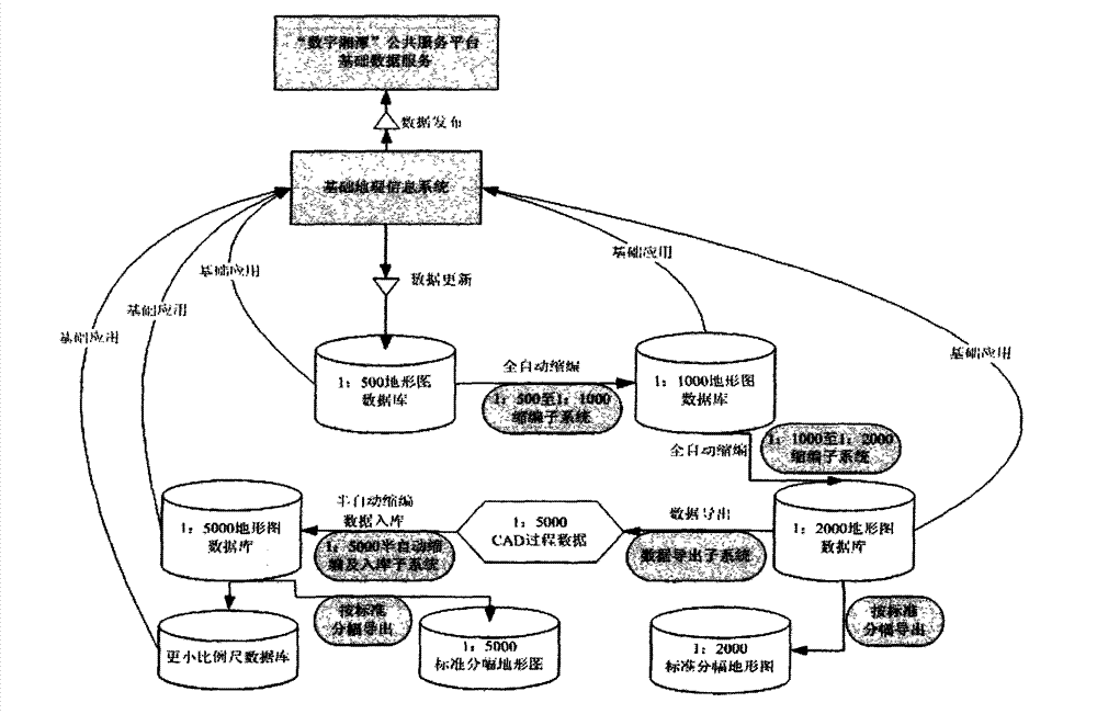
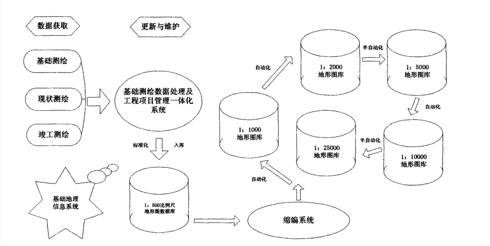
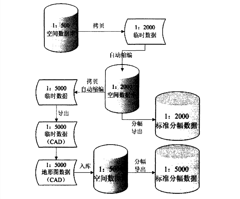
[0035] see Figure 1-4 As shown, the present invention provides a system for downscaling multi-scale topographic maps in the spatial information database. The entire process of basic topographic map data from production, management to release is essentially a process of data production, and all work is based on spatial The intelligent downscaling of the database, the 1:500 basic scale topographic map data are stored in the database through standardized processing, and the basic scale graphic database is established. Other series of scale maps are derivative products of the 1:500 basic scale topographic map. The system consists of server-side and client-side systems.

[0036] ①. Establish a series of scale graphic data standardization processing, storage, output, release...


PUM


Abstract

The invention belongs to the technical field of geographic map drawing, and particularly relates to a system for downsizing a multi-scale geographic map in a spatial information database, wherein the system comprises a server system and a client side system; the client side system is used for displaying a release geographic map; the server system comprises a geographic map database, a spatial database, a temporary database, a database system, an integrated geographic map processing database construction module, a full automatic downsizing module, a semi-automatic downsizing module, a basic geographic information module and the like; in addition, graph data stored in the database system is downsized and exchanged through an API (Application Programming Interface), wherein the data updating and the releasing to client side system are performed. The system ends the history that a series of scale geographic maps only depend on traditional surveying and mapping or digitized map compilation, overturns the traditional graphics (map sheets) downsizing technical ideas and methods, leads the map drawing to obtain a qualitative leap, has the advantages of low cost, high speed, high accuracy, strong universality and map feeding according to needs, and achieves wide social popularization and application value.

Description

technical field [0001] The invention relates to the technical field of terrain map drawing, in particular to a multi-scale topographic map reduction system in a spatial information database. Background technique [0002] Cartography is an ancient and emerging discipline. The production of topographic maps of various scales and the establishment of databases are the needs of social development and economic construction. Topographic maps of various scales are responsible for different social and economic functions. The production and database construction of multi-scale topographic maps is an important part of the construction of basic geographic information systems, and it is also the focus and difficulty of information database construction. There are generally two ways to obtain topographic map results of different scales. One method is to use modern surveying and mapping technology to carry out surveying and mapping and database building according to the scale division rul...

Claims


Application Information

Patent Timeline
Patent Type & Authority Applications(China)
IPC IPC(8): G06F17/30
Inventor 刘智新张必胜
Owner 张必胜
Learn More