Atmospheric correction method and atmospheric correction module for satellite remote-sensing image

A satellite remote sensing image and atmospheric correction technology, which is applied in the field of satellite remote sensing data processing, can solve the problems of slow speed and low atmospheric correction accuracy, and achieve the effects of improved atmospheric correction speed, high precision and practicability, and improved atmospheric correction accuracy

Inactive Publication Date: 2012-11-14
CHINESE ACAD OF SURVEYING & MAPPING
View PDF2 Cites 18 Cited by
  • Summary
  • Abstract
  • Description
  • Claims
  • Application Information

AI Technical Summary

Problems solved by technology

Through the atmospheric correction method provided by the present invention, the precise atmospheric correction of satellite remote sensing images pixel by pixel can be quickly realized, and the problems of relatively low accuracy and slow speed of traditional atmospheric correction can be overcome

Method used


Image

  • Atmospheric correction method and atmospheric correction module for satellite remote-sensing image
  • Atmospheric correction method and atmospheric correction module for satellite remote-sensing image
  • Atmospheric correction method and atmospheric correction module for satellite remote-sensing image

Examples


Embodiment Construction

[0053] In order to make the object, technical solution and advantages of the present invention clearer, the present invention will be described in further detail below in conjunction with specific embodiments and with reference to the accompanying drawings.

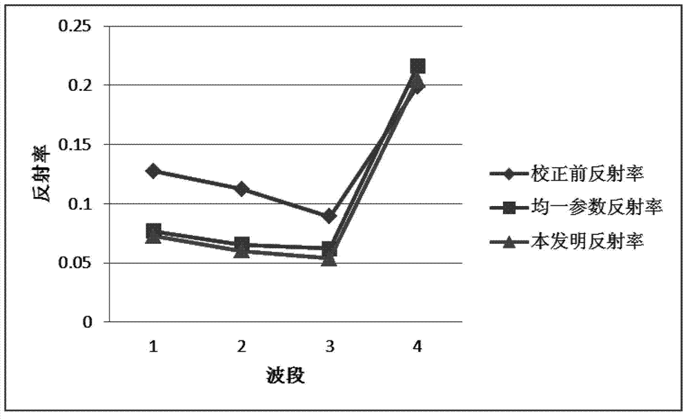
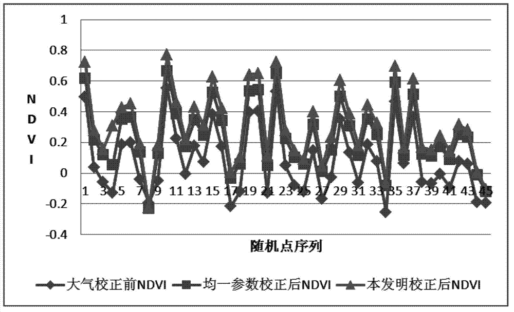
[0054] In order to improve the accuracy of atmospheric correction, the atmospheric correction method for satellite remote sensing images provided by the present invention, before performing atmospheric correction, establishes an atmospheric correction parameter lookup table LUT (Look Up Table) based on the 6S radiation transfer model, and realizes the lookup based on 6S radiation transfer. The per-pixel atmospheric correction of the table. In order to improve the speed of atmospheric correction, the present invention utilizes the message passing programming model MPI (Message Passing Interface) master-slave parallel programming mode to provide a parallel atmospheric correction model driven by data block and function chain,...


PUM


Abstract

The invention discloses an atmospheric correction method and an atmospheric correction module for a satellite remote-sensing image. The atmospheric correction method comprises the following steps of: establishing an atmospheric correction parameter look up table (LUT) by virtue of a 6S (second simulation of a satellite signal in the solar spectrum) radiation transfer model, designing parallel atmospheric correction models driven by a data block and a functional chain by virtue of the master-slave parallel program design mode of a message passing programming model MPI (message passing interface), and then realizing parallel atmospheric correction based on the 6S radiation transfer look up table, thus effectively solving the problems of the time and the accuracy of atmospheric correction for the satellite remote-sensing image. The atmospheric correction method and the atmospheric correction module disclosed by the invention are suitable for operational atmospheric correction for various satellite remote-sensing images.

Description

technical field [0001] The invention relates to satellite remote sensing data processing, in particular to an atmospheric correction method. Background technique [0002] Atmospheric correction of remote sensing images is the premise and key to quantitative inversion of remote sensing. The accuracy and speed of atmospheric correction directly affect the practical application of remote sensing. [0003] During the process of solar radiation passing through the atmosphere to the surface and then being reflected and then passing through the atmosphere to reach the remote sensing sensor, it is affected by the absorption and scattering of atmospheric components such as atmospheric molecules, aerosols, and cloud particles, so that the remote sensing information obtained has certain Therefore, it is necessary to perform atmospheric correction to remove the atmospheric influence in remote sensing images. The purpose of atmospheric correction is to remove the influence of the atmosp...

Claims


Application Information

Patent Timeline
Patent Type & Authority Applications(China)
IPC IPC(8): G01S7/497
Inventor 顾海燕李海涛余凡刘佳
Owner CHINESE ACAD OF SURVEYING & MAPPING
Why Eureka
Try Eureka