GIS (Geographic Information System)-based comprehensive management system for underground pipelines

An underground pipeline and comprehensive management technology, applied in the field of comprehensive management, can solve problems such as chaotic management of pipeline data, inability to ensure current situation and accuracy of data, slow data update speed, etc., to ensure safe operation, ensure accuracy and real-time The effect of unity of sex and benefit

Inactive Publication Date: 2012-11-28
TIANJIN UNIV
View PDF0 Cites 36 Cited by
  • Summary
  • Abstract
  • Description
  • Claims
  • Application Information

AI Technical Summary

Problems solved by technology

Most of the traditional pipeline data management methods use text files or databases to store pipeline attribute data, and use DWG graphic files to st

Method used


Image

  • GIS (Geographic Information System)-based comprehensive management system for underground pipelines
  • GIS (Geographic Information System)-based comprehensive management system for underground pipelines
  • GIS (Geographic Information System)-based comprehensive management system for underground pipelines

Examples


Embodiment Construction

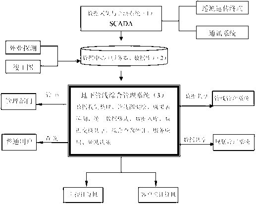
[0032] The GIS-based integrated management system for underground pipelines consists of a data acquisition and monitoring system (Supervisory Control And Data Acquisition, or SCADA system), a data center and an integrated management system for underground pipelines.

[0033] Data acquisition and monitoring system, including:

[0034] 1. Several Remote Terminal Units (RTUs) are used to collect data from fixed monitoring points of underground pipelines, and different types of pipelines measure different types of data, which are sent regularly in wired or wireless ways according to the agreed collection period to the data center. The composition of RTU mainly includes pressure transmitter (or flow meter), data processing and transmission device and battery pack, etc.;

[0035] 2. Communication system, used for information communication between telemetry and remote transmission terminals and data centers;

[0036] Data centers, including:

[0037] The server is used to monitor ...


PUM


Abstract

The invention discloses belongs to the comprehensive management on underground pipelines in cities and industrial parks and aims at comprehensively and scientifically managing relevant situations of underground pipelines and improving the accuracy and the efficiency of working; in order to achieve the purpose, the invention adopts the technical scheme as follows: a GIS (Geographic Information System)-based comprehensive management system for underground pipelines comprises a data acquiring and monitoring system, a data center and a comprehensive management system for the underground pipelines, wherein the data acquiring and monitoring system is used for acquiring data at fixed monitoring points of the underground pipelines; and the data center is used as a server and is used for monitoring a process value and being communicated with process hardware, and the process hardware serves as the data acquiring and monitoring system. The system is mainly applied to comprehensive management on the underground pipelines in the cities and the industrial parks.

Description

technical field [0001] The invention belongs to the category of comprehensive management of underground pipelines in cities and industrial parks, and in particular relates to the comprehensive management of underground pipelines with a large amount of data. Specifically, it involves a comprehensive management system for underground pipelines based on GIS. Background technique [0002] Geographic Information System (GIS) is based on geospatial database, with the support of computer software and hardware, it collects, stores, manages, analyzes, simulates and displays spatially related data, and adopts mathematical model analysis methods , provides dynamic spatial geographic information, and provides a computer technology system for planning, management and decision-making. In recent years, with the rapid development of computers and modern information technology, the importance of basic geographic information system construction in the process of national informatization is i...

Claims


Application Information

Patent Timeline
IPC IPC(8): G06F17/30
Inventor 李楠王熠宁马姗姗于志强赵新华杨立焜
Owner TIANJIN UNIV
Why Eureka
Try Eureka