Supercompact combination satellite navigation receiver

A technology of satellite navigation and ultra-tight combination, applied in the field of satellite navigation, can solve problems such as inability to give positioning results, low sensitivity, and loss of satellite signal lock

Inactive Publication Date: 2012-12-12
ZHEJIANG SCI-TECH UNIV
View PDF5 Cites 19 Cited by
  • Summary
  • Abstract
  • Description
  • Claims
  • Application Information

AI Technical Summary

Problems solved by technology

[0006] The purpose of the present invention is to overcome the low sensitivity of existing GNSS receivers and the disadvantages that satellite signals are out of lock due to interference, and thus cannot provide positioning results, by designing an ultra-tight comb

Method used


Image

  • Supercompact combination satellite navigation receiver
  • Supercompact combination satellite navigation receiver
  • Supercompact combination satellite navigation receiver

Examples


Embodiment Construction

[0029] The technical solution of the present invention will be described in further detail below in conjunction with the accompanying drawings and embodiments, and the following embodiments do not constitute a limitation of the present invention.

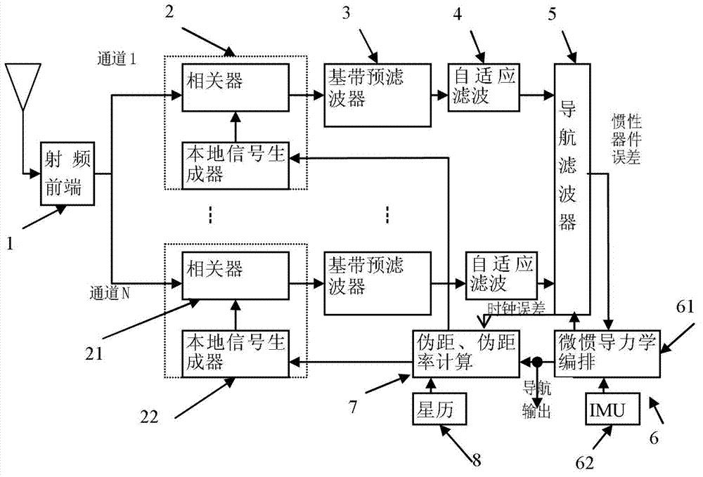
[0030] GNSS / IMU ultra-tight integrated satellite navigation receiver based on vector tracking such as figure 1 As shown, it includes sequentially connected radio frequency front-end 1, signal preprocessor 2, baseband prefilter 3, adaptive filter 4 and navigation filter 5, and micro inertial navigation module 6, pseudorange and pseudorange rate calculation module 7 , ephemeris calculation and star selection calculation module 8.

[0031] The signal preprocessor 2 includes a correlator 21 and a local signal generator 22. The I / Q signal accumulated and output by the correlator 21 is used as the observation input of the baseband prefilter 3. The local signal generator 22 generates a local carrier and pseudo code.

[0032] Wherein the m...


PUM


Abstract

The invention discloses a supercompact combination satellite navigation receiver which comprises a radio frequency front end, a signal preprocessor, a base band prefilter, a navigation filter, a micro inertial navigation module, a pseudo-range and pseudo-range rate calculating module and an ephemeris resolving and start selection calculating module. A self-adaptive filter is arranged between the base band prefilter and the navigation filter. An output of the base band prefilter is used as an input to be switched in the self-adaptive filter and then an output of the self-adaptive filter is used as an observed quantity to be input into the navigation filter to carry out data fusion, and thus, the stability and the tracking accuracy of a tracking loop can be obviously improved, so that the adaption capacity of GNSS (Global Navigation Satellite System) positioning on the environment and the motion state is improved. Furthermore, the vector tracking loop is formed by the signal proprocessor, the base band prefilter, the self-adaptive filter, the navigation filter and the pseudo-range and pseudo-range rate calculating module; and the navigation filter adopts a federated filter, so that the stability and the tracking accuracy of the tracking loop can be improved, and thus, the performances of reliability, positioning accuracy and the like of the GNSS positioning are improved.

Description

technical field [0001] The invention relates to the technical field of satellite navigation, in particular to a satellite navigation receiver with an ultra-tight combination of a Global Navigation Satellite System (GNSS) and a Micro Inertial Navigation System (MEMS-IMU). Background technique [0002] Global Navigation Satellite System (GNSS) is a satellite-based radio navigation system that can provide all-weather, uninterrupted, high-precision, real-time navigation and positioning services for various carriers on land, sea and air. At present, the most widely used global navigation satellite system is the GPS of the United States, which has penetrated into various fields of the national economy and daily life, such as maritime navigation, urban traffic management, commercial logistics management, ship ocean navigation, precise timing, geodesy, precision agriculture, etc. At present, my country has also participated in the construction of the Galileo system, which will be c...

Claims


Application Information

Patent Timeline
IPC IPC(8): G01S19/48
Inventor 高法钦
Owner ZHEJIANG SCI-TECH UNIV
Why Eureka
Try Eureka